For the record, I'm neither an academic nor a scholar, and admittedly, I've never been to many of the places posted here. So if someone should find a mistake, or believe I omitted something, please feel free to email me and I'll correct it.

I can be contacted at dms2_@hotmail.com.

Sunday, December 29, 2019

AMARNA/AKHETATEN

The North Palace
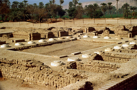
ruins at Amarna (Akhetaten), courtesy, EgyptSites.wordpress.com

Amarna is located on the eastern bank of the Nile in the modern-day province of Minya in central Egypt, some 194 miles south of Cairo, and 36 miles south of the provincial capital city of al-Minya. It is an extensive Egyptian archaeological site dating back to the Eighteenth Dynasty of ancient Egypt. Today, several, largely indigenous Coptic villages are located adjacent to, or around, the site: Deir Mawas, el-Tell, el-Hagg Qandil, Deir el-Bersha, Mallawi.
“Amarna” is actually Arabic, named after the Arab tribe that invaded and occupied the place. It was originally called “Akhetaten” by the ancient Egyptians meaning “horizon of the Aten” because it was built as the new capital city of the Pharaoh Akhenaten, dedicated to his new religion of worship to the Aten. Construction of Akhetaten started in or around Year 5 of his reign (1346 BC) and was probably completed five years later, during which time, it officially became the capital city. Most of the buildings were constructed out of mud-brick, and white washed. The most important buildings were faced with local stone.
It was laid out roughly north to south along a "Royal Road" – the further from the Road, the poorer the neighborhoods. The Royal residences were generally to the north, in what is known as the North City, with a central administration and religious area. The South City was made up of residential suburbs containing the estates of many of the city's powerful nobles, including Nakhtpaaten (Chief Minister), Ranefer, Panehesy (High Priest of the Aten) and Ramose (Master of Horses). This area also held the studio of the sculptor Thutmose, where the famous bust of Nefertiti, chief wife of Akhenaten, was found in 1912.
South of this area was Kom el-Nana, an enclosure, usually referred to as a sun-shade, and was probably built as a sun-temple. It was Akhenaten’s wish to have several temples of the Aten to be erected here, as well as for the royal tombs to be created in the area’s eastern hills for himself, Nefertiti and his eldest daughter Meritaten. The Maru-Aten, which was a palace or sun-temple was originally thought to have been constructed for one of Akhenaten's wives Kiya, but on her death her name and images were altered to those of Meritaten.
The city greatly declined during the reign of his son Tutankhamun, who began to reign two years after his father’s death. He decided to leave the city and return to his birthplace in Thebes, but Akhetaten seems to have remained active and a shrine to Horemheb indicates that it was at least partially occupied at the beginning of the reign of that Pharaoh, if only as a source for building material elsewhere.
After the death of Horemheb, the city was finally abandoned and remained so until Egypt came under Roman rule. Akhetaten revived and new settlements were established nearby along the edge of the Nile, namely, the villages of Deir el Bersha and Mallawi, both established directly across the river. When Christianity was introduced to Egypt, the local inhabitants adopted the new religion and their descendants have remained on that same spot since then.
During the early period of Christianity, several local churches and monasteries were established. In the 4th century, Saint Pishoy established his monastery, eventually named after him, in Deir is Bersha. This was part of a chain of monasteries he established throughout Egypt but when he died in 417, he was buried at the monastery in Bersha alongside his friend and fellow “desert father” Saint Paul of Tammah who died 2 years previously. However, some say it was his wish to be buried at one of the other monasteries he founded, specifically one located at Wadi el Natrun, in the north near the Nile Delta. In 841, his wish was carried out by Pope Joseph I who transferred his remains accordingly. Other churches that were prominent in Bersha include the Deir Abu Fam Tombs Coptic Orthodox Church, the Church in the Tomb of Urarna, and the Virgin Mary and Anba Abraam Coptic Orthodox Church (destroyed by Arabs in 2013).
For centuries thereafter, European explorers and archaeologists have occasionally covered the area but in 1887, a local woman digging for sebakh, decomposed mud brick, uncovered a cache of over 300 cuneiform tablets (now commonly known as the Amarna Letters). These tablets recorded select diplomatic correspondence of the Pharaoh and were predominantly written in Akkadian, the lingua franca commonly used during the Late Bronze Age of the Ancient Near East for such communication. This discovery led to the recognition of the importance of the site, and lead to a further increase in exploration. In 1891, a “dig house” was built by German archaeologist Ludwig Burchhardt as a storage base for artefacts recently discovered.
Since then, archaeologists have been making remarkable finds. They include: stelae dedicated to Isis and Shed,cemetery of private individuals, the Royal Wadi, the North Riverside Palace, the Great Temple of the Aten, the Small Aten Temple, the ceremonial residence of the King and Royal Family, the Bureau of Correspondence of Pharaoh, the Boundary Stelae (each a rectangle of carved rock on the cliffs on both sides of the Nile) describing the founding of the city, the Royal necropolis, Workmen's village, Tomb of Akhenaten, Northern tombs, Southern tombs, Stelae U, Desert altars, Northern Palace, and Stelae H.


Wednesday, December 25, 2019

DURA EUROPOS

ruins of the Church House in Dura Europos, courtesy, Wikipedia
Dura-Europos is an ancient archaeological site of the Aramean Syriacs, the indigenous people of the area, located in, what is today, the southeastern part of Arab-occupied Syria near the west bank of the Euphrates River. Famous as the site of a 3rd century synagogue, in a remarkable state of preservation when discovered by archaeologists in the 1930s, the area is also home to other sites which pre-date the synagogue. Today, Dura Europos is located adjacent to the illegal Arab settlement of al-Salihiya. But religiously, it is under the jurisdiction of the Syriac Orthodox Church. Until the 11th century, the nearest church bishopric was at Circesium, 40 miles to the north.

Originally a fortress, Dura Europos was founded in 303 BC on Aramean Syrian land by settlers from, what is today, Greece and Macedonia in southeastern Europe, under Emperor Seleucus I Nicator, a former general in the army of Alexander the Great. The Greeks called the place “Dura”, located on the east-west and Euphrates trade routes. Indeed, Dura controlled the river crossing on the route between the newly founded cities of 
Antioch and Seleucia on the Tigris. Because of the city’s importance in location, it became a regional capital and a great caravan city and had close ties with nearby Palmyra. (The Palmyrene Gate was the principal entrance to the city.) Soon, the population became cosmopolitan and allowed for a co-mingling of cultural traditions. Aside from the original Greek and Syriac inhabitants, the general population was also made up of Romans, Israelites, Palmyrenes, Persians, and south Semitic peoples but the local social system continued to have the descendants of the original Macedonian/Greek settlers as the aristocracy. Even though the Greeks were eventually outnumbered by people of Semitic stock by the first century BC, and the city became eastern in character, this social system remained intact until the city’s abandonment in the middle of the 3rd century. The mix of populations was also reflected in the area's sacred architecture. For instance, by the 1st century, citizens from Palmyra, an important trade center, built temples to their gods Aphlat and Azzanathkona, and later (168-9) built the Mithraeum to honor the sun god Mithras. At the same time, citizens from nearby Anah built the Temple of Zeus Kyrios. In the first half of the 3rd century, the indigenous Syriacs built the Christian Church House, one of the oldest churches in the world outside of Israel. Inside of the church is the earliest known baptismal font as well as what is thought to be the earliest depiction of Jesus dating back to 235.
In 113 BC, the Parthians from Persia conquered the city, and held it, with one brief Roman intermission (114), until 165 when the Romans decisively conquered the city and built a military camp adjacent to it. The Romans added “Europos” to the city name because of its long-time European Macedonian/Greek aristocracy. Through an agreement with the new overlords, Dura Europos retained its status as regional headquarters for the section of the Euphrates between the Khabur and modern Abu Kemal and the local inhabitants would retain considerable freedom. In exchange the city’s military role was abandoned.  
In 256, Dura Europos was conquered by the Persian Sassanid Empire and the town was laid siege for a year. Most of the population was deported. The rest were marched off to Ctesiphon and there sold as slaves. Afterwards, it was bereft of any population at all and over time, the site was covered over by sand and mud and disappeared from sight.
Since then, the existence of Dura-Europos had long been known through literary sources. In 1885, it was rediscovered by the American "Wolfe Expedition" when the Palmyrene Gate was photographed by John Henry Haynes. British troops under Capt. Murphy in the aftermath of World War I and the Arab Revolt also explored the ruins. On March 30, 1920, a soldier digging a trench uncovered brilliantly fresh wall-paintings in the Temple of Bel. Afterwards, major excavations were carried out by French and American teams. Archaeological activity continued until renewed hostilities in the area caused the site to be closed. In 1933, excavations resumed. Sites uncovered included: the Temple of the Oriental Gods; the Temple of Adonis; the Temple of the Gadde; the Temple of Zeus Theos; and the Dura-Europos Route map, the fragment of a specialty map discovered in 1923.
Since 1986, joint excavations were established between French and Syrian Arab archaeologists under the direction of Pierre Leriche but the site was looted and mostly destroyed between 2011 and 2014 by the Islamic State during the Syrian Arab Civil War.

Tuesday, December 17, 2019

DJERBA

desert scene in Djerba, courtesy, galileo3000.si
The island of Djerba is, at 198 square miles, the largest island of North Africa, located in the Gulf of Gabès, and is politically, a part of Arab-occupied Tunisia. It is famous as the filming location of Star Wars which took place in and around the port of Ajim in the southwest corner of the island. Tourists can visit buildings featured in the original movie, including Obi-Wan Kenobi's house and the Mos Eisley cantina. The island is also famous for its ancient Jewish community and its indigenous inhabitants, the Amazigh (Berbers). Out of a total population of over 163,000, 15,000 belong to this indigenous community.
In ancient times, the Djerba Amazigh would often be influenced by the neighboring peoples from across the Mediterranean as well as the occupying empires that came and went throughout this period. Legend has it that Djerba was the island of the lotus-eaters where Odysseus was stranded on his voyage through the Mediterranean. The island, which was called Meninx until the third century AD, included three principal towns: one, known today as Būrgū, is found near Midoun in the center of the island; another, on the southeastern coast, which is as yet, unidentified, was a major producer of priceless murex dye, and is cited by Pliny the Elder as second only to Tyre in this regard; and the third was the ancient Haribus. The island was densely inhabited in the Roman and Byzantine periods, and probably imported much of the grain consumed by its inhabitants.
During the Middle Ages, Djerba was invaded and occupied by Arabs who followed the Ibadi form of Islam. They had a tremendous impact on the indigenous inhabitants who eventually became followers of this form of Islam. But since then, a slow process of Arabization set in forcing them to fight for their own cultural identity and rights. But in spite of this, there were also periods when the island came under indigenous rule, such as during the period of the Zirid dynasty of Sanhaja Berbers and that of the Hafsids who were Sunni Muslim Berbers. After the Hafsids expelled a garrison of Spanish soldiers from the island at the end of the 14th century, they built the Borj el Kebir Castle to the north of the town of Houmt Souk over the ruins of the ancient Roman city of Griba. In 1450, the castle was extended. In 1574, the Hafsids were overthrown by the Ottoman Turks and they, in turn, were overthrown by the French in the 19th century.  
After the French left Tunisia and Djerba in 1956, the process of Arabization resumed and so has the fight for Amazigh rights. The Amazigh have only been partially successful though. In general, many have lost aspects of their traditional identity. The Djerba Berber language called chilha, a language mainly derived from the ancient Zenata Berbers, is only spoken by some in the local villages, including Tlat, Ajim, Sedriane, Azdyuch, and Mahboubine. But only those in Sedouikech have learned to write it and the viability of chilha in the villages of Tlat and Ajim is tenuous with each passing generation. Only the elderly in these and other villages can speak it. They have ceased teaching their children due to its “difficulty”. Nowadays, the Djerba Amazigh speak Arabic and French and a minority learn other languages including English. Their clothing has also changed due to integration with the Arabs with many now wearing European-style clothing. In addition, radio, television, and the internet have taken hold of the younger generation.

On the other hand, the Amazigh of Guellala, Ouirsighen, and a minority of those from Sedouikech, have held on to their Amazigh identity and are proud of it. The Amazigh in Sedouikech work in commerce and especially in agriculture, producing quantities of olive oil. The inhabitants of Ouirsighen are considered well off with some living abroad, often in Europe, and sending back money to their families. Those of Guellala are well-known for their pottery, a profession that has been passed down from generation to generation. The town used to be home to hundreds of potters, but today only a handful can be seen busy at work in their workshops. With the passing of time, evolving material needs, and difficulty of the profession, the youth have begun to search for work in industrial and commercial locations. The town’s indigenous culture seemed on the verge of being forgotten. In response, the Guellala Museum was established on a hill overlooking the town as a depository of “Berberana”. The permanent exhibition includes a large collection of traditional tools and garments and everyday objects used in the past by the islanders. Also on display are life-size figures enacting scenes of everyday life like fishing, weaving and olive oil making, and also wedding ceremonies.

However, the interactions between men and women more closely follow the Arabian Bedouin tradition that came with their invasion and occupation of the area. As a result, men and women do not mix socially, and they continue to wear their traditional clothing.

There is a strong and close relationship between the island’s Amazigh and Jews. In the season of Jewish pilgrimage in Djerba the Amazigh ensure their safety. The Jews, for their part, consider the Amazigh trustworthy in commerce and business dealings.

A major geographical feature of the island is the Djerba Bin El Ouedian wetland and habitat for migratory birds. On November 7, 2007 the wetland was included on the list of Ramsar sites under the Ramsar Convention, due to its importance as a bird refuge.

Sunday, December 8, 2019

DEAD SEA

Photo of the view from the research site at Ein Bokek (southern Dead Sea), to the Jordanian side.
Dead Sea view from Ein Bokek, courtesy, NSF.gov
The Dead Sea is the lowest place on earth at over 1,400 feet below sea level and, even though it is fed by the Jordan River from the north, its present size has shrunk to 234 square miles – at approximately 46 miles long – from 410 square miles in 1930, and shrinking fast. Since this site has such a high salinity rate, it is called “Yam haMelakh” (Sea of Salt) in Hebrew. No plants or animals can flourish in it, and because of this, the Europeans call this place the “Dead Sea” by Europeans. On the other hand, it is rich in natural resources especially potash.

It lies squarely in between Israel on the west and Arab-occupied Jordan on the east. Historically though, it was bounded on the west and northeast by the Land of Israel, specifically, the tribe of Judah on the west and the tribe of Reuven on the northeast. Along the southeastern quarter lie the Kingdom of Moab. The Biblical Arnon River, today referred to as Wadi Mujib, which flows into the Sea, has historically separated Reuven from Moab. On the southern extremity of the Sea, lie the Kingdom of Edom. Between Moab and Edom is the Zered brook, today, Wadi al Hasa, which also flows into the Sea, and which has historically separated those two kingdoms. Along the southwestern side of the lake is the 700 foot tall "Mount Sodom" of Sodom and Gamorrah fame. At Mount Sodom is a stony outcrop called by the local Bedouin “Lot’s Wife” due to its shape that, some say, resembles Lot’s wife who looked back after Sodom’s destruction and turned into a pillar of salt, according to the Biblical account. Many animal species live in the mountains surrounding the Dead Sea - ibexhareshyraxesjackalsfoxes, and even leopards. Hundreds of bird species inhabit the zone as well and nature reserves were established by both Jordan and Israel.
In the Talmud the Dead Sea was called Yammah shel Sedom, "the Sea of Sodom" and was considered within the juridical boundary of Ereẓ Israel (tj, Shev. 6:1, 36c). According to R. Dimmi, "no one ever drowns in the Sea of Sodom" (Shab. 108b). Throwing an object into the sea was suggested as a means of disposing of a religiously or morally undesirable advantage which a person had received unintentionally (Av. Zar. 3:9; Av. Zar. 49b; Tosef., Dem. 6:13, etc.). The Talmud (Shab. 108b) mentions the density of the water, and says that a bath in the Dead Sea is considered good for certain ills, especially diseases of the eye, although the salt extracted from the sea was considered noxious to the eyes (Ḥul. 105b). Because of the poisonous air about the sea no ship sailed on it.
In Joshua 15:62, Ein Gedi, located midway on the western side of the Sea, was enumerated among the wilderness cities of the Tribe of Judah in the desert of Betharaba, and in Ezekiel 47:10, it was prophesied that one day, its coastal location will make it into a fishing village, after the water of the Dead Sea has been made sweet: Fishing nets will be spread from En-gedi to En-eglaim. Fleeing from King SaulDavid hid in Ein Gedi (1 Samuel 23:29 and 24:1-2) and Saul sought him "even upon the most craggy rocks, which are accessible only to wild goats" (1 Samuel 24:2). Psalm 63, subtitled a Psalm of David when he was in the wilderness of Judah, has been associated with David's sojourn in the desert of En-gedi. The Song of Songs (Song of Solomon 1:14) speaks of the "vineyards of En Gedi". The town was mentioned many times in the Mishna, as a producer of persimmon for the temple's fragrance and for export, using a secret recipe. "Sodomite salt" was an essential mineral for the temple's holy incense, but was said to be dangerous for home use and could cause blindness. 2 Chronicles 20:2 noted that Ein Gedi was surrounded with an abundance of palm groves. It was here that the Moabites and Ammonites gathered in order to fight King Josaphat of Judah. Ein Gedi was destroyed or abandoned after the Babylonian destruction of Jerusalem in 587/86 BCE. In the 2nd century BCE, it received a fortress and became a royal Hasmonean estate.
The Jewish historian Josephus writes that Masada was first fortified by Hasmonean ruler Alexander Jannaeus in the first century BCE. It survived the siege of the last Hasmonean king Antigonus II Mattathias, who ruled with Parthian support. Josephus further writes that Herod the Great captured it in the power struggle that followed the death of his father Antipater and between 37 and 31 BCE, built a large fortress on the plateau as a refuge for himself in the event of a revolt. He also erected there two palaces.
During the Roman occupation, John the Baptist was imprisoned by Herod Antipas at the fortress of Machaerus, on the eastern bank, and died there. At the same time, groups of Essenes settled on western bank including the fortress of Qumran which was constructed during the reign of John Hyrcanus (134–104 BCE) or somewhat later. When the Jewish Revolt against Rome broke out in 66, Vespasian's ships would often pursue Jewish refugees fleeing by way of the Dead Sea. At the same time, the extremist Jewish rebel group, the Sicarii, antagonists to the Zealots, overcame the Roman garrison of Masada with the aid of a ruse. After the destruction of the Second Temple in 70, additional members of the Sicarii fled Jerusalem and settled in Masada after slaughtering the Roman garrison. Josephus writes that the Sicarii would raid nearby Jewish villages including Ein Gedi, where they massacred 700 women and children. The siege of Masada by Roman troops from 73 to 74, at the end of the First Jewish–Roman War, ended in the mass suicide of 960 Sicarii rebels who were hiding there. Qumran was also destroyed. Documents from the time of the Bar Kokhba War (132–135) found in the surrounding caves indicate that En-Gedi was the main supply port for the Jewish army during the final phase of this war. Later, Ein Gedi became an important source of balsam for the Greco-Roman world until its destruction by Byzantine emperor Justinian as part of his persecution of the Jews in his realm.
From that time until the modern era, the Dead Sea area was totally desolate save for a few Bedouin. After the find of the "Moabite Stone" in 1868 on a plateau east of the Dead Sea, Moses Wilhelm Shapira, a Polish-Jewish antiquities dealer, and his partner Salim al-Khouri, forged and sold a whole range of presumed "Moabite" antiquities, and in 1883 Shapira presented what is now known as the "Shapira Strips", a supposedly ancient scroll written on leather strips which he claimed had been found near the Dead Sea. The strips were declared to be forgeries and Shapira took his own life in disgrace.
In 1929, Moshe Novomeysky, a Jewish engineer from Siberia who first visited the Dead Sea area in 1911, won the British government tender for potash mining on its northern shore after working for the charter for over ten years. The site’s marshland was drained and housing was built to accommodate employees of the newly-founded Palestine Potash Company (today, the Dead Sea Works) and its first plant was established on the site. Kibbutz Kalia was born. The plant produced potash, or potassium chloride, by solar evaporation of the brine. It employed both Arabs (mainly from Jericho) and Jews. The next year, on the initiative of Novomeysky and Palestine Potash, the first potash and bromine works were built at Rabbat Ashlag near Kalia in 1930 and it grew into the largest industrial site in the Middle East. In 1934, the company built a second plant on the southwestern shore, in the Mount Sedom area. A supplementary plant in the same location was opened in 1937. Among the pioneers working at both places was a group composed of members of Ha-Kibbutz ha-Me'uḥad which called itself "Pelugat Yam ha-Melaḥ."
During the late 30s, Kalia opened a resort hotel. It was spared the violence of the Arab riots due to good relations with the Arabs and during World War II, Palestine Potash Company supplied half of Britain's potash. In 1939, kibbutz Bet ha-Aravah was established northeast of Rabbat Ashlag. Beginning in 1947, hundreds of religious documents dated between 150 BCE and 70 CE were found by a local Bedouin in caves near the ancient settlement of Qumran, about one mile inland from the northwestern shore of the Dead Sea. They became known as the Dead Sea Scrolls.
During the War of Independence, the Dead Sea area suffered major damage. The potash plants on both ends of the Sea were destroyed by the Jordanians. Despite negotiations between the Kalia leadership and Jordan's Arab Legion to preserve the kibbutz under Jordanian occupation, the imprisonment of Jews in the Jordanian-occupied Naharayim complex and the Kfar Etzion massacre, not to mention their total isolation, led David Ben-Gurion to call for the residents' evacuation and their consolidation in the southern Dead Sea. Residents of Kalia and nearby Beit HaArava ultimately fled by boat on May 20 and the two kibbutzim were destroyed by the Jordanians. The area remained unpopulated save a Jordanian military camp. In "Operation Lot" (October 1948) overland contact with Sedom was reestablished, and in March 1949 units of the Israeli Army moved along the Dead Sea shore north to the site of En-Gedi which had been allocated to the Jewish state in the 1947 UN partition plan.
After the War, all points north of the Ein Gedi, which included places like Qumran, was off-limits to Israelis, and Jews in general, with rare exceptions. In 1966, Jewish journalist and archaeologist Solomon Steckoll received rights from the Jordanian government to excavate in the Qumran area.
After the War, the chief of staff of the Israel Defense Forces (IDF), Moshe Dayan, initiated the practice of holding the swearing-in ceremony of Israeli Armoured Corps soldiers who had completed their tironut (IDF basic training) on top of Masada. The ceremony ended with the declaration: "Masada shall not fall again."
By 1952, the Palestine Potash Company was revived as the Dead Sea Works, a state-owned enterprise. In 1953, the ancient town of Ein Gedi was revived as a kibbutz. And in 1955, the new Sedom potash plant of the Dead Sea Works began operating after the Beersheba-Sedom highway was completed. This highway was followed the next year with the building of the Sedom-Ein Gedi motor road. The Arad-Sedom and Sedom-Eilat highways were constructed in 1964 and 1967 respectively. These not only aided production and marketing of the Dead Sea Works but also created conditions for the development of the tourism and recreation in the region.
Archaeological activity has always been intense in this area, especially in and around Masada, Ein Gedi, and Qumran, and especially since independence. After visiting Masada several times in the 1930s and 1940s, Shmarya Guttman conducted an initial probe excavation in 1959. Ten years later, Yigael Yadin discovered a few skeletal remains at the site. After concluding that they were the Jewish defenders against Rome, they were reburied in a state ceremony by Israel’s rabbinate. Other famed Israeli archaeologists who conducted excavations in the area include: Yohanan Aharoni, Amir Drori, Yitzhak MagenMagen Broshi, Hanan EshelYuval Peleg, Oren Gutfield, and Yizhar Hirschfeld. 2,000-year-old Judean date palm seed discovered during excavations in the early 1960s was successfully germinated into a date plant, popularly known as "Methuselah" after the longest-living figure in the Hebrew Bible. At the time, it was the oldest known germination, remaining so until a new record was set in 2012. As of September 2016, it remains the oldest germination from a seed.
Since the early 60s, major hotels were built along the Dead Sea. Neve Zohar, in ancient times, a major transport junction, was re-established in 1964 as a work camp for Dead Sea factory workers. It was named after the Zohar Stream, a wadi that flows into the Dead Sea. The liberation of the Judean Desert from Arab occupation, and the entire west coast of the Dead Sea by Israel in the Six-Day War made the region again easily accessible from Jerusalem. Kalia was re-established, as a paramilitary Nahal settlement in 1968, the first in the area. It was turned over to civilian use in 1972. In the late 1960s a restaurant, hotel, picnic camps, and a museum of the Dead Sea Works were opened at Shefekh Zohar, as well as the Ein Bokek resort complex making use of medicinal springs and thermal mud, youth hostels, etc. In 1970, the town of Mitzpe Shalem was founded in 1970 as a Nahal settlement and became a kibbutz in 1976. It was named after Natan Shalem who investigated the area of the Judean Desert where the kibbutz is located. In 1971, the Ein Gedi nature reserve was founded. The settlement Ein Tamar was established in August 1982 by 24 families on the site of the Biblical town of the same name near the Hatzeva Fortress near Ir Ovot. Ein Tamar and the neighboring village of Neot HaKikar are among the country's most remote places, forty minutes away from the nearest city, Dimona. Ovnat was founded in mid-2004 where a Nahal settlement previously existed. The religious high school "Yiftach" is located there, and some of the residents work there. The Ein Gedi race, also known as the Shalom Marathon – Dead Sea Half Marathon is a popular road running event over several distances that has been held by the Tamar Regional Council since 1983. In 1988, Ahava Skin Care products was established in Mitzpe Shalem. In 1995, the Dead Sea Works was privatized and it is now owned by Israel Chemicals. In 2007, the Masada Museum in Memory of Yigael Yadin opened at the site, in which archeological findings are displayed in a theatrical setting. The world's lowest installed ATM is at Ein Bokek; it was installed independently by a grocery store at 1,381 feet below sea level.
The Dead Sea temporarily comes to life in the wake of rainy winters. In 1980, after one such rainy winter, the normally dark blue Dead Sea turned red. Researchers from Hebrew University of Jerusalem found the Dead Sea to be teeming with a type of algae called DunaliellaDunaliella in turn nourished carotenoid-containing (red-pigmentedhalobacteria, whose presence caused the color change. Since 1980, the Dead Sea basin has been dry and the algae and the bacteria have not returned in measurable numbers. In 2011 a group of scientists from Israel and Germany discovered fissures in the floor of the Dead Sea by scuba diving and observing the surface. These fissures allow fresh and brackish water to enter the Dead Sea. They sampled biofilms surrounding the fissures and discovered numerous species of bacteria and archaea.
In December 2013, Israel, Jordan and the Palestinian Authority signed an agreement for laying a water pipeline to link the Red Sea with the Dead Sea. The pipeline will be 110 miles long and is estimated to take up to five years to complete. 
Neve Midbar Beach at the northern end of the Dead Sea is a small private resort with a section of the shore set aside as a nude beach. Metsoke Dragot Beach by the Dead Sea, is an oasis where a couple of sweet water springs pour into the Dead Sea. The Dead Sea area has become a location for health research and potential treatment for several reasons. The mineral content of the water, the low content of pollens and other allergens in the atmosphere, the reduced ultraviolet component of solar radiation, and the higher atmospheric pressure at this great depth each may have specific health effects. For example, persons experiencing reduced respiratory function from diseases such as cystic fibrosis seem to benefit from the increased atmospheric pressure. Rhinosinusitis patients receiving Dead Sea saline nasal irrigation exhibited improved symptom relief compared to standard hypertonic saline spray in one study. Dead Sea mud pack therapy has been suggested to temporarily relieve pain in patients with osteoarthritis of the knees. The Zohar Hot Springs are located three kilometers south of Ein Bokek. Rich in sulphur, the water is believed to be particularly beneficial in the treatment of muscular ailments, diseases of the joints and allergies.