For the record, I'm neither an academic nor a scholar, and admittedly, I've never been to many of the places posted here. So if someone should find a mistake, or believe I omitted something, please feel free to email me and I'll correct it.

I can be contacted at dms2_@hotmail.com.

Showing posts sorted by date for query nazareth. Sort by relevance Show all posts

Saturday, September 4, 2021

TRIBE OF ZVULUN

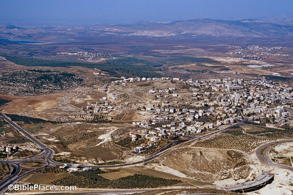
Gath Hepher aerial from south, 122-02tb_psp
view of Gath Hepher, courtesy, BiblePlaces.com
According to the Torah, the tribe of Zvulun consisted of the descendants of Zvulun, sixth son of Jacob and Leah, from whom the tribe took its name. In the census of the tribes in the Desert of Sinai during the second year of the Exodus, Zvulun numbered 57,400 fighting men (Numbers 1:31). Under the command of Eliab, son of Helon, they encamped with Judah and Issachar east of the Tabernacle, and with them, made up the vanguard of the line of march (Numbers 2:3–9). Among the spies sent by Moses to view the Land of CanaanGaddiel son of Sodi represented Zvulun (Numbers 13:10). At Shittim, in the land of Moab, after 24,000 men were slain for their crime, a second census was taken. This time, Zvulun numbered 60,500 fighting men (Numbers 26:27). 

When the Israelites crossed over into the Land of Canaan, Elizaphan, son of Parnach, led Zvulun and represented the tribe when the land was divided. The tribal allotment to Zvulun was described in the Book of Joshua 19:10-15: “And the third lot came up for the children of Zvulun according to their families; and the border of their inheritance was unto Sarid; And their border went up toward the sea, and Maralah, and reached to Dabbeshet, and reached to the [Kishon?] river that is before Yokneam; And turned from Sarid eastward toward the sunrising unto the border of Chisloth-tabor, and then goeth out to Daverat, and goeth up to Japhia, And from thence passeth on along on the east to Gath Hepher, to Ittah Kazin, and goeth out to Remmon Methoar to Neah; And the border compasseth it on the north side to Hanaton: and the outgoings thereof are in the valley of Jiphthah El; And Kattath, and Nahalal, and Shimron, and Idalah, and Bethlehem: twelve cities with their villages.” Of the nineteen locations listed, only Bethlehem of Galilee (seven miles northwest of Nazareth) can be identified with certainty, although the archaeological site Tel Hanaton is associated with the city Hanaton listed as on the boundary with Asher.

In the ancient Song of Deborah, Zvulun is described as sending to battle those that handle the sopher shevet. Traditionally this has been interpreted as referring to the "rod of the scribe", an object that in Assyrian monuments was a wooden or metal stylus used to inscribe on clay tablets or papyrus; thus, those who wielded it would have been the associates of lawgivers. Therefore, in Jewish tradition, the tribe of Zvulun was considered to have a symbiotic relationship with the tribe of Issachar, its neighbor and a tribe that traditionally was seen as having many scholars who disseminated the teaching of Torah and learning. They tended to be financially supported by Zvulun who would, in turn, receive a share of the spiritual reward from such learning.

During the time of the Judge Gideon, the tribe answered the call to join in the battle against Midian (Judges 6:35). Among Gideon’s successors was the Zvulunite Elon, who sat as judge of the nation for ten years (Judges 12:11). Of those who followed David to Hebron to make him king were 50,000 fully armed men of Zvulun with no double heart (I Chronicles 12:33), who brought with them, as a sign of their hearty allegiance, bounteous supplies of meat and drink to celebrate the accession of their new ruler (I Chronicles 12:41). When Hezekiah made reparation for the abominations of his father Ahaz, he invited all Israel, whether in the southern Kingdom of Judah or the northern Kingdom of Israel, to keep the Passover in the House of the Lord. Mockery and ridicule met his emissaries. Yet some were true to the religion of their fathers, and, even from far away Zvulun, they made the pilgrimage to Jerusalem, and in the process, destroyed the idols there (II Chronicles 30:10–23). As part of the Kingdom of Israel, the territory of Zvulun was conquered by the Assyriansand they, along with the 10 other tribes that made up the Kingdom of Israel,  were exiled, and soon became known as the Lost Tribes of Israel – until in very recent years.

Since then, Jews/Israelites, mostly of the tribe of Judah, have resettled the area. According to the Christian New Testament, Jesus was raised in Nazareth which is in Zvulun territory. The Gospels relate much about his Galilean ministry which mainly took place in this territory. After the Roman destruction of Jerusalem in 70, Jews still lived in the area, but on and off. The Tomb of Jonah in Gath Hepher became a place of pilgrimage. It was even mentioned in the 12th century by the Jewish medieval geographer Benjamin of Tudela. The ancient Zvulunite town of Shimron was mentioned by the geographer Ishtori Haparchi in his "Kaftor va-Feraḥ" in 1322. In 1850, the ancient site of Nahalal was identified by the geographer and scientist Rabbi Joseph Schwarz. In 1921, most of the Jezreel Valley, which mostly lies within Zvulun territory, was acquired by the Palestine Land Development Company, a Jewish company under Yehoshua Hankin, as part of the Sursock Purchase. (The Sursock family was a Greek Christian family of Beirut.) That year, Nahalal was reestablished as the first moshav ovdim (workers' cooperative agricultural settlement). (see Jezreel Valley, Nahalal) In 1926, Sarid was established as a kibbutz by Jews from CzechoslovakiaPoland and the Soviet Union. On the other hand, by 1931, only 1 Jew lived in Bethlehem of Galilee, then, a settlement of German Templars. The first families arrived in Yokneam in 1935. In 1936, Kibbutz Hazorea was established by German Jews. That same year, the site of Shimron became an agricultural training station for the Moshavim Movement, becoming Kibbutz Timorim in 1948. Kibbutz Dovrat was established on October 30, 1946 on the ancient site of Daverat by members of the Zra'im group, mostly Jews from Austria and Germany who arrived before the start of World War II. Shortly after the War of Independence, Jewish farmers began to move into the region, joining existing communities and establishing new ones such as Bethlehem of Galilee.

Israeli Knesset member Ayoob Kara, a member of the Druze community, speculated that the Druze are descended from one of the Lost Tribes of Israel, probably Zvulun. Kara stated that the Druze share many of the same beliefs as Jews, and that he has genetic evidence to prove that the Druze were descended from Jews.

Friday, January 1, 2021

NAHALAL

Aerial view of Nahalal
aerial view of Nahalal, courtesy Wikipedia
Nahalal is a moshav in northern Israel, just south of the Nahal Shimron and roughly 9 miles west of Nazareth. It is governed by the Jezreel Valley Regional Council. In 2019 it had a population of 930.

Nahalal is best known for its general layout, as designed by Richard Kauffmann: slightly oval, similar to a spoke wheel with its public buildings at the "hub" and individual plots of agricultural land radiating from it like spokes with symmetrically placed roads creating eight equal sectors, an inner ring of residential buildings, and an outer ring road.

During Biblical times, Nahalal was allotted to the tribe of Zvulun but designated a Levitical city belonging to the Merari clan. Among the archaeological artifacts found in the area, was an ancient Jewish inscription of the word "Sabbath" written on a rock. In the Talmud (tj, Meg. 1:1, 70a), Nahalal is identified with Mahalol, which corresponds to the present-day Arab settlement of Ma’alul. In 1850, explorer Rabbi Yehoseph Schwarz visited the area and definitely identified this settlement with the Biblical Nahalal.

In 1921, the land was sold by the Sursock family of Beirut, to the Zionist, Palestine Land Development Company, soon to transfer ownership to the Jewish National Fund. Nahalal’s founders immigrated to Palestine from Eastern Europe as part of the Second and Third Aliyah between 1904 and 1914, at the end of Ottoman rule. They saw that the allotted land contained small rivulets which transformed the plain into marshes that attracted malaria-spreading mosquitoes. Heeding the warnings of experts, such as Dr. Hillel Yaffe, the Jewish pioneers temporarily settled on a nearby hill, near Ma'lul. The swamps were drained and the pioneers, eventually, came down from the hill and divided the former swampland into 80 equal parcels, 75 to the members and 5 to the Nahalal agricultural school. They had a somewhat different ideology from the socialist kibbutz model where everything was collectively owned. Thus, Nahalal became the first moshav ovdim (workers' cooperative agricultural settlement) in Mandatory Palestine where individual farms were privately owned

In 1929, a Girls' Agricultural Training Farm was established at Nahalal by Hana Meisel of the Women's International Zionist Organization, and in the 1940s it became a co-educational farming school of the Youth Aliyah movement.

More water became available in the 1930s from the *Mekorot regional network and deep wells were drilled in the vicinity. Farming then became more intensive, fruit orchards were added, and existing branches expanded. The main farming branches, aside from the fruit orchards, were dairy cattle, poultry, flowers, and field crops.

Other major sites in Nahalal include: the Cheese with Ephrat culinary school; Nahalal High School; the Galilee International Management Institute; the public pool; the Bet Haam cultural center; Danieli Olive Oil grocery store; Lavido Cosmetics; and Nahalal Junction.

Wednesday, March 4, 2020

GALILEE

panorama view of the Galilee, courtesy, Wikipedia
The Galilee is a region in what is today, northern Israel and southern Lebanon. In Biblical times, it covered the Israelite tribal territories of Asher, Naphtali, Zvulun, Yissasschar, and the northern branch of Dan. After the destruction of Jerusalem, it was also home to two of the four holy cities of Judaism – Safed and Tiberias – as well as the ports of Haifa and Acre. It extends north to south, from the Litani River in southern Lebanon in the north to the Mount Carmel-Mount Gilboa ridge in the south. From east to west, it stretches from the Acre coastal plain north of Haifa in the west to the northern Jordan Valley in the east. It also consists of a sliver of land between Dan and the Golan Heights including the foothills of Mount Hermon. In addition, the Galilee is often divided into several sub-regions: Lower Galilee; Upper Galilee; the Jezreel Valley; the "Galilee Panhandle"; the northern Jordan Valley; the Hula Valley; the Korazim Plateau; the Sea of Galilee and its valley; the Beit She'an Valley; Mount Gilboa; and Western Galilee. Demographically, the region is almost half Arab, almost half Jewish, and the rest, Druze and others. The largest cities in the region are Acre, Bet She’an, Nahariya, Nazareth, Cana, Metulla, Qiryat Shmona, Safed, KarmielShaghurShefa-'AmrAfula, and Tiberias. The port city of Haifa serves as a commercial center for the whole region.
The area’s Israelite name is from the Hebrew word “Galil”, “district”. The Hebrew form used in Isaiah 8:23 (or 9:1 in different Biblical versions) is “Galil haGoyim”, 'district of the nations', i.e. the part of Galilee inhabited by Gentiles at the time that the book was written. Chapter 9 of 1 Kings states that Solomon rewarded his Phoenician ally, King Hiram I of Sidon, with twenty cities in the land of Galilee, which would then have been either settled by foreigners during and after the reign of Hiram, or by those who had been forcibly deported there by later conquerors such as the Assyrians. Hiram, to reciprocate previous gifts given to David, accepted the upland plain among the mountains of Naphtali and renamed it for a time, "the land of Cabul". During the expansion under the Hasmonean dynasty much of the region was conquered and annexed by the first Hasmonean King of Judaea Aristobulus I (104 - 103 BCE).
The archaeological discoveries of synagogues from the Hellenistic and Roman period in the Galilee show strong Phoenician influences, and a high level of tolerance for other cultures relative to other Jewish religious centers. By the first century, Galilee was dotted with small towns and villages numbering approximately 204 according to the Jewish historian Josephus. Many of these were located around the Sea of Galilee where the land was most fertile and in which contained an abundance of fish. Salted, dried, and pickled fish were an important export item
In 4 BCE, the rebel Judah plundered Galilee's largest city, Sepphoris. Later, the Syrian governor Publius Quinctilius Varus sacked Sepphoris and sold the population into slavery. After the death of Herod the Great that same year, the Roman emperor Augustus appointed Herod’s son Herod Antipas as tetrarch of Galilee, which remained a Roman client state. Antipas paid tribute to the Roman Empire in exchange for protection. The Romans did not station troops in Galilee, but threatened to retaliate against anyone who attacked it. As long as he continued to pay tribute, Antipas was permitted to govern however he wished and was permitted to mint his own coinage. He was also relatively observant of Jewish laws and customs. Although his palace was decorated with animal carvings, which many Jews regarded as a transgression against the law prohibiting idols, his coins bore only agricultural designs, which his subjects deemed acceptable.
In general, Antipas was a capable ruler. Josephus does not record any instance of him using force to put down an uprising and he had a long, prosperous reign. However, many Jews probably resented him as not sufficiently devout. Antipas rebuilt the city of Sepphoris and, in either 18 CE or 19 CE, he founded the new city of Tiberias. These two cities became Galilee's largest cultural centers. They were the main centers of Greco-Roman influence, but were still predominantly Jewish. A massive gap existed between the rich and poor, but lack of uprisings suggest that taxes were not exorbitantly high and that most Galileans did not feel their livelihoods were being threatened. This was also the period of Jesus of Nazareth.
Late in his reign, Antipas married his half-niece Herodias, who was already married to one of her other uncles. His wife, whom he divorced, fled to her father Aretas, an Arab king, who invaded Galilee and defeated Antipas's troops before withdrawing. Both Josephus and the Gospel of Mark 6:17–29 record that the itinerate preacher John the Baptist criticized Antipas over his marriage and Antipas consequently had him imprisoned and then beheaded. In around 39 CE, at the urging of Herodias, Antipas went to Rome to request that he be elevated from the status of tetrarch to the status of king. But the Romans found him guilty of storing arms, so he was removed from power and exiled, ending his forty-three-year reign. During the Great Revolt (66–73 CE), a Jewish mob destroyed his palace. 
According to medieval Hebrew legend, Simeon bar Yochai, one of the most famed of all the Tannaim, wrote the Zohar while living in Galilee. After the fall of the Jewish state a new period of local prosperity set in and Galilee gradually became the center of Jewish life in Palestine and was enumerated, mainly for religio-legal purposes, in the Talmud. Eastern Galilee retained a Jewish majority until at least the seventh century.
The region then fell to the Muslim Arabs in 635/6 and became part of the province of al-Urdun (Jordan) with its capital in Tiberias. The Jewish villages continued diminishing but some existed until the time of the Crusades. Following the expulsion from Spain in 1492, the Sephardic refugees were welcomed by the Ottoman Empire and the Jewish population of Galilee increased significantly. The community for a time made Safed an international center of cloth weaving and manufacturing, as well as a key site for Jewish learning. As a result, it was deemed one of Judaism's four holy cities and a center for kabbalah. In 1563, the resettlement of Tiberias was engineered by Don Joseph Nasi, a banker and diplomat in Turkey, who had intended the town and the surrounding area as the center of a proposed Jewish province.
In the process of the 1834 Arab revolt, the Jewish community of Safed was greatly reduced when it was plundered by the local Arabs. But the situation improved by the second half of the 19th century when Galilee's population increased and, on the whole, progressed, thanks to an extended period of peace. The Jewish community, concentrated mainly in Safed, somewhat improved its standard of living, although it continued to be dependent on ḥalukkah (donations from the Diaspora). In 1856, Ludwig August Frankl found 2,100 Jews in Safed, and 50 in Peki'in which was a community of mustarabi Jews, those who had never left Israel and had remained on the land since time immemorial. Until 1895, the number of Jews in Safed increased to 6,620, and in Peki'in to 96. Even before the arrival of settlers of the Ḥovevei Zion and Bilu movements, there were stirrings within the Safed community for a more productive way of life, and in 1878 a group formed, and settled at Gei Oni, the forerunner of Rosh Pinnah; later a second group which formed to settle in the Golan eventually established Benei Yehudah. Rosh Pinnah became the cornerstone of a Jewish settlement network in eastern Upper Galilee and on the rim of the Ḥuleh Valley. In 1891, Russian Jews founded Ein Zeitim north of Safed. A second phase began in 1900 when the Jewish Colonization Association bought rather flat land with basalt soil in eastern Lower Galilee with the object of establishing "true" farming villages, i.e., based on grain crops, and IlaniyyahKefar TavorJabneel, and other settlements were founded. More moshavot were added through private initiative, and a training farm was set up on Jewish National Fund land at Kefar Ḥittim. The Galilean moshavot set the stage for the beginnings of the cooperative movement of Jewish laborers and of the Ha-Shomer guardsmen. In the following decade, however, the Galilean moshavot and the Tiberias community stagnated, and those of Safed and Peki'in even decreased. As a result of World War I, Safed's Jewish community was decimated.
During the Third, Fourth, and Fifth aliyot, which gave a powerful impulse to Jewish settlement, new Jewish areas were created, mainly in the Jezreel Valley to the south in the 1920s, and in the Zebulun Valley to the southwest in the 1930s. There was also the expansion of the Stockade and Watchtower network during the 1936–39 Arab riots, especially in the Acre Coastal Plain to the northwest, in the Bet Shean Valley to the southeast, and in the Ḥuleh Valley to the northeast. The Jewish Colonization Association and the Jewish National Fund, reacting to the British White Paper of 1939, strengthened the "settlement bridge" in southeastern Lower Galilee connecting the Jezreel and the Kinneret valleys (e.g., SharonahHa-Zore'im, etc.). In the 1940s, several more outpost settlements were set up, some of them at particularly difficult and isolated sites (e.g., ManaraYeḥi'amMisgav Am).
The largest part of Galilee, however, continued to be exclusively non-Jewish, causing the UN partition plan of 1947 to allocate to the proposed Arab state the bulk of the area, from the Lebanese border south to, and including, Nazareth and from the shore of the Acre Plain east to the vicinity of Safed; only a strip of eastern and southeastern Galilee was left to the Jewish state.
After the 1948 Arab–Israeli war, nearly the whole of Galilee came under Israel's control. A large portion of the population fled or was forced to leave, leaving dozens of entire villages empty; however, a large Israeli Arab community remained based in and near the cities of Nazareth, AcreTamraSakhnin, and Shefa-'Amr. The Druze population decided to side with the Jews and so their population remained stable and later greatly increased. In the meantime, the kibbutzim around the Sea of Galilee were sometimes shelled by the Arab army of Syria until Israel seized the western Golan Heights in the 1967 Six-Day War.
During the 1970s and the early 1980s, the Palestine Liberation Organization (PLO) launched multiple attacks on towns and villages of the Upper and Western Galilee from Lebanon. This came in parallel to the general destabilization of Southern Lebanon, which became a scene of fierce sectarian fighting which deteriorated into the Lebanese Civil War. In the course of the war, Israel initiated Operation Litani (1979) and Operation Peace For Galilee (1982) with the stated objectives of destroying the PLO infrastructure in Lebanon, protecting the citizens of the Galilee and supporting allied Maronite/Phoenician Lebanese militias, later, the South Lebanon army. Israel took over much of southern Lebanon in support of Maronite Lebanese fighters until 1985, when it withdrew to a narrow security buffer zone.
From 1985 to 2000, Hezbollah, and earlier Amalengaged the South Lebanon Army, sometimes shelling Upper Galilee communities with Katyusha rockets. In May 2000, Israeli prime minister Ehud Barak unilaterally withdrew IDF troops from southern Lebanon, maintaining a security force on the Israeli side of the international border recognized by the United Nations. The move brought a collapse to the South Lebanon Army and takeover of Southern Lebanon by Hezbollah. However, despite Israeli withdrawal, clashes between Hezbollah and Israel continued along the border, and UN observers condemned both for their attacks.
The 2006 Israel-Lebanon conflict was characterized by round-the-clock Katyusha rocket attacks (with a greatly extended range) by Hezbollah on the whole of Galilee, with long-range, ground-launched missiles hitting as far south as the Sharon PlainJezreel Valley, and Jordan Valley below the Sea of Galilee.
Nowadays, Galilee is a popular destination for domestic and foreign tourists who enjoy its scenic, recreational, and gastronomic offerings. The Galilee attracts many Christian pilgrims, as many of the miracles of Jesus occurred, according to the New Testament, on the shores of the Sea of Galilee—including his walking on watercalming the storm, and feeding five thousand people in Tabgha. In addition, numerous sites of biblical importance are located in the Galilee, such as Megiddo, the Jezreel Valley, Mount Tabor, HazorHorns of Hattin, and more.
Numerous festivals are also held throughout the year, especially in the autumn and spring holiday seasons. These include the Acre (Acco) Festival of Alternative Theater, the olive harvest festival, music festivals featuring Anglo-American folk, klezmer, Renaissance, and chamber music, and the Karmiel Dance Festival.