For the record, I'm neither an academic nor a scholar, and admittedly, I've never been to many of the places posted here. So if someone should find a mistake, or believe I omitted something, please feel free to email me and I'll correct it.

I can be contacted at dms2_@hotmail.com.

Sunday, January 26, 2020

VALLEY OF ESHCOL

grapes
supposed location of the Valley of Eshcol, courtesy,
ACallToTheRemnant.com
The Valley of Eshcol, located on the outskirts of Hebron in the Judean Desert, is formed by the brook of the same name. It occupies an important place in Jewish history. In Biblical times, the area was probably named after Eshcol, the owner of the land and, along with his brothers Mamre and Aner, was an ally of Abraham. According to Genesis 14:13-24, they had joined forces with those of Abraham in pursuit of king Chedorlaomer and his armies who had taken Abraham's nephew Lot and others as captives.

Many years later, during the period of the exodus from Egypt, the Children of Israel camped in the Wilderness of Paran, today in the central Negev Desert just south of the Judean Desert, and from there, Moses sent twelve spies to spy out the Promised Land and bring back a report. Two of the spies made their way to this valley and, along with some pomegranates and figs, also brought back a cluster of grapes hanging on a pole carried by the two as proof of the fruitfulness of the land. Soon, the name “Eshcol” became the Hebrew word for “cluster”.

Today, scholars and historians disagree as to where the Valley is actually located, but there seems to be a consensus that it might be a wadi, known in Arabic as “Wadi Tuffah”, just to the north of historic Hebron and in the vicinity of the neighborhood of Mamre, where Abraham pitched his tent. Part of the neighborhood is now, an archaeological site called “Elonei Mamre” and is in fact, bordered on the north by various wadis that are either terraced or flat farmland. Throughout the Middle Ages into the Modern Era though, travelers, including Benjamin of Tudela, the 12th century Jewish traveler from Spain, would describe an abundance of grape vines in this area. American archaeologist Edward Robinson in the 1830s described these grapes as the largest in the Land of Israel. But on the other hand, in 1850, the Jewish scientist and rabbi Yehoseph Schwarz visited the area west of Hebron known as “Wadi Azarar” and declared it to be the actual Valley of Eshcol.   

Today, the areas to the north and west of Hebron are Arab-occupied areas within the municipal boundaries of Hebron. It is also surrounded by hostile Arab settlements that were established in the last century due to the influx of Arab migrants that suddenly expanded the city without any regard to its Biblical and historic character. Consequently, any concrete clues to the exact location of the Valley were summarily obliterated.

Sunday, January 19, 2020

VALLEY OF JEZREEL

Valley of Jezreel, Israel, courtesy, Wikipedia
The Jezreel Valley, also known as the Valley of Megiddo or the Plain of Esdraelon, is a large fertile plain and inland valley in northern Israel formed by the Kishon River. It takes its name from the ancient city of Jezreel which was located on a low hill overlooking the southern edge of the valley. The name “Jezreel” is of Hebrew origin and means "God sows", aptly named since the valley has become known as the breadbasket of Israel. It is bordered to the north by the highlands of the Lower Galilee region, to the south by the Samarian highlands, to the west and northwest by the Mount Carmel range, and to the east by the Jordan Valley, with Mount Gilboa marking its southern extent. Today the largest city in the valley is the Arab Muslim/Christian city of Nazareth which lies near its center. In Christian eschatology, the Final Battle between the forces of Gog and Magog, good and evil, will be fought at the site of Har Megiddo – Mount Megiddo, near the village of the same name. Centuries later, the name of this site became Latinized to “Armageddon”.
In the Biblical period, the Jezreel Valley partly covered the Israelite territories of Asher, Menasheh, Zvulun, and Yissasschar. During the rule of the Prophetess Deborah, a major battle occurred at Mount Tabor, in the eastern part of the valley, between the Israelites under Barak and the Canaanites under Sisera. The valley was also the scene of a victory by the Israelites under Gideon, against the Midianites, the Amalekites, and the Children of the East (Judges 6:3), but was later the location at which the Israelites, led by King Saul, were defeated by the Philistines at Mount Gilboa (1 Samuel 28:4, 29:1–29:6, 31:1-31.6). During the period of the Divided Kingdom, Jehu, an army captain of the northern Kingdom of Israel, killed King Jehoram in the valley, and had Jezebel killed in Jezreel town (2 Kings 9:1-9:10).
After the Roman destruction of Jerusalem and due to subsequent invasions and counter-invasions in the following centuries, the area gradually lost its population and by the 13th century, after the Crusader period, it was largely deserted, became a swampland, and abandoned to nomads. However, the edges of the valley, namely villages like Bet Shean were still populated, mainly by Muslim Arab settlers but also by some Jews who remained. The 14th century topographer Ishtori Haparchi settled there and completed his work Kaftor Vaferach in 1322, the first Hebrew book on the geography of Palestine. But in the main, the valley remained swampland which bred malaria making settlement impossible. In the 1870s, the Sursock family, a Greek family in Beirut purchased 80,000 acres of valley land from the Ottoman government for approximately £20,000. In 1910, Yehoshua Hankin completed his first major Jewish purchase in the Jezreel Valley. He bought some 10,000 dunams of land in the area of Al-Fuleh (now Afula), which became the home of two moshav settlements, Merhavia in 1911 and Tel Adashim in 1913. Afula itself, was then an Arab hamlet that was also home to a small Jewish community. By 1924, this community had grown sufficiently and was able to establish the Emek Medical Center which served the entire region. By the 1920s, Nazareth also had a Jewish population (see article on Nazareth). Between 1912 and 1925 the Sursocks sold part of their landholdings to the Jewish National Fund which established Nahalal, the 1st large moshav, in 1921, and part to the American Zion Commonwealth which purchased Afula in 1925. The Jewish farmers who settled on the land, set about the task of draining the swamps to enable further land development.
In the late 1920s, a synagogue mosaic was uncovered by archaeologists at Bet Alfa. (see Bet Alfa and Synagogue). Valley sites established during the British Mandate period included: Ginnegar, Balfouria (1922), Mizra, Kfar Gidon (1923), Gevat, Ramat David, Bet Shearim, Bet Zaid, Kfar Baruch (1926), Kfar Yehoshua, Sde Yaacov (1927), Kfar Hahoresh (1933), Alonim (1938), Dovrat (1946), and Gazit (1947).
During the Arab riots in the 1930s, Bet Shean served as a base for Arab attacks against Jews whether they were immigrants or not. Throughout the centuries, Jews have live in Bet Shean, on and off, but during the riots, the Arabs finally expelled them. During this time, the settlement of Tel Amal was established as a Tower and Stockade settlement for the purpose of defense against Arab attacks. Today, it is part of Gan Hashlosha National Park, one of the most popular recreation areas in Israel. After Israeli independence, development of the valley increased in pace. In 1954, Kibbutz Yifat was established. It houses the Museum of the Beginning of Settlement and contains exhibiting items and photos of the pioneer settlement in Israel. Max Stern Yizreel Valley College, located between Afula and Nazareth, was founded in 1965 and offers BA degrees and holds courses in such fields as Economics, Behavioral Sciences, Social Sciences, Communication Studies, Human Services, Health Administration, Nursing Studies and General Studies. In 1980, the Jezreel Valley gained regional status and the Jezreel Valley Regional Council was established in Nahalal. In 2006, the Israeli Transportation Ministry and the Regional Council announced plans to build an international airport near Megiddo but the project was shelved due to environmental objections.

Saturday, January 4, 2020

EILAT

Eilat night hotels 2016.jpg
Eilat, courtesy, Yigal Dekel / Wikipedia
Eilat is Israel's southernmost city, a busy port and popular resort at the northern tip of the Red Sea, along the Gulf of Eilat. With a population of approximately 52,000, the city is considered a destination for domestic and international tourists. Eilat is part of the Southern Negev Desert, at the southern end of the Arava plains, almost adjacent to the Sinai village of Taba to the south, the Jordanian port city of Aqaba to the east, and within sight of Haql, Saudi Arabia, across the gulf to the southeast. Aside from the Arava, the city is surrounded on the north, by the Eilat Mountains which can rise up to 2,900 feet above sea level. To the south, lies Eilat’s seashore. Eilat is first mentioned in the Tanakh in the Book of Exodus. The areas in and around the city served as one of the stopping stations surrounding the Promised Land for the Israelites after they left Egypt.
Thousands of years ago, before the coming of the Israelites, the site must have been covered in pistacia trees since the name “Eilat”, in all probability, derives from the Hebrew word Elah meaning Pistacia tree. However, due to its geographic location, the city of Eilat wasn’t even supposed to exist. There was nothing in the area to maintain and sustain a sizable population. But according to archaeologist and historian Uzi Avner, "The main elements that influenced the region's history were the copper resources and other minerals, the ancient international roads that crossed the area, and its geopolitical and strategic position. These resulted in a settlement density that defies the environmental conditions." Indeed, archaeological excavations have uncovered impressive prehistoric tombs dating back to the 7th millennium BCE at the western edge of Eilat which implied a well-to-do populace.
When King David conquered Edom, he also took over Eilat, the border city shared by both Israel and Edom. The commercial port city and copper based industrial center were, however, maintained by Egypt, until reportedly rebuilt by Solomon at an adjacent location known as Etzion-Gever (I Kings 9:26). Solomon also built a "navy of ships" at Etzion-Gever from where it sailed to Ophir manned by his servants and those of Hiram, king of Tyre (i Kings 9:26; i Chron. 8:17). It was a prosperous Judean trading port from the 9th through 7th centuries BCE. In 2 Kings 14:21–22, many decades later, "All the people of Judah took Uzziah, who was sixteen years old, and made him king in the room of his father Amaziah. He rebuilt Elath, and restored it to Judah, after his father's death." Later, in 2 Kings 16:6, during the reign of King Ahaz: "At that time the king of Edom recovered Elath for Edom, and drove out the people of Judah and sent Edomites to live there, as they do to this day."
Israelites/Jews continued to live in Eilat, however, for centuries thereafter. In the period preceding the Arab invasion in the 7th century, delegations were sent to conclude protective treaties with Muhammad, once his fame had begun to spread, and included Jews from Eilat who were accompanied by Jews from the neighboring communities of Adhruh and Jarbā, between Petra and Maān in what is today, Arab-occupied Jordan. But treaties notwithstanding, Muhammad began to kill or expel the Jewish tribes from Arabia, with many finding refuge in Eilat, particularly in the neighborhood of Aila (today, lying in Jordan). The Jewish community, and the town in general, continued to exist until the middle of the tenth century or possibly until the Crusader period beginning in 1099 when the area was destroyed and became deserted and in ruins. It remained in this state since then, with the exception of the occasional mud hut.
The Port of Eilat had its beginnings in 1947, which probably allowed the area to be designated as part of the Jewish state in the UN Partition Plan. During the War of Independence against Arab invaders and terrorists, the Israeli army consolidated control over Eilat as part of Operation Uvda. This happened without a fight, and there, occurred the famous raising of the Ink Flag on the site. After the war, the Arab countries maintained a state of hostility with Israel. In the first half of the 1950s, the Arabs of Egypt would often close the Straits of Tiran, the oceanic passage way to Eilat, to Israeli shipping and foreign shipping bound for Israel thus, hampering the local economy.
Despite all this though, construction of the city began shortly after the war. A first step in establishing a civilian settlement was made in December 1949 when members of the Ha-Kibbutz ha-Me'uḥad movement set up a temporary camp on the Eilat shore. An airport was opened the same year (it closed in 2019). The first water pipeline to Eilat was laid in 1952. A concerted effort by the Israeli government to develop Eilat began in 1955 when Jewish immigrant families from Morocco were resettled there. During this phase of development, a few services established for excursionists, experimental coastal fishing, and mineral exploration provided the inhabitants' principal occupations.
However, as long as the Straits were closed, Eilat's growth was extremely slow. The port area became vital to Israel’s development, not only as regards to oil imports, but also for communications, commerce, trade, and other interactions with the countries of Africa and Asia. In addition, the Arabs of Egypt also denied passage through the Suez Canal to any ship with an Israeli connection. In 1956, their final closure of the Straits of Tiran to Israeli shipping effectively blockaded the port of Eilat leading to Israel's participation alongside Britain and France in war against Egypt. This became known as the Suez Crisis. In the aftermath, Israel liberated the Sinai Peninsula thus opening up the Straits, and Eilat began to develop rapidly. But Prime Minister Ben Gurion allowed the international community to pressure Israel to give up the Sinai Peninsula immediately after the war and return it to Egypt. UN troops would take over security matters – at the discretion of the Egyptian Arabs.  
Eilat developed rapidly after the war though. In 1957 the Eilat–Mizpeh Ramon–Beersheba road was built, and opened to traffic the next year. The original port anchorage was repeatedly enlarged to cope with the mounting sea cargo traffic, and an oil port was installed in the southwest of the city. The first 16 in. oil pipeline connecting Eilat with Haifa was laid in 1958/59. A new port was built at an investment of $5.7 million and opened in 1964. In 1965, a thermal distillation plant was opened, which simultaneously supplied electricity to the town.
In 1967, the Egyptian Arab army returned to the Sinai with the UN’s blessing, and the Straits of Tiran were closed again. Oil tankers that were due to pass through the straits were delayed. The Six Day War led to the opening up of the Straits once again as well as the re-liberation of the Sinai. Even though Arab saboteurs made numerous attempts to attack the city, development resumed. Mineral exports (potash, phosphates, copper) through Eilat increased in 1966/67. The Eilat Ashkelon Pipeline was laid in 1968. The city’s airfield was enlarged and daily flights connected it with Tel Aviv and Jerusalem. In 1974, the Lotar Eilat special unit was formed especially for the defense of the city. Tourism was the main reason for the great Eilat shoreline project with its numerous hotels and artificial lagoons and land tongues. Following peace treaties signed with Egypt in 1979 when Israel was, once again, forced to give up the Sinai, and Jordan in 1994, Eilat's borders with its neighbors were finally opened allowing many affluent Arabs from Jordan and Egypt to visit Eilat in the summer months as well as allowing Israelis to depart Eilat for the Sinai or Aqaba. To encourage tourism further, the city became a free trade zone in 1985 and also received a VAT exemption that same year. In 2007, over 200 Sudanese refugees who arrived in Israel illegally on foot were given work and allowed to stay in Eilat.
Every year Eilat hosts two major cultural events: a jazz festival and a classical music festival with international participation. Eilat has been utilized by film and television productions - domestic and foreign - for location shooting since the 1960s, most notably in the early 90s as a tropical locale for season 2 of the Canadian production Tropical Heat. It was also used in the films She, Madron, Ashanti and Rambo III.
Two major terrorist incidents occurred in Eilat in recent years: the 2007 Eilat bakery bombing which killed three civilian bakers, and the 2011 southern Israel cross-border attacks when terrorists infiltrated from the Sinai. In response, Israel has built the Israel-Egypt barrier, a steel barrier equipped with cameras, radar and motion sensors along the country's southern border. The fence was completed in January 2013.
Sites of interest in and around Eilat include:
The Egyptian temple of Hathor; King Solomon's Pillars sandstone formation; the Eilat–Sedom highway put into use in 1967; the Eilat-Sharm el Sheikh road constructed in 1969; the Yoseftal Medical Center, established in 1968, Israel's southernmost hospital, and the only hospital covering the southern Negev; the Marine Museum; the Hesder Yeshiva Ayelet Hashachar, established in 1997; the Eilat Sports Center, a $3 million project, completed in 2013; the SPNI's Eilat Field School on the outskirts of Eilat offers special hiking tours that focus on desert ecology, the Red Sea, bird migration and other aspects of Eilat's flora and fauna; the Birdwatching and ringing station; the International Birding & Research Center; the Coral Beach Nature Reserve, an underwater marine reserve of tropical marine flora and fauna; the Coral World Underwater Observatory, the largest of its kind in the Middle East, located at the southern tip of Coral Beach, has an aquaria, a museum, simulation rides, and shark, turtle, and stingray tanks; Dolphin Reef, a marine biology and research station where visitors can swim and interact with dolphins; the Marina, with some 250 yacht berths; "What's Up", a portable astronomical observatory with programs in the desert and on the promenade; the Ice Mall which contains an ice skating rink and shopping mall; Eilat City Museum; Eilat Art Gallery.

Sunday, December 29, 2019

AMARNA/AKHETATEN

The North Palace
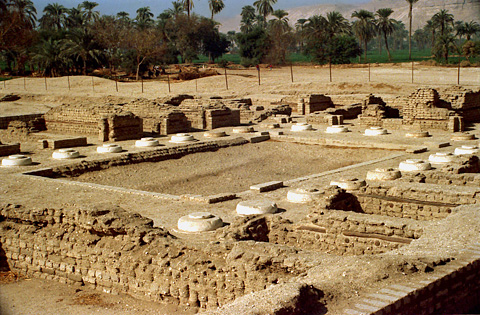
ruins at Amarna (Akhetaten), courtesy, EgyptSites.wordpress.com

Amarna is located on the eastern bank of the Nile in the modern-day province of Minya in central Egypt, some 194 miles south of Cairo, and 36 miles south of the provincial capital city of al-Minya. It is an extensive Egyptian archaeological site dating back to the Eighteenth Dynasty of ancient Egypt. Today, several, largely indigenous Coptic villages are located adjacent to, or around, the site: Deir Mawas, el-Tell, el-Hagg Qandil, Deir el-Bersha, Mallawi.
“Amarna” is actually Arabic, named after the Arab tribe that invaded and occupied the place. It was originally called “Akhetaten” by the ancient Egyptians meaning “horizon of the Aten” because it was built as the new capital city of the Pharaoh Akhenaten, dedicated to his new religion of worship to the Aten. Construction of Akhetaten started in or around Year 5 of his reign (1346 BC) and was probably completed five years later, during which time, it officially became the capital city. Most of the buildings were constructed out of mud-brick, and white washed. The most important buildings were faced with local stone.
It was laid out roughly north to south along a "Royal Road" – the further from the Road, the poorer the neighborhoods. The Royal residences were generally to the north, in what is known as the North City, with a central administration and religious area. The South City was made up of residential suburbs containing the estates of many of the city's powerful nobles, including Nakhtpaaten (Chief Minister), Ranefer, Panehesy (High Priest of the Aten) and Ramose (Master of Horses). This area also held the studio of the sculptor Thutmose, where the famous bust of Nefertiti, chief wife of Akhenaten, was found in 1912.
South of this area was Kom el-Nana, an enclosure, usually referred to as a sun-shade, and was probably built as a sun-temple. It was Akhenaten’s wish to have several temples of the Aten to be erected here, as well as for the royal tombs to be created in the area’s eastern hills for himself, Nefertiti and his eldest daughter Meritaten. The Maru-Aten, which was a palace or sun-temple was originally thought to have been constructed for one of Akhenaten's wives Kiya, but on her death her name and images were altered to those of Meritaten.
The city greatly declined during the reign of his son Tutankhamun, who began to reign two years after his father’s death. He decided to leave the city and return to his birthplace in Thebes, but Akhetaten seems to have remained active and a shrine to Horemheb indicates that it was at least partially occupied at the beginning of the reign of that Pharaoh, if only as a source for building material elsewhere.
After the death of Horemheb, the city was finally abandoned and remained so until Egypt came under Roman rule. Akhetaten revived and new settlements were established nearby along the edge of the Nile, namely, the villages of Deir el Bersha and Mallawi, both established directly across the river. When Christianity was introduced to Egypt, the local inhabitants adopted the new religion and their descendants have remained on that same spot since then.
During the early period of Christianity, several local churches and monasteries were established. In the 4th century, Saint Pishoy established his monastery, eventually named after him, in Deir is Bersha. This was part of a chain of monasteries he established throughout Egypt but when he died in 417, he was buried at the monastery in Bersha alongside his friend and fellow “desert father” Saint Paul of Tammah who died 2 years previously. However, some say it was his wish to be buried at one of the other monasteries he founded, specifically one located at Wadi el Natrun, in the north near the Nile Delta. In 841, his wish was carried out by Pope Joseph I who transferred his remains accordingly. Other churches that were prominent in Bersha include the Deir Abu Fam Tombs Coptic Orthodox Church, the Church in the Tomb of Urarna, and the Virgin Mary and Anba Abraam Coptic Orthodox Church (destroyed by Arabs in 2013).
For centuries thereafter, European explorers and archaeologists have occasionally covered the area but in 1887, a local woman digging for sebakh, decomposed mud brick, uncovered a cache of over 300 cuneiform tablets (now commonly known as the Amarna Letters). These tablets recorded select diplomatic correspondence of the Pharaoh and were predominantly written in Akkadian, the lingua franca commonly used during the Late Bronze Age of the Ancient Near East for such communication. This discovery led to the recognition of the importance of the site, and lead to a further increase in exploration. In 1891, a “dig house” was built by German archaeologist Ludwig Burchhardt as a storage base for artefacts recently discovered.
Since then, archaeologists have been making remarkable finds. They include: stelae dedicated to Isis and Shed, a cemetery of private individuals, the Royal Wadi, the North Riverside Palace, the Great Temple of the Aten, the Small Aten Temple, the ceremonial residence of the King and Royal Family, the Bureau of Correspondence of Pharaoh, the Boundary Stelae (each a rectangle of carved rock on the cliffs on both sides of the Nile) describing the founding of the city, the Royal necropolis, Workmen's village, Tomb of Akhenaten, Northern tombs, Southern tombs, Stelae U, Desert altars, Northern Palace, and Stelae H.


Wednesday, December 25, 2019

DURA EUROPOS

ruins of the Church House in Dura Europos, courtesy, Wikipedia
Dura-Europos is an ancient archaeological site of the Aramean Syriacs, the indigenous people of the area, located in, what is today, the southeastern part of Arab-occupied Syria near the west bank of the Euphrates River. Famous as the site of a 3rd century synagogue, in a remarkable state of preservation when discovered by archaeologists in the 1930s, the area is also home to other sites which pre-date the synagogue. Today, Dura Europos is located adjacent to the illegal Arab settlement of al-Salihiya. But religiously, it is under the jurisdiction of the Syriac Orthodox Church. Until the 11th century, the nearest church bishopric was at Circesium, 40 miles to the north.

Originally a fortress, Dura Europos was founded in 303 BC on Aramean Syrian land by settlers from, what is today, Greece and Macedonia in southeastern Europe, under Emperor Seleucus I Nicator, a former general in the army of Alexander the Great. The Greeks called the place “Dura”, located on the east-west and Euphrates trade routes. Indeed, Dura controlled the river crossing on the route between the newly founded cities of 
Antioch and Seleucia on the Tigris. Because of the city’s importance in location, it became a regional capital and a great caravan city and had close ties with nearby Palmyra. (The Palmyrene Gate was the principal entrance to the city.) Soon, the population became cosmopolitan and allowed for a co-mingling of cultural traditions. Aside from the original Greek and Syriac inhabitants, the general population was also made up of Romans, Israelites, Palmyrenes, Persians, and south Semitic peoples but the local social system continued to have the descendants of the original Macedonian/Greek settlers as the aristocracy. Even though the Greeks were eventually outnumbered by people of Semitic stock by the first century BC, and the city became eastern in character, this social system remained intact until the city’s abandonment in the middle of the 3rd century. The mix of populations was also reflected in the area's sacred architecture. For instance, by the 1st century, citizens from Palmyra, an important trade center, built temples to their gods Aphlat and Azzanathkona, and later (168-9) built the Mithraeum to honor the sun god Mithras. At the same time, citizens from nearby Anah built the Temple of Zeus Kyrios. In the first half of the 3rd century, the indigenous Syriacs built the Christian Church House, one of the oldest churches in the world outside of Israel. Inside of the church is the earliest known baptismal font as well as what is thought to be the earliest depiction of Jesus dating back to 235.
In 113 BC, the Parthians from Persia conquered the city, and held it, with one brief Roman intermission (114), until 165 when the Romans decisively conquered the city and built a military camp adjacent to it. The Romans added “Europos” to the city name because of its long-time European Macedonian/Greek aristocracy. Through an agreement with the new overlords, Dura Europos retained its status as regional headquarters for the section of the Euphrates between the Khabur and modern Abu Kemal and the local inhabitants would retain considerable freedom. In exchange the city’s military role was abandoned.  
In 256, Dura Europos was conquered by the Persian Sassanid Empire and the town was laid siege for a year. Most of the population was deported. The rest were marched off to Ctesiphon and there sold as slaves. Afterwards, it was bereft of any population at all and over time, the site was covered over by sand and mud and disappeared from sight.
Since then, the existence of Dura-Europos had long been known through literary sources. In 1885, it was rediscovered by the American "Wolfe Expedition" when the Palmyrene Gate was photographed by John Henry Haynes. British troops under Capt. Murphy in the aftermath of World War I and the Arab Revolt also explored the ruins. On March 30, 1920, a soldier digging a trench uncovered brilliantly fresh wall-paintings in the Temple of Bel. Afterwards, major excavations were carried out by French and American teams. Archaeological activity continued until renewed hostilities in the area caused the site to be closed. In 1933, excavations resumed. Sites uncovered included: the Temple of the Oriental Gods; the Temple of Adonis; the Temple of the Gadde; the Temple of Zeus Theos; and the Dura-Europos Route map, the fragment of a specialty map discovered in 1923.
Since 1986, joint excavations were established between French and Syrian Arab archaeologists under the direction of Pierre Leriche but the site was looted and mostly destroyed between 2011 and 2014 by the Islamic State during the Syrian Arab Civil War.

Tuesday, December 17, 2019

DJERBA

desert scene in Djerba, courtesy, galileo3000.si
The island of Djerba is, at 198 square miles, the largest island of North Africa, located in the Gulf of Gabès, and is politically, a part of Arab-occupied Tunisia. It is famous as the filming location of Star Wars which took place in and around the port of Ajim in the southwest corner of the island. Tourists can visit buildings featured in the original movie, including Obi-Wan Kenobi's house and the Mos Eisley cantina. The island is also famous for its ancient Jewish community and its indigenous inhabitants, the Amazigh (Berbers). Out of a total population of over 163,000, 15,000 belong to this indigenous community.
In ancient times, the Djerba Amazigh would often be influenced by the neighboring peoples from across the Mediterranean as well as the occupying empires that came and went throughout this period. Legend has it that Djerba was the island of the lotus-eaters where Odysseus was stranded on his voyage through the Mediterranean. The island, which was called Meninx until the third century AD, included three principal towns: one, known today as Būrgū, is found near Midoun in the center of the island; another, on the southeastern coast, which is as yet, unidentified, was a major producer of priceless murex dye, and is cited by Pliny the Elder as second only to Tyre in this regard; and the third was the ancient Haribus. The island was densely inhabited in the Roman and Byzantine periods, and probably imported much of the grain consumed by its inhabitants.
During the Middle Ages, Djerba was invaded and occupied by Arabs who followed the Ibadi form of Islam. They had a tremendous impact on the indigenous inhabitants who eventually became followers of this form of Islam. But since then, a slow process of Arabization set in forcing them to fight for their own cultural identity and rights. But in spite of this, there were also periods when the island came under indigenous rule, such as during the period of the Zirid dynasty of Sanhaja Berbers and that of the Hafsids who were Sunni Muslim Berbers. After the Hafsids expelled a garrison of Spanish soldiers from the island at the end of the 14th century, they built the Borj el Kebir Castle to the north of the town of Houmt Souk over the ruins of the ancient Roman city of Griba. In 1450, the castle was extended. In 1574, the Hafsids were overthrown by the Ottoman Turks and they, in turn, were overthrown by the French in the 19th century.  
After the French left Tunisia and Djerba in 1956, the process of Arabization resumed and so has the fight for Amazigh rights. The Amazigh have only been partially successful though. In general, many have lost aspects of their traditional identity. The Djerba Berber language called chilha, a language mainly derived from the ancient Zenata Berbers, is only spoken by some in the local villages, including Tlat, Ajim, Sedriane, Azdyuch, and Mahboubine. But only those in Sedouikech have learned to write it and the viability of chilha in the villages of Tlat and Ajim is tenuous with each passing generation. Only the elderly in these and other villages can speak it. They have ceased teaching their children due to its “difficulty”. Nowadays, the Djerba Amazigh speak Arabic and French and a minority learn other languages including English. Their clothing has also changed due to integration with the Arabs with many now wearing European-style clothing. In addition, radio, television, and the internet have taken hold of the younger generation.

On the other hand, the Amazigh of Guellala, Ouirsighen, and a minority of those from Sedouikech, have held on to their Amazigh identity and are proud of it. The Amazigh in Sedouikech work in commerce and especially in agriculture, producing quantities of olive oil. The inhabitants of Ouirsighen are considered well off with some living abroad, often in Europe, and sending back money to their families. Those of Guellala are well-known for their pottery, a profession that has been passed down from generation to generation. The town used to be home to hundreds of potters, but today only a handful can be seen busy at work in their workshops. With the passing of time, evolving material needs, and difficulty of the profession, the youth have begun to search for work in industrial and commercial locations. The town’s indigenous culture seemed on the verge of being forgotten. In response, the Guellala Museum was established on a hill overlooking the town as a depository of “Berberana”. The permanent exhibition includes a large collection of traditional tools and garments and everyday objects used in the past by the islanders. Also on display are life-size figures enacting scenes of everyday life like fishing, weaving and olive oil making, and also wedding ceremonies.

However, the interactions between men and women more closely follow the Arabian Bedouin tradition that came with their invasion and occupation of the area. As a result, men and women do not mix socially, and they continue to wear their traditional clothing.

There is a strong and close relationship between the island’s Amazigh and Jews. In the season of Jewish pilgrimage in Djerba the Amazigh ensure their safety. The Jews, for their part, consider the Amazigh trustworthy in commerce and business dealings.

A major geographical feature of the island is the Djerba Bin El Ouedian wetland and habitat for migratory birds. On November 7, 2007 the wetland was included on the list of Ramsar sites under the Ramsar Convention, due to its importance as a bird refuge.