For the record, I'm neither an academic nor a scholar, and admittedly, I've never been to many of the places posted here. So if someone should find a mistake, or believe I omitted something, please feel free to email me and I'll correct it.

I can be contacted at dms2_@hotmail.com.

Wednesday, February 12, 2020

EUPHRATES RIVER AND VALLEY

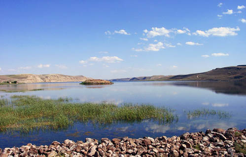
The Euphrates River in northern Syria. Photo by Ferrell Jenkins.
Euphrates River, northern Syria, courtesy, FerrellJenkins.blog
The Euphrates River could be described as the “Nile” of the Arab-occupied territory of Iraq and is mentioned in the Book of Genesis as one of the four rivers that sprang forth from the Garden of Eden. The Euphrates begins in the highlands of, what is today, eastern and southeastern Turkey, historically Armenian and Kurdish territories, and is formed by the confluence of the Kara Su and Murat Su Rivers. It continues through northern and eastern Syria and through central and southern “Iraq”, historically Kurdish and Assyrian territories. Towards its southern course, it joins the Tigris and finally empties into the northernmost coast of the Persian Gulf. This area is the traditional dwelling place of the so-called “Marsh Arabs”, descendants of the ancient Sumerians who called the river “Buranuna” according to cuneiform texts discovered in Shuruppak and Nippur and dated to the 3rd millennium BCE. It was also called “Purattu” in ancient Akkadian from where the Elamite name “U-ip-ra-tu-tish” derives, and “P’rat” in Syriac, “Frat” in Hebrew, and “Fira” in Kurdish. Together with the Tigris, it is one of the two defining rivers of Mesopotamia (the "Land between the Rivers").
The early occupation of the Euphrates basin was limited to its upper reaches. Acheulean stone artifacts have been found in the Sajur basin and in the El Kowm oasis in the central Syrian steppe; the latter together with remains of Homo erectus, were dated to 450,000 years ago. During the Jemdet Nasr (3600–3100 BCE) and Early Dynastic periods (3100–2350 BCE), southern Mesopotamia experienced a growth in the number and size of settlements. These settlements, including Sumero-Akkadian sites like SipparUrukAdab and Kish, were organized in competing city-states. Many of these cities were located along canals of the Euphrates and the Tigris that have since dried up, but can still be identified from remote sensing imagery. A similar development took place in Upper MesopotamiaSubartu and Assyria, although only from the mid 3rd millennium and on a smaller scale than in Lower Mesopotamia. Sites like EblaMari and Tell Leilan grew to prominence for the first time during this period.
During the period of the Akkadian (2335–2154 BCE) and Ur III Empires, large parts of the Euphrates basin were for the first time united under a single ruler which controlled – either directly or indirectly through vassals – large parts of modern-day Iraq and northeastern Syria. Following their collapse, the Old Assyrian Empire (1975–1750 BCE) and Mari asserted their power over northeast Syria and northern Mesopotamia, while southern Mesopotamia was controlled by city-states like IsinKish and Larsa before their territories were absorbed by the newly emerged state of Babylonia under Hammurabi in the early to mid 18th century BCE.
In the latter half of the 2nd millennium BCE, the Euphrates basin was divided between Kassite Babylon in the south and MitanniAssyria and the Hittite Empire in the north, with the Middle Assyrian Empire (1365–1020 BCE) eventually eclipsing the others. Following the end of this empire, struggles broke out between it and Babylonia over control of the Euphrates basin in Mesopotamia. The Neo-Assyrian Empire (935–605 BCE) eventually emerged victorious and also succeeded in gaining control of the northern Euphrates basin in the first half of the 1st millennium BCE.
In the following centuries, control of the wider Euphrates basin shifted from the Neo-Assyrian Empire (which collapsed between 612 and 599 BCE) to the short lived Median Empire (612–546 BC) and equally brief Neo-Babylonian Empire (612–539 BCE). Under King Nebuchadnezzar, the city of Babylon, capital of the Empire, became a marvel of the ancient world. Its walls and hanging gardens were considered one of the seven wonders of the world.
After the end of that empire, the Achaemenid Empire (539-333 BCE) took its place only to be overrun by Alexander the Great, who defeated its last Achaemenid king Darius III and died in Babylon in 323 BCE.
During this period, the river served as a border between Greater Armenia (331 BC–428 AD) and Lesser Armenia (the latter became a Roman province in the 1st century BCE). From 312-150 BCE, the region came under the control of the Seleucid Empire, the Parthian Empire (150–226 AD) (during which several Neo-Assyrian states such as Adiabene came to rule certain regions of the Euphrates), and was fought over by the Roman Empire, its succeeding Byzantine and Sassanid Empires (226–638 AD), and the Arab Islamic Empire which conquered the area in the mid-7th century.  
When the Assyrians and Armenians adopted Christianity in the first centuries CE, Assyrian and Armenian villages along the Euphrates grew and prospered and the town of Callinicum became the center of Christianity in the area. Bishop Damianus of Callinicum took part in the Council of Chalcedon in 451 and in 458 was a signatory of the letter that the bishops of the province wrote to Emperor Leo I the Thracian after the death of Proterius of Alexandria. In the early 6th century, Callinicum became a center of Assyrian monasticism with Dayra d'Mār Zakkā, or the Saint Zacchaeus monastery, situated on Tall al-Bi'a, achieving a degree of renown. It is mentioned by various sources up to the 10th century. Under its Bishop Ioannes in the mid-6th century, a Notitia Episcopatuum listed the diocese as a suffragan of Edessa, the capital and metropolitan see of Osrhoene. The second-most important monastery in the city was the Bīzūnā monastery or Dairā d-Esţunā, the 'monastery of the column'.
In the year 639 or 640, Callinicum surrendered to the Muslim conqueror Iyad ibn Ghanm. At the surrender of the city, the Syriac Christian inhabitants concluded a treaty with Ibn Ghanm which allowed them freedom of worship in their existing churches but forbade the construction of new churches. The city retained an active Christian community well into the Middle Ages (Michael the Syrian records 20 Syriac Orthodox (Jacobite) bishops from the 8th to the 12th centuries). In the 9th century, when Callinicum, now Raqqa, served as capital of the western half of the Abbasid Caliphate, Saint Zacchaeus Monastery, became the seat of the Syriac Orthodox Patriarch of Antioch, one of several rivals for the apostolic succession of the Ancient patriarchal see. In the 12th century, the town experienced a second revival under the rule of the Kurdish Ayyubid dynasty.
There was also a Christian monastery in Deir ez Zor called Monastery of the Hermits. Today, it is the Omari Mosque. During the early Arab period, Muslims had colonized Deir ez-Zor having come from Iraq and other countries, because of its good location. Eventually, the indigenous Christians were forced to leave and those who didn’t, were forced into Islam.
In the early 9th century, the Byzantine city of Rumkale (today in Turkey) was occupied by various Byzantine and Armenian warlords and in the 12th century, it also became the seat of an Armenian bishop. In 1179, a synod took place in the town, which attempted a compromise between the Greeks and Armenians. From 1203 to 1293, it served as the residence of the Catholicos of the Armenian Church. In the 14th century, the town of Anah was the seat of the catholicos who served as primate over the Persian Christians.
After the earthquake in 1157, the town of Mayadin was granted by the Turkish Zengid ruler Nur ad-Din to Asad ad-Din Shirkuh, a Kurd and paternal uncle of future Ayyubid sultan, Saladin. Shirkuh relocated the town’s fortress about 2.5 miles southwest of the original site. The new settlement, known as "al-Rahba al-Jadida", remained the significant center of the Euphrates region through much of the AyyubidMamluk era (12th–15th centuries). The ruins of the fortress can still be seen to this day.
After the destructive onslaughts of the Mongols on the Euphrates Valley centers in the 15th century, a few families of Arabs and Kurds began to resettle in the area, especially in and around Callinicum and thus, the modern town of Raqqa was born. The Kurdish clans banded together and called themselves “al-Akrad”, the Kurds. The Kurds of the Mîlan tribe of the Nahid Al-Jilab region have been present in Raqqa since 1711 but most left and returned back to their original homes after only a short while. Some Kurdish families were displaced to the northern countryside of Raqqa as a result of forced taxation by the Arab 'Annazah tribe. At the same time, the diocese of Callinicum was nominally restored as the Latin Titular bishopric of Callinicum. The town became a center of Maronite Christianity and in 1729, the Italian-born Mathaeus de Robertis was appointed its first Maronite bishop.
During the 19th century, there were many Christian communities of Assyrians, Maronites, Greeks, and Armenians, throughout the Euphrates Valley as well as many Kurdish communities. Since the 1840s, the Christians would suffer severe persecutions and massacres at the hands of their Muslim neighbors, mainly the Turks, but also by the Kurds who were promised glory if they were allied with the Turks, but in the end, were also persecuted and massacred. In 1895, the town of Birecik became one first sites of atrocities of Turks against Armenians during the Hamidian Massacres, the first in a series of massacres that would become the Armenian Genocide. By the beginning of World War I in 1914 the Ottoman Empire began systematic campaigns to kill and displace Armenians who were forced to undergo death marches in the desert which were designed to lead to the death of the deportees.
Deir Ez Zor was the last destination of the forced displacement and the scene of killings and slaughter by the Turkish gendarmerie. It was here that the Ottoman authorities planned to use the local Arab population for the final extermination. But their plans failed. The Arabs, under their mayor Haj Fadel Al-Aboud actually protected them instead. Therefore, it was actually the local Arabs who saved many Armenian lives that day and thus was established good relations between the two peoples.
When the war ended, researchers estimated the number of Armenian victims as between 1 million and 1.5 million plus another 300,000 Assyrian victims. After the war, Assyrians from Iran settled in the city of Habbaniya which soon became an Assyrian Christian center.
Deir ez Zor has since become a pilgrimage destination for hundreds of thousands of Armenians on April 24 each year, after being declared as such in 2002 by Catholicos Aram I. The city is also home to the Armenian Genocide Memorial Church which was officially built in 1991, and the Deir ez-Zor Museum which keeps thousands of antiquities collected from nearby archaeological sites in Northern Mesopotamia. Deir ez-Zor is also home to the third Armenian diplomatic mission in Syria; the Honorary Consulate of Armenia, opened on February 11, 2010.
The Euphrates receives most of its water in the form of rainfall and melting snow, resulting in peak volumes during the months April through May. Discharge in these two months accounts for 36 percent of the total annual discharge of the Euphrates, or even 60–70 percent according to one source, while low runoff occurs in summer and autumn. The discharge regime of the Euphrates has changed dramatically since the construction of the first dams by the Turkish and Arab occupation authorities in the 1970s. With the enthusiastic support of the United Nations, the dams have affected 382 villages, and almost 200,000 people have been resettled elsewhere. The largest number of people was displaced by the building of the Atatürk Dam, which alone affected 55,300 people. The flooding of Lake Assad led to the forced displacement of about 4,000 families, who were resettled in other parts of northern Syria as part of a now abandoned plan to create an "Arab belt" along the borders with Turkey and Iraq.
The inundation of large parts of the Euphrates valley has also led to the flooding of many archaeological sites and other places of cultural significance. Although concerted efforts have been made to record or save as much of the endangered cultural heritage as possible, many sites are probably lost forever. The flooding of Zeugma with its unique Roman mosaics by the reservoir of the Birecik Dam has generated much controversy in both the Turkish and international press. The construction of the Tabqa Dam in Syria led to a large international campaign coordinated by UNESCO to document the heritage that would disappear under the waters of Lake Assad. Archaeologists from numerous countries excavated sites ranging in date from the Natufian to the Abbasid period, and two minarets, but not a single Christian or pre-Christian structure, were dismantled and rebuilt outside the flood zone. Important sites that have been flooded or affected by the rising waters of Lake Assad include MureybetEmar and Abu Hureyra. A similar international effort was made when the Tishrin Dam was constructed, which led, among others, to the flooding of the important Pre-Pottery Neolithic B site of Jerf el-Ahmar. An archaeological survey and rescue excavations were also carried out in the area flooded by Lake Qadisiya in Iraq. Parts of the flooded area have recently become accessible again due to the drying up of the lake, resulting not only in new possibilities for archaeologists to do more research, but also providing opportunities for looting, which has been rampant elsewhere in Iraq in the wake of the 2003 invasion.

Sunday, January 26, 2020

VALLEY OF ESHCOL

grapes
supposed location of the Valley of Eshcol, courtesy,
ACallToTheRemnant.com
The Valley of Eshcol, located on the outskirts of Hebron in the Judean Desert, is formed by the brook of the same name. It occupies an important place in Jewish history. In Biblical times, the area was probably named after Eshcol, the owner of the land and, along with his brothers Mamre and Aner, was an ally of Abraham. According to Genesis 14:13-24, they had joined forces with those of Abraham in pursuit of king Chedorlaomer and his armies who had taken Abraham's nephew Lot and others as captives.

Many years later, during the period of the exodus from Egypt, the Children of Israel camped in the Wilderness of Paran, today in the central Negev Desert just south of the Judean Desert, and from there, Moses sent twelve spies to spy out the Promised Land and bring back a report. Two of the spies made their way to this valley and, along with some pomegranates and figs, also brought back a cluster of grapes hanging on a pole carried by the two as proof of the fruitfulness of the land. Soon, the name “Eshcol” became the Hebrew word for “cluster”.

Today, scholars and historians disagree as to where the Valley is actually located, but there seems to be a consensus that it might be a wadi, known in Arabic as “Wadi Tuffah”, just to the north of historic Hebron and in the vicinity of the neighborhood of Mamre, where Abraham pitched his tent. Part of the neighborhood is now, an archaeological site called “Elonei Mamre” and is in fact, bordered on the north by various wadis that are either terraced or flat farmland. Throughout the Middle Ages into the Modern Era though, travelers, including Benjamin of Tudela, the 12th century Jewish traveler from Spain, would describe an abundance of grape vines in this area. American archaeologist Edward Robinson in the 1830s described these grapes as the largest in the Land of Israel. But on the other hand, in 1850, the Jewish scientist and rabbi Yehoseph Schwarz visited the area west of Hebron known as “Wadi Azarar” and declared it to be the actual Valley of Eshcol.   

Today, the areas to the north and west of Hebron are Arab-occupied areas within the municipal boundaries of Hebron. It is also surrounded by hostile Arab settlements that were established in the last century due to the influx of Arab migrants that suddenly expanded the city without any regard to its Biblical and historic character. Consequently, any concrete clues to the exact location of the Valley were summarily obliterated.

Sunday, January 19, 2020

VALLEY OF JEZREEL

Valley of Jezreel, Israel, courtesy, Wikipedia
The Jezreel Valley, also known as the Valley of Megiddo or the Plain of Esdraelon, is a large fertile plain and inland valley in northern Israel formed by the Kishon River. It takes its name from the ancient city of Jezreel which was located on a low hill overlooking the southern edge of the valley. The name “Jezreel” is of Hebrew origin and means "God sows", aptly named since the valley has become known as the breadbasket of Israel. It is bordered to the north by the highlands of the Lower Galilee region, to the south by the Samarian highlands, to the west and northwest by the Mount Carmel range, and to the east by the Jordan Valley, with Mount Gilboa marking its southern extent. Today the largest city in the valley is the Arab Muslim/Christian city of Nazareth which lies near its center. In Christian eschatology, the Final Battle between the forces of Gog and Magog, good and evil, will be fought at the site of Har Megiddo – Mount Megiddo, near the village of the same name. Centuries later, the name of this site became Latinized to “Armageddon”.
In the Biblical period, the Jezreel Valley partly covered the Israelite territories of Asher, Menasheh, Zvulun, and Yissasschar. During the rule of the Prophetess Deborah, a major battle occurred at Mount Tabor, in the eastern part of the valley, between the Israelites under Barak and the Canaanites under Sisera. The valley was also the scene of a victory by the Israelites under Gideon, against the Midianites, the Amalekites, and the Children of the East (Judges 6:3), but was later the location at which the Israelites, led by King Saul, were defeated by the Philistines at Mount Gilboa (1 Samuel 28:4, 29:1–29:6, 31:1-31.6). During the period of the Divided Kingdom, Jehu, an army captain of the northern Kingdom of Israel, killed King Jehoram in the valley, and had Jezebel killed in Jezreel town (2 Kings 9:1-9:10).
After the Roman destruction of Jerusalem and due to subsequent invasions and counter-invasions in the following centuries, the area gradually lost its population and by the 13th century, after the Crusader period, it was largely deserted, became a swampland, and abandoned to nomads. However, the edges of the valley, namely villages like Bet Shean were still populated, mainly by Muslim Arab settlers but also by some Jews who remained. The 14th century topographer Ishtori Haparchi settled there and completed his work Kaftor Vaferach in 1322, the first Hebrew book on the geography of Palestine. But in the main, the valley remained swampland which bred malaria making settlement impossible. In the 1870s, the Sursock family, a Greek family in Beirut purchased 80,000 acres of valley land from the Ottoman government for approximately £20,000. In 1910, Yehoshua Hankin completed his first major Jewish purchase in the Jezreel Valley. He bought some 10,000 dunams of land in the area of Al-Fuleh (now Afula), which became the home of two moshav settlements, Merhavia in 1911 and Tel Adashim in 1913. Afula itself, was then an Arab hamlet that was also home to a small Jewish community. By 1924, this community had grown sufficiently and was able to establish the Emek Medical Center which served the entire region. By the 1920s, Nazareth also had a Jewish population (see article on Nazareth). Between 1912 and 1925 the Sursocks sold part of their landholdings to the Jewish National Fund which established Nahalal, the 1st large moshav, in 1921, and part to the American Zion Commonwealth which purchased Afula in 1925. The Jewish farmers who settled on the land, set about the task of draining the swamps to enable further land development.
In the late 1920s, a synagogue mosaic was uncovered by archaeologists at Bet Alfa. (see Bet Alfa and Synagogue). Valley sites established during the British Mandate period included: Ginnegar, Balfouria (1922), Mizra, Kfar Gidon (1923), Gevat, Ramat David, Bet Shearim, Bet Zaid, Kfar Baruch (1926), Kfar Yehoshua, Sde Yaacov (1927), Kfar Hahoresh (1933), Alonim (1938), Dovrat (1946), and Gazit (1947).
During the Arab riots in the 1930s, Bet Shean served as a base for Arab attacks against Jews whether they were immigrants or not. Throughout the centuries, Jews have live in Bet Shean, on and off, but during the riots, the Arabs finally expelled them. During this time, the settlement of Tel Amal was established as a Tower and Stockade settlement for the purpose of defense against Arab attacks. Today, it is part of Gan Hashlosha National Park, one of the most popular recreation areas in Israel. After Israeli independence, development of the valley increased in pace. In 1954, Kibbutz Yifat was established. It houses the Museum of the Beginning of Settlement and contains exhibiting items and photos of the pioneer settlement in Israel. Max Stern Yizreel Valley College, located between Afula and Nazareth, was founded in 1965 and offers BA degrees and holds courses in such fields as EconomicsBehavioral SciencesSocial SciencesCommunication Studies, Human Services, Health AdministrationNursing Studies and General Studies. In 1980, the Jezreel Valley gained regional status and the Jezreel Valley Regional Council was established in Nahalal. In 2006, the Israeli Transportation Ministry and the Regional Council announced plans to build an international airport near Megiddo but the project was shelved due to environmental objections.

Saturday, January 4, 2020

EILAT

Eilat night hotels 2016.jpg
Eilat, courtesy, Yigal Dekel / Wikipedia
Eilat is Israel's southernmost city, a busy port and popular resort at the northern tip of the Red Sea, along the Gulf of Eilat. With a population of approximately 52,000, the city is considered a destination for domestic and international tourists. Eilat is part of the Southern Negev Desert, at the southern end of the Arava plains, almost adjacent to the Sinai village of Taba to the south, the Jordanian port city of Aqaba to the east, and within sight of Haql, Saudi Arabia, across the gulf to the southeast. Aside from the Arava, the city is surrounded on the north, by the Eilat Mountains which can rise up to 2,900 feet above sea level. To the south, lies Eilat’s seashore. Eilat is first mentioned in the Tanakh in the Book of Exodus. The areas in and around the city served as one of the stopping stations surrounding the Promised Land for the Israelites after they left Egypt.
Thousands of years ago, before the coming of the Israelites, the site must have been covered in pistacia trees since the name “Eilat”, in all probability, derives from the Hebrew word Elah meaning Pistacia tree. However, due to its geographic location, the city of Eilat wasn’t even supposed to exist. There was nothing in the area to maintain and sustain a sizable population. But according to archaeologist and historian Uzi Avner, "The main elements that influenced the region's history were the copper resources and other minerals, the ancient international roads that crossed the area, and its geopolitical and strategic position. These resulted in a settlement density that defies the environmental conditions." Indeed, archaeological excavations have uncovered impressive prehistoric tombs dating back to the 7th millennium BCE at the western edge of Eilat which implied a well-to-do populace.
When King David conquered Edom, he also took over Eilat, the border city shared by both Israel and Edom. The commercial port city and copper based industrial center were, however, maintained by Egypt, until reportedly rebuilt by Solomon at an adjacent location known as Etzion-Gever (I Kings 9:26). Solomon also built a "navy of ships" at Etzion-Gever from where it sailed to Ophir manned by his servants and those of Hiram, king of Tyre (i Kings 9:26; i Chron. 8:17). It was a prosperous Judean trading port from the 9th through 7th centuries BCE. In 2 Kings 14:21–22, many decades later, "All the people of Judah took Uzziah, who was sixteen years old, and made him king in the room of his father Amaziah. He rebuilt Elath, and restored it to Judah, after his father's death." Later, in 2 Kings 16:6, during the reign of King Ahaz: "At that time the king of Edom recovered Elath for Edom, and drove out the people of Judah and sent Edomites to live there, as they do to this day."
Israelites/Jews continued to live in Eilat, however, for centuries thereafter. In the period preceding the Arab invasion in the 7th century, delegations were sent to conclude protective treaties with Muhammad, once his fame had begun to spread, and included Jews from Eilat who were accompanied by Jews from the neighboring communities of Adhruh and Jarbā, between Petra and Maān in what is today, Arab-occupied Jordan. But treaties notwithstanding, Muhammad began to kill or expel the Jewish tribes from Arabia, with many finding refuge in Eilat, particularly in the neighborhood of Aila (today, lying in Jordan). The Jewish community, and the town in general, continued to exist until the middle of the tenth century or possibly until the Crusader period beginning in 1099 when the area was destroyed and became deserted and in ruins. It remained in this state since then, with the exception of the occasional mud hut.
The Port of Eilat had its beginnings in 1947, which probably allowed the area to be designated as part of the Jewish state in the UN Partition Plan. During the War of Independence against Arab invaders and terrorists, the Israeli army consolidated control over Eilat as part of Operation Uvda. This happened without a fight, and there, occurred the famous raising of the Ink Flag on the site. After the war, the Arab countries maintained a state of hostility with Israel. In the first half of the 1950s, the Arabs of Egypt would often close the Straits of Tiran, the oceanic passage way to Eilat, to Israeli shipping and foreign shipping bound for Israel thus, hampering the local economy.
Despite all this though, construction of the city began shortly after the war. A first step in establishing a civilian settlement was made in December 1949 when members of the Ha-Kibbutz ha-Me'uḥad movement set up a temporary camp on the Eilat shore. An airport was opened the same year (it closed in 2019). The first water pipeline to Eilat was laid in 1952. A concerted effort by the Israeli government to develop Eilat began in 1955 when Jewish immigrant families from Morocco were resettled there. During this phase of development, a few services established for excursionists, experimental coastal fishing, and mineral exploration provided the inhabitants' principal occupations.
However, as long as the Straits were closed, Eilat's growth was extremely slow. The port area became vital to Israel’s development, not only as regards to oil imports, but also for communications, commerce, trade, and other interactions with the countries of Africa and Asia. In addition, the Arabs of Egypt also denied passage through the Suez Canal to any ship with an Israeli connection. In 1956, their final closure of the Straits of Tiran to Israeli shipping effectively blockaded the port of Eilat leading to Israel's participation alongside Britain and France in war against Egypt. This became known as the Suez Crisis. In the aftermath, Israel liberated the Sinai Peninsula thus opening up the Straits, and Eilat began to develop rapidly. But Prime Minister Ben Gurion allowed the international community to pressure Israel to give up the Sinai Peninsula immediately after the war and return it to Egypt. UN troops would take over security matters – at the discretion of the Egyptian Arabs.  
Eilat developed rapidly after the war though. In 1957 the Eilat–Mizpeh Ramon–Beersheba road was built, and opened to traffic the next year. The original port anchorage was repeatedly enlarged to cope with the mounting sea cargo traffic, and an oil port was installed in the southwest of the city. The first 16 in. oil pipeline connecting Eilat with Haifa was laid in 1958/59. A new port was built at an investment of $5.7 million and opened in 1964. In 1965, a thermal distillation plant was opened, which simultaneously supplied electricity to the town.
In 1967, the Egyptian Arab army returned to the Sinai with the UN’s blessing, and the Straits of Tiran were closed again. Oil tankers that were due to pass through the straits were delayed. The Six Day War led to the opening up of the Straits once again as well as the re-liberation of the Sinai. Even though Arab saboteurs made numerous attempts to attack the city, development resumed. Mineral exports (potash, phosphates, copper) through Eilat increased in 1966/67. The Eilat Ashkelon Pipeline was laid in 1968. The city’s airfield was enlarged and daily flights connected it with Tel Aviv and Jerusalem. In 1974, the Lotar Eilat special unit was formed especially for the defense of the city. Tourism was the main reason for the great Eilat shoreline project with its numerous hotels and artificial lagoons and land tongues. Following peace treaties signed with Egypt in 1979 when Israel was, once again, forced to give up the Sinai, and Jordan in 1994, Eilat's borders with its neighbors were finally opened allowing many affluent Arabs from Jordan and Egypt to visit Eilat in the summer months as well as allowing Israelis to depart Eilat for the Sinai or Aqaba. To encourage tourism further, the city became a free trade zone in 1985 and also received a VAT exemption that same year. In 2007, over 200 Sudanese refugees who arrived in Israel illegally on foot were given work and allowed to stay in Eilat.
Every year Eilat hosts two major cultural events: a jazz festival and a classical music festival with international participation. Eilat has been utilized by film and television productions - domestic and foreign - for location shooting since the 1960s, most notably in the early 90s as a tropical locale for season 2 of the Canadian production Tropical Heat. It was also used in the films She, Madron, Ashanti and Rambo III.
Two major terrorist incidents occurred in Eilat in recent years: the 2007 Eilat bakery bombing which killed three civilian bakers, and the 2011 southern Israel cross-border attacks when terrorists infiltrated from the Sinai. In response, Israel has built the Israel-Egypt barrier, a steel barrier equipped with cameras, radar and motion sensors along the country's southern border. The fence was completed in January 2013.
Sites of interest in and around Eilat include:
The Egyptian temple of Hathor; King Solomon's Pillars sandstone formation; the Eilat–Sedom highway put into use in 1967; the Eilat-Sharm el Sheikh road constructed in 1969; the Yoseftal Medical Center, established in 1968, Israel's southernmost hospital, and the only hospital covering the southern Negev; the Marine Museum; the Hesder Yeshiva Ayelet Hashachar, established in 1997; the Eilat Sports Center, a $3 million project, completed in 2013; the SPNI's Eilat Field School on the outskirts of Eilat offers special hiking tours that focus on desert ecology, the Red Sea, bird migration and other aspects of Eilat's flora and fauna; the Birdwatching and ringing station; the International Birding & Research Center; the Coral Beach Nature Reserve, an underwater marine reserve of tropical marine flora and fauna; the Coral World Underwater Observatory, the largest of its kind in the Middle East, located at the southern tip of Coral Beach, has an aquaria, a museum, simulation rides, and shark, turtle, and stingray tanks; Dolphin Reef, a marine biology and research station where visitors can swim and interact with dolphins; the Marina, with some 250 yacht berths; "What's Up", a portable astronomical observatory with programs in the desert and on the promenade; the Ice Mall which contains an ice skating rink and shopping mall; Eilat City Museum; Eilat Art Gallery.