For the record, I'm neither an academic nor a scholar, and admittedly, I've never been to many of the places posted here. So if someone should find a mistake, or believe I omitted something, please feel free to email me and I'll correct it.

I can be contacted at dms2_@hotmail.com.

Friday, July 3, 2020

JERUSALEM CORRIDOR (PROZDOR YERUSHALAYIM)

landscape, Jerusalem Corridor region, courtesy, Wikipedia
The Jerusalem Corridor is a mountainous geographical district in Israel stretching from Jerusalem on the east to the Shephelah on the west. The largest towns in this area are Beit ShemeshMevasseret ZionAbu GhoshTzur Hadassah and Kiryat Ye'arim (the Biblical Beth Yearim). Today, the Corridor comes under the jurisdiction of the Mateh Yehuda Regional Council.
In Biblical times, this area straddled the border between the Israelite tribal territories of Judah and Dan. Several major Biblical events occurred here. The town of Zorah was the birthplace of the judge Samson who, according to the Biblical narrative, began to be agitated by the Spirit of God in the locality of Mahaneh Dan (the camp of Dan), the district "between Zorah and Eshtaol" (Judges 13:25). After his death in Gaza, Samson's body was brought back for burial in the tomb of his father Manoah between Zorah and Eshtaol (Judges 16:31).
The city of Beit Shemesh was set aside as one of the 13 Kohanic cities for the priests of the tribe of Levi. It is also mentioned in the Book of I Samuel as being the first city encountered by the Ark of the Covenant on its way back from Philistia after having been captured by the Philistines in battle (1 Samuel 6:12-21). Afterwards, it was transferred to the nearby town of Beth Yearim where it remained for about 60 years. In the meantime, David fought Goliath in the Valley of Elah. When he became king of Israel, he transferred the Ark from Beth Yearim to Jerusalem, his capital. In 2 Kings 14, Beit Shemesh is again mentioned as being the site of the battle between King Amaziah of the southern Kingdom of Judah and King Jehoash of the northern Kingdom of Israel. In 701 BCE, Sennacherib, ruler of the Assyrian Empire, destroyed much of Judah resulting in the abandonment of Beit Shemesh, but there seems to have been a later attempt by a group of Judahites at resettling the city, judging by the archaeological discovery of the refurbishing of the water reservoir. In 586 BCE, at the start of the Babylonian Captivity, the inhabitants of Beit Shemesh were exiled. After the Captivity and during the Second Temple period, there was no lasting revival of the city, as opposed to many other places in the vicinity such as Beit GuvrinMaresha, and others.
The Jerusalem Corridor also figures prominently in the New Testament as the location of Beth HaKerem, the birthplace of John the Baptist and the abode of his parents Elizabeth and Zechariah, according to Christian tradition. This town was renamed as Ein Karem under the Arab occupation in the 7th century. Al-Tamimi, the Arab physician (d. 990), mentions an old custom of the Jews of Ein Karem to make wreaths from the boughs (branches) of a wild plant belonging to the mint family (Lamiaceae) during the Jewish holiday of Shavu'ot.[22]
Since the destruction of Jerusalem in 70, there were still many Jewish villages in the Corridor but their numbers eventually and dramatically declined. When the Spanish Jewish traveler Benjamin of Tudela visited the area in c. 1173, he noted a small Jewish community remaining in Beth Guvrin. Jewish pilgrims often traversed the area along the ancient road stretching from Jaffa to Jerusalem. But beginning in the early 16th century, the Abu Ghosh clan from the town of the same name, would often demand a toll from pilgrims regardless of faith. Soon after, the Land of Israel came under the control of the Ottoman Empire but molestation of pilgrims continued. In 1827, Sir Moses Montefiore made his first visit to Israel and travelled on this road. In his diary, he explicitly stated that he was never molested for a toll. In the course of the 19th century, when reforms began to be implemented in the Ottoman Empire, a proper road was constructed on the pilgrimage route (today, the Tel Aviv-Jerusalem Highway (Highway 1)) and a khan was built at Shaar Hagai in 1867 for the accommodation of travelers. It was managed by several Jewish families since its foundation.
In 1854, farmland was purchased from the Arab village of Qalunya (today, Mevaseret Zion) by a Baghdadi Jew, Shaul Yehuda, with the aid of the British consul in Jerusalem James Finn. Thus, the Jewish village of Motza was founded and the first 4 families began to settle there. One established a tile factory which was one of the earliest industries in the region. In 1871, a travelers’ inn was also established. When Theodor Herzl visited Palestine in 1898, he passed through Motza, which then had a population of 200. Captivated by the landscape, he planted a cypress tree on a hill. After he died in 1904 at age 44, it became an annual pilgrimage site by Zionist youth, who planted more trees around Herzl's tree.
In the early 1870s, the Spanish consul in Jerusalem, Alexander Spanoli, bought over 5,000 dunams of land from the Arab villagers of Artuf, which was then sold to the London Society for Promoting Christianity Amongst the Jews. After the pogroms against the Jews in Eastern Europe in 1882, the Society embarked on a fundraising mission, and then used some of the money raised to help Jewish refugees purchase some of its land. Towards the end of 1883, 24 families were settled there, each receiving 150 dunams of farmland, farm animals and tools. But due to economic difficulties and the lack of water, some of the land was leased to Arabs. The Society was still involved in the village’s life though, and the Jewish residents were obliged to attend Sunday meetings and send their children to the missionary school, but there were no instances of outright religious coercion. Most of the residents remained practicing Jews. In 1895, the Bulgarian Hibbat Zion movement bought the 5,000-dunam farm from the London Jews Society and renamed it Har-Tuv (lit. Mountain of Good). Twelve Jewish families settled there and tried to earn a living from agriculture. In 1900, one of the residents inaugurated a carriage service to Jerusalem.
In the following years, other Jewish communities were founded. The village of Kfar Uria was established in 1912 and served as an agricultural training place. Many of the local Arabs were on good terms with the people who lived there and had treated the moshav's association director, Baruch Yakimovsky, as their mukhtar (village chief) as he was on amicable terms with mukhtars in surrounding villages. The farmers of the area, both Jews and Arabs, cooperated and defended each other against raiding nomadic Bedouin. During this time, the leaders of Abu Ghosh decided to work together with the Jews and were also on friendly terms with the Zionist leaders. In 1912, the land on which kibbutz Kiryat Anavim stands, was purchased from the village by Arthur Ruppin, head of the Zionist Organization’s Palestine Office in Jaffa. In 1919 a group of 6 pioneers from the Ukrainian town of Kaminiz Podolsk and Preluki settled there, near a small spring called "Dilb" so-called for the surrounding plane trees. Twenty more arrived there in the spring of 1920 when Zionist leader Chaim Weizmann visited Palestine and was hosted by the residents of Abu Ghosh. Ramat Rahel was established in 1926 by members of the Gdud HaAvoda labor brigade.
In the 1929 Arab riots, most of the Jewish communities in the area, like many nationwide, were attacked and destroyed, often by Arabs from outside the area, resulting in the killing or expelling of the inhabitants. In the early 30s most of the Jewish refugees were able to return home. Hartuv and Ramat Rahel were rebuilt in 1930, as was Kfar Uria whose inhabitants were saved by their Arab neighbors. But in Kfar Uria, settlement was intermittent especially during the resumption of the Arab riots in 1936-1939. It was only settled permanently in 1944 by Jewish stonecutters from Kurdistan. In 1933, Motza Ilit was established near site of the original destroyed community where many had been massacred and the corpses burned.
The kibbutz Maale Hahamisha was founded by members of the Gordonia youth movement on July 19, 1938 as one of 57 strategically-placed tower and stockade settlements founded during the 1936-1939 Arab riots in order to defend the surrounding Jewish communities against Arab attacks. It was named after five men ambushed and killed by Arab gunmen nearby. In 1946, the land on which Neve Ilan is located was purchased by the Jewish National Fund from an effendi  landowner from Abu Ghosh at the urging of David Ben-Gurion in order to establish a "Kibbutz Army Post" to defend the Jerusalem road. The initial 31 settlers were 17 young men and 14 young women, mostly Jewish immigrants from France. Shortly aftereward, six hundred dunams of modern-day Kiryat Ye'arim were purchased by Menashe Elissar, a businessman who was attracted to the site as the location of the biblical Kiryat Ye'arim.
At the end of November 1947, considered the beginning of Israel’s War of Independence, the road to Jerusalem was cut off and the Arabs began to besiege the city’s Jewish neighborhoods. On the other side of the Corridor, the area from Neve Ilan to Hulda, was under their control allowing them to dominate the hilltops overlooking Bab al-Wad all the way to the Neve Ilan plateau. In the meantime, Arabs and Jews fought for control of the Arab fortress settlement of al-Qastal, which overlooked the main Tel Aviv-Jerusalem highway and from where Jewish motorists were routinely ambushed. Al-Qastal exchanged hands several times in the course of the fighting until the Arab commander Abd al-Qadir al-Husayni was killed. Many of the Arabs left their positions to attend al-Husayni's funeral at the Al-Aqsa Mosque on Friday, April 9. That same day, al-Qastal fell to the Yishuv forces, virtually unopposed. Later that month, a battle occurred at Deir Yassin which was especially intense, but Irgun and Palmach fighters liberated that too, at great cost. Unfortunately, many innocent civilians were also killed. News reports in the Arab press described it as a deliberate massacre and the Arab masses believed it without question. It has remained a sore point with them ever since. 
On May 8, Palmach fighters, as part of Operation Macabee, gathered at Neve Ilan in preparation for an attack on the village of Saris, and the western approach to Bab al-Wad. After heavy fighting, that road was finally liberated. Shortly afterward, in order to lift the siege on Jerusalem, the Burma Road was built, under Arab fire. It helped to bring necessary supplies to the Jews in Jerusalem and in October, Israeli troops, in Operation HaHar, finally brought the entire area under their control.
After the War, Ma'ale HaHamisha took in refugees from Gush Etzion, the area of which, had come under Arab occupation. Beginning in 1950, many new Jewish communities were established in the Corridor, many on earlier Biblical Israelite towns. A local re-afforestation project also began spearheaded by the Jewish National Fund. On December 6, 1950, the Hartuv displaced persons camp "Ma'abarat Har-Tuv" was established on the site of the current-day Moshav Naham. Its first inhabitants were Bulgarian Jews. They were soon joined by other Bulgarian Jews as well as those from IranIraqRomaniaMorocco and Kurdistan. In its early years, Beit Shemesh came to typify the "Development Town" with a largely North African population. Maoz Zion ("Stronghold of Zion") was established in 1951 to house new immigrants from IraqKurdistan, North Africa and Iran who had been living in a ma'abara at the foot of al-Qastal. Many were employed at the nearby Solel Boneh stone quarry. Tzur Hadassah was established in 1956 as a regional center for nearby moshavim such as Bar GioraMataMevo Beitar and Nes Harim. It was named for the Hadassah organization. Also in 1956, Neve Ilan was disbanded and vacated, due to economic and social problems but in the late sixties, the Young Judeans in America sent a group to establish an industrial village. The members arrived in early 1970, and moved into the homes built by the Jewish Agency, and the settlement was re-established as a moshav in 1971.
Today, in addition to the Jerusalem – Tel Aviv highway (Highway 1), a number of additional routes lead to Jerusalem; Route 443 which covers the northern part of the corridor; Route 395 leads from Ein Kerem to the coast, via Ramat Raziel and Bet Shemesh, and continues south; Route 386 leads to the Ella Valley, via Bar Giora and Tzur Hadassa. A railway line is also active in the corridor, next to the Sorek Stream, which is part of the historical Jaffa–Jerusalem railway.

Sunday, June 28, 2020

JERICHO

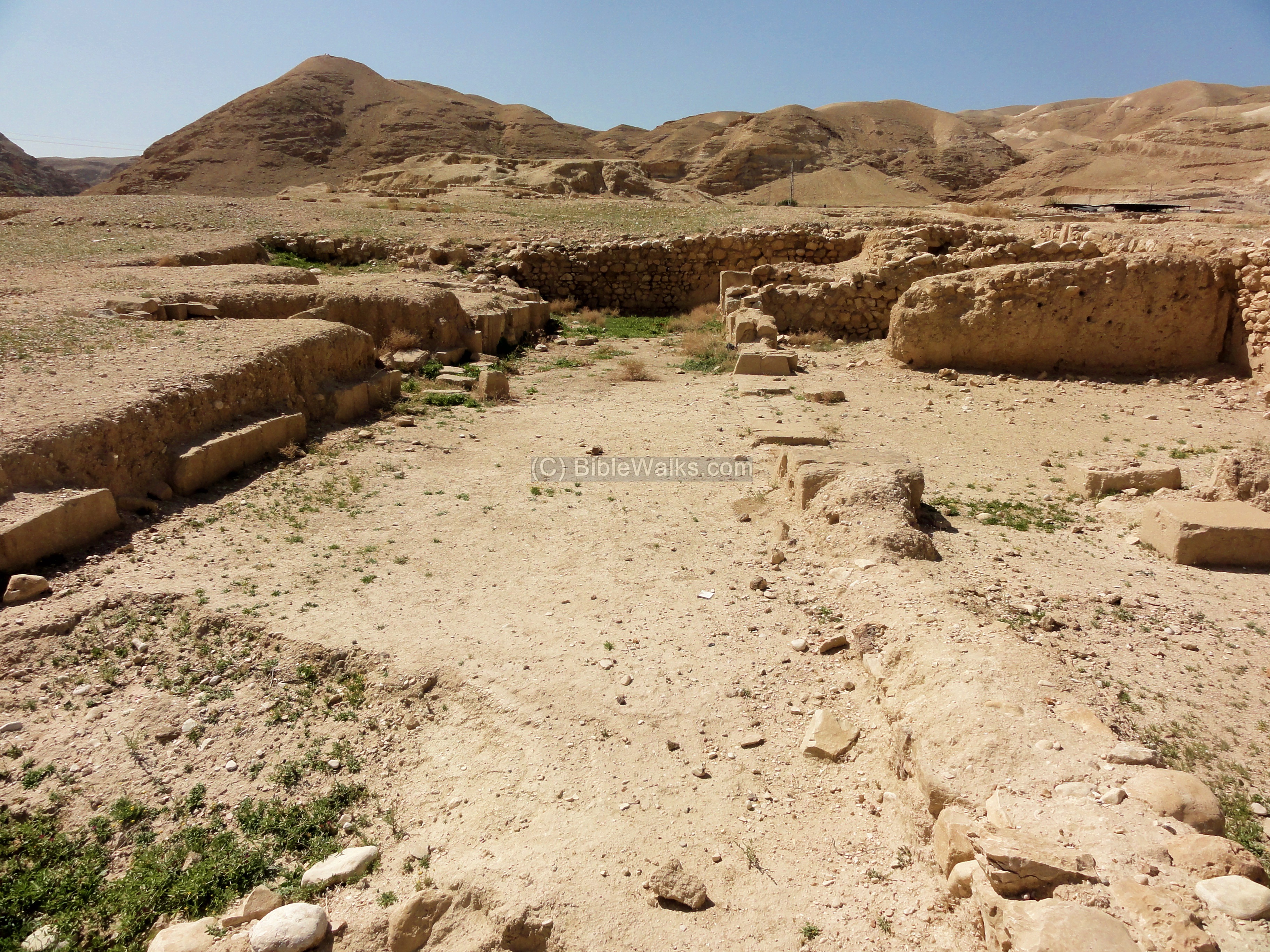
ruins of ancient synagogue, Jericho, courtesy, BibleWalks.com
The town of Jericho today is an Arab settlement of roughly 20,000 Arab settlers and their descendants. It is located in the southern Jordan Valley, about 15 miles east of Jerusalem, just west of the Jordan River and just north of the Dead Sea. It is believed to be one of the oldest inhabited cities in the world and containing the oldest known protective wall. It was thought to have the oldest stone tower in the world as well, but excavations at Tell Qaramel in Syria have discovered stone towers that are even older.
Jericho is described in the Hebrew Bible as the "city of palm trees". During the time of Joshua, the town commanded the entrance to the Land of Israel. Hence while Joshua was still encamped at Shittim, east of the Jordan, he sent two spies to investigate the state of the country in general and of Jericho in particular. The spies lodged at the house of a prostitute, Rehab, in the wall of the city, and, upon their presence being suspected, Rehab let them out through the window by means of a rope. When the armies of Joshua finally crossed the Jordan and encamped nearby at Gilgal, they besieged the city, marching around it once a day for six days and seven times on the seventh day. When the last circuit had been made and while the [seven] priests blew trumpets, the Israelites were ordered to shout, and when they did so, the walls fell down before them. The conquerors, by special command of the Lord, spared the life of none, not even the cattle. The only exception was Rehab and her family, who were saved due to the kindness she showed to the spies. The city and everything in it were then burned; only the vessels of gold, silver, copper, and iron were declared sacred and were reserved for the treasury of the Lord. Afterwards, Joshua pronounced a solemn curse on anyone who should rebuild the city.   

The site of Jericho was then allotted to the tribe of Benjamin. When the Kingdom of Israel was divided into north and south, Jericho, even though part of Benjamin tribal territory, found itself as part of the northern Kingdom of Israel in the southeastern corner near the border with the southern Kingdom of Judah. During the reign of Ahab, the city was rebuilt by Hiel the Bethelite according to the word of the lord (I Kings 16:34) which presumably lifted the curse. Afterwards, the sons of the prophets settled there. Elisha "healed" its waters by casting salt into them (II Kings 2:5, 19-22; today, this site is marked by Elisha’s Spring lying between Tel Yericho, a major archaeological site in the area, and the ancient Shalom al Yisrael Synagogue). Elijah's ascension to heaven took place nearby.
In the 1st century, the city was again destroyed, this time, by the Romans, but it was rebuilt shortly thereafter. It became a Jewish center once more under the rule of the Byzantine Empire during which time, the Shalom al Yisrael Synagogue was built. (Today, the Zionists and Arabs have restricted access to Jewish visitors.) In the 7th century, Jewish refugees from Mohammad’s Arabia, especially the Banu Nadir, settled in Jericho, augmenting the indigenous Jewish population. In addition, the literary practitioners of the Masorah mention a "Jericho Codex" existing there. The city remained a Jewish center until the coming of the Crusaders in 1099 at which point, Jericho was completely destroyed. For many centuries afterward, no Jew lived there but Jewish visitors and travelers often traversed the area.

After World War I, there was a small Jewish community in the city but they were forced to leave after the Arabs became violent. After the War of Independence in 1949, the Arabs of Jordan occupied and ruled Jericho in which state it remained for the next 19 years. In 1967, the area was liberated by Israel, but it was handed over to the newly-formed Palestinian Authority in 1994.

In 1977, Jews began returning to the area, with the founding of the village of Mitzpe Yericho during the holiday of Sukkot. It was supposed to have been located on government lands adjacent to Jericho. But due to the objection of then Defense Minister Ezer Weizman, they were moved to Mishor Adumim. Agriculture Minister Ariel Sharon suggested a few days later that they relocate to a barren hilltop overlooking the city, the current location. The original residents of the area were a mixed group of both religiously observant and non-observant Jews. In 1979, they split up into two groups, and the non-observant members established a new community, Vered Yericho, located below Mitzpe Yericho and closer to Jericho. The third community, Mevo'ot Yericho, founded in 1999, is today, an Israeli communal settlement located just north of the city, in the Yitav Valley. In more recent years, Nahal Elisha was founded on the eastern outskirts of the city.

Saturday, June 20, 2020

KIDRON VALLEY (VALLEY OF JEHOSHAPHAT)/MOUNT OF OLIVES

Jewish cemetery, Mount of Olives, overlooking Valley and the
Temple Mount, courtesy, LandOfIsraelBurials.com
In the time of Joshua, the area in and around Jerusalem, including the Valley of Jehoshaphat, was allotted to the tribe of Benjamin. In early Jewish tradition, this Valley was said to be more of a metaphor than an actual valley. According to the Prophet Joel, at the end of days, Yhwh would gather all the heathen in the Valley of Jehoshaphat (transl. god judges) and He would judge them according to their misdeeds to Israel, the Last Judgement. In Jewish tradition, the walls behind the Temple area that face this valley will be where the messiah will first appear, and from the Mount of Olives, on the opposite side overlooking the valley as well as the Temple area, the dead will be resurrected upon his coming. Jewish preference throughout the centuries to be buried on the Mount of Olives had more to do with this than with any significance regarding the valley below, already the burial site of such Biblical figures as Absalom son of David, the priest Zechariah, and the sons of Hezir, a priestly family of Jerusalem. Indeed, this valley was not referred to as the “Valley of Jehoshaphat”, but a simple land formation formed by the upper reaches of the Nahal Kidron. After the destruction of Jerusalem and the Second Temple by the Romans on the 9th of Av (Tisha B’Av), the Jews were banished from the area but still continued to celebrate the festival of Sukkot on the Mount of Olives. As the Mount was slightly higher than the Temple Mount and because it offered a panoramic view of the Temple site, it also became a traditional place for lamenting its destruction every Tisha B'Av. It wasn’t until the beginning of the 4th century that Christian pilgrims began to identify the valley below as the “Valley of Jehoshaphat” due to its location. Later on, Jews and Muslims also accepted this designation.

For centuries, especially since the Crusader period, the Arabs, usually from nearby Silwan, often prohibited Jewish burial on the Mount for a variety of reasons, and Jewish gravestones were often desecrated. By the mid-1850s, the villagers of Silwan were paid £100 annually by the Jews in an effort to prevent the desecration of graves. Among the most prominent people buried there might be mentioned: Rabbi Meir Poppers (d. 1662), a prominent rabbi and kabbalist from Bohemia (today, the Czech Rep.); Yehudah Hasid who led approximately 1000 Jews from Eastern Europe to settle in Jerusalem in 1700; Chaim ibn Atar who came from Morocco and established the Knesset Yisrael Yeshivah in 1742; Abraham Gershon of Kutow, son-in-law of the Baal Shem Tov, he was closely associated with the Kabbalist Yeshivah Bet El in Jerusalem beginning in 1747 led by Rabbi Shalom Sharabi of Yemen who was also buried on the Mount; Moshe Biderman, Lelover Rebbe who, it is said, took the cloak of Napoleon Bonaparte, brought it to Jerusalem, and from it, made a cover for the Ark of the Covenant; Rabbi Joseph Sundel Salant (d. 1866), devoted student of the Musar movement as well as one of the earliest Ashkenazi Chief Rabbis of Israel (1837-1866); Rabbi Meir Auerbach (d. 1877), co-founded, along with Rabbi Shmuel Salant, later Ashkenazi Chief Rabbi, the Vaad Clali, an umbrella organization of all kollelim in Israel; Rabbi Yehudah Alkalai, Sephardic rabbi from Serbia who was one of the forerunners of the Zionist movement and inspired the founding of Petah Tikvah in 1878; the first, and so far, only female Rebbe, known as the Maiden of Ludomir (d. 1888); Rabbi Yehoshua Leib Diskin (d. 1898) who served as rabbi in Brisk and Jerusalem; Jacob Saul Elyashar (d. 1906), Sephardi Chief Rabbi of Ottoman Palestine since 1893; the Ben Ish Chai (d. 1909), prominent Haham of Baghdad; Shimon Hakham (d. 1910), Bukharan writer and translator of Jewish holy texts and stories in Judeo-Tajik; Israel Dov Frumkin (d. 1914), Israeli journalist who helped found one of the first Hebrew newspapers in Israel, Havatzelet in 1865.

Of those who were buried on the Mount during the period of the British Mandate (1917-1948): Shlomo Moussaieff (d. 1922) one of the founders of the Bukharan Quarter in Jerusalem; Eliezer Ben-Yehuda (d. 1922) reviver of spoken Hebrew; Jacob Israël de Haan (d. 1924), journalist who came from Holland and who identified with the orthodox Agudat Yisrael party resulting in his assassinated by the Haganah; Nosson Tzvi Finkel (d. 1927) founder of the Slobodka Yeshivah in Hebron; Solomon Eliezer Alfandari (d. 1930), Chief Rabbi of Damascus (1897-1904) and Safed (1911-1918); Nissim Behar (d. 1931), educator and advocate for the Alliance Israelit Universelle education system; Boris Schatz (d. 1932), an avowed anti-secularist, founder of the Bezalel School of Arts and Crafts in Jerusalem; Yosef Chaim Sonnenfeld (d. 1932), Hareidi Chief Rabbi of Jerusalem (not to be confused with the position of Ashkenazi Chief Rabbi); Yossele Rosenblatt (d. 1933), prominent Hazzan; Abraham Isaac Kook (d. 1935) who held the office of Ashkenazi Chief Rabbi in 1921, after the position was vacant for a few years; Yaacov Meir (d. 1939), formerly Chief Rabbi of Palestine (1906-07) until he was overthrown by his political enemies, after serving in Salonica, he became Sephardic Chief Rabbi of British Mandate Palestine since 1921; Henrietta Szold (d. 1945), founder of Hadassah; Meir Feinstein (d. 1947) and Moshe Barazani (d. 1947), celebrated freedom fighters against British imperialism; Harry Fischel (d. 1948), American businessman and philanthropist, one of the last individuals to be buried on the Mount before the Arab occupation in 1948.

During the War of Independence in 1948, the entire area fell to the Arab occupying forces of Jordan. All Jews who lived in the area were ethnically cleansed and Jewish visits were prohibited. Officially approved massive vandalism of gravesites took place and 40,000 of the 50,000 graves were desecrated. King Hussein permitted the tombstones to be used as building materials for roads and latrines as well as partially for the construction of the Intercontinental Hotel at the summit of the Mount of Olives together with a road that cut through the cemetery. Such activity had the stamp of approval of the United Nations, Europe, and most Zionists who enthusiastically looked the other way. This was the situation until 1967, when Israel liberated the Old City and surrounding region in the Six Day War. After the War, restoration work of the cemetery began, under international condemnation. It was later re-opened for burials.

The following is a partial list of the prominent personalities that are buried on the Mount of Olives since 1967: Princess Alice of Battenberg (d. 1969) mother of Prince Philip Duke of Edinburgh and recognized as Righteous Among the Nations for saving Jews in Greece; Shmuel Yosef Agnon (d. 1970), writer and Nobel Prize laureate; Ashkenazi Chief Rabbi Isser Yehuda Unterman (d. 1976); writer Uri Zvi Grinberg (d. 1981)Zvi Yehuda Kook (d. 1982) Rosh Yeshivah of the Mercav Harav Yeshivah and son of Abraham Isaac Kook; Robert Maxwell (d. 1991) British MP and (dishonest) philanthropist; Prime Minister Menachem Begin (d. 1992) who cruelly ethnically cleansed the Sinai of Jews; Ashkenazi Chief Rabbi Shlomo Goren (d. 1994); Revisionist freedom fighter Israel Eldad (d. 1996); British Chief Rabbi Immanuel Jakobovits (d. 1999); Gavriel and Rivka Holtzberg (d. 2008) Chabad emissaries to Mumbai India killed by Pakistani terrorists; Moshe Hirsch (d. 2010) leader of Neturei Karta; Meyer Rosenbaum, Chief Rabbi of Cuba.

ER RIADH, TUNISIA


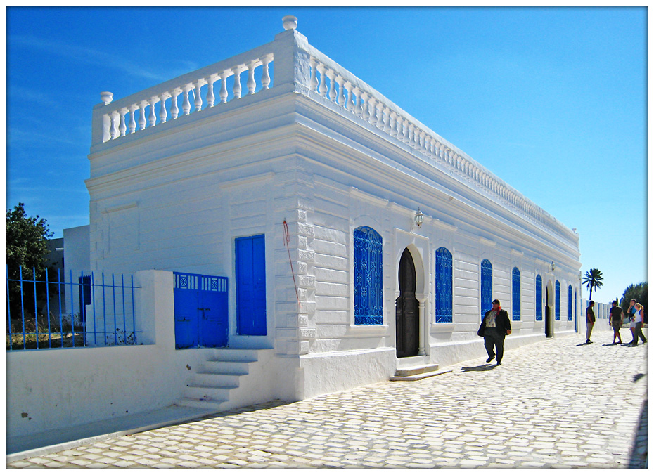
street corner in Djerbahood, er Riadh, Tunisia, with
sample artwork in background, artwork courtesy
Mario Belem, picture courtesy, MistakerMaker.org
The Arab-occupied town of er Riadh is located almost in the center of the island of Djerba off the southern coast of the Arab-occupied country of Tunisia. It was originally called Djirt, then later nicknamed as Hara Seghira or “Small Neighborhood”. Probably the first thing that one notices upon entering the town is the pervasiveness of its international street art. This is especially so in the neighborhood of Djerbahood, an indigenous Amazigh (Berber) neighborhood in the northern part of this otherwise "Arab" town. 
Beginning in the 3rd century BCE, er Riadh/Djirt was part of the Berber Kingdom of Numidia. Roman rule followed in 46 BCE. In the 8th century, the town, as well as the rest of North Africa, became occupied and colonized by the Arabs and governed by their various dynasties. Since the latter 10th century and the rule of the Arab Fatimids, the town was governed by various other dynasties, some indigenous Berber, some not – the Masmuda Berber Almohads whose rule was briefly interrupted by the Almoravid Sanhaja Berber Banu Ghaniyas; the Kurdish Ayyubids; the Hintata Berber Hafsids; the Turkish Ottomans; the French; and finally, the Arabs again.
It was an anomaly in North Africa, and in the “Arab world” in general, that at one time, er Riadh/Djirt had become a mostly Jewish town. According to tradition, the first Jews settled in Djirt, among the indigenous Berbers, as refugees from the Babylonian destruction of Solomon’s Temple and the conquest of Judea in 586 BCE. (A second wave of Jewish immigration occurred after the Romans destroyed the Second Temple in 70.) Jews and Berbers have lived together in peace ever since. It was said that the el Ghriba synagogue which was built, contained a door and a stone from the destroyed Temple that was brought over by some of the high priests. Another tradition says the synagogue was built on a spot where a young girl (ghriba, "the isolated one") who had not been accepted by the others, had lived. After her death, her uncorrupted body was found by the Jews of the nearby village, and then buried in a cave which became the site of an annual pilgrimage for Lag BaOmer. Today, the synagogue is located on the southern border of the town. Centuries later, it and the surrounding area became the scene of Arab terrorist attacks. In 1985, during the festivities for Simchat Torah, a local policeman responsible for the synagogue‘s safety opened fire into the crowd of celebrating Jews, killing three people, including a child, and wounding 15. On April 11, 2002, a truck full of explosives was detonated close to the synagogue, killing 21 – 14 German and 2 French tourists, and five locals. Al-Qaeda claimed responsibility for the bombing, which was found to have been masterminded by Khalid Sheikh Mohammed and financed by a Pakistani resident of Spain.
Er Riadh today is surrounded by towns of mixed Berber, Arab settler, and sub-Saharan African residents – Medjine, the closest; Megmag; el May, a mostly Berber village; Oualegh; Barkouk; and Houmt Souk, the major city on Djerba lying a few miles to the north on the coast. Inside the town itself and in Djerbahood, is the Guest House, an authentic Berber house from where travelers can explore other parts of the island as well as southern Tunisia on the mainland.
Die Geschichte der Synagoge....
el Ghriba Synagogue, er Riadh, Tunisia, courtesy, fotocommunity.de

Sunday, June 14, 2020

JABBOK RIVER

Landscape of Jordan.JPG
Jabbok River Valley, courtesy, Wikipedia
The Jabbok River is one of the principal tributaries of the Jordan, flowing from that river’s east bank in the Arab-occupied Kingdom of Jordan about midway between the Sea of Galilee in the north and the Dead Sea in the south. In the course of its 65 mile length, it passes south of the cities of Gilead (Ajlun), Gerasa (Jerash), and Mafraq, finally ending in the northern deserts of the East Bank near the border with Arab-occupied Syria. According to the Book of Genesis, in the hamlet of Penuel in the Jabbok River Valley, Jacob struggled with the angel after his escape from his father-in-law in Syria, and later, it is mentioned in connection with the meeting between Jacob and Esau. The Jabbok was also the scene of an important battle between the Israelites and the Amorites. According to Numbers 21:22-24, Sihon, King of the Amorites, refused to allow the tribes of Israel to pass through his land on their way to Canaan and instead, sent an army against them. “And Israel smote him with the edge of the sword, and possessed his land from Arnon unto Jabbok…” After the Israelites settled in the Promised Land, the Jabbok served as the border between the tribes of Gad and Reuben and the Kingdom of Ammon, today, the land in and around Amman. Some time during or after the Babylonian Captivity, the Jewish family of Tobiah ruled Ammon and that dynasty continued to rule this area until the time of the Maccabbees.

Over the centuries, Arab settlers migrated to the river valley from the Arabian Peninsula, especially after the Crusader period. However, Jewish travelers, merchants, and explorers still traversed the area. Ashturi haParhi in the 14th century and Yehoseph Schwarz in the 19th would make in-person researches on locations of Biblical sites and have identified the Jabbok River with, what the settlers called, the “Zarqa”. Scholars tend to disagree as to why the river received this name. Schwarz states that the Arabs named it the Zarqa because it touched the fortress of Zarqa which was on the route between Damascus and Mecca. But nowadays, the general opinion is that the Jabbok was given this Arabic name on account of the bluish color of its water (“Zarqa” is the Arabic word meaning “blue”).

Today, Jews are prohibited from residing in any part of the river valley as they are in the rest of the Kingdom of Jordan.

Thursday, June 11, 2020

SAMARIA

Samarian Mountains 259x100 Top Sites to Visit in Samaria
the region of Samaria, courtesy, Shalom Israel Tours
Samaria (the Shomron) is both an ancient town and region in the northern half of Israel. Considered Israel’s heartland, it is traversed in the center from north to south by a mountain ridge running as far south as Judea. It was an area rich in Biblical Jewish history. During the time of Joshua, it formed the bulk of the western half of the tribal territory of Menasheh. (The eastern half lie east of the Jordan River.) For over 400 years, Shiloh served as capital of the Israelites and it was here where the Tabernacle had rested during that time. When the Kingdom of Israel split in two, the region of Samaria became a major component of the northern Kingdom of Israel. As Jerusalem remained the capital of the southern Kingdom of Judah, the capitals of the northern kingdom were invariably Shechem (Nablus), Penuel, Tirzah, and finally the city of Samaria. This city was built by King Omri, in the seventh year of his reign, on a mountaintop. He had bought this mountain for two talents of silver from a vintner named Shemer, after whom the mountain and later the city, and then the surrounding region, was named (I Kings 16:24). In 722 BCE, the inhabitants were driven into exile by the Assyrian Empire and the land was then resettled by other peoples who would come to adopt the religion of Israel. These would become the Samaritans, after the region in which they now lived. (This Old Testament assertion has been hotly contested. Recent DNA studies of the Samaritans show that they are the remnant descendants of the tribes of Menasheh and Ephraim.) After the return from the Babylonian Captivity, the returning Judeans (Jews) rejected the Samaritans and the two groups remained hostile to each other ever since, until a ruling by the rabbis in Jerusalem in 1842 which recognized the Samaritans as belonging to the House of Israel.   

Under Herod, the city of Samaria became the capital of the district of Samaria, the city itself being known as Sebaste, the Greek equivalent of the Latin "Augusta", so named in honor of Augustus Cæsar. Josephus speaks of the soldiers of Sebaste who served in the army of the House of Herod and who later sided with the Romans resulting in the city being attacked by Jews at the outbreak of the war against Rome. Sebaste is also mentioned in the Mishnah where its orchards are praised. Jerome, an early Christian and church father, records the tradition that the city was the burial-place of the prophets Elisha and Obadiah, as well as of John the Baptist. However, during the Crusader occupation, the 12th century Jewish traveler from Spain, Benjamin of Tudela, does not relate to these tombs at all but states only that traces of the palace of King Ahab of Israel were still visible, and that in his day, he found no Jewish community in the city. Beginning in 1931, a major international archaeological expedition there involved Professor Eliezer Sukenik of the Hebrew University who worked conjointly with John Winter Crowfoot of the British School of Archaeology in Jerusalem and Kathleen Kenyon of the Palestine Exploration Fund.

Since the Crusader occupation, the region of Samaria played a significant part in the history of the Jews in Israel. Shechem was home to an ancient Jewish community as well as a Samaritan community. The Jewish community waxed and waned over the centuries depending on the security situation. The same with the town of Anin near Umm el Fahm. In the 18th and 19th centuries, the Turkish authorities settled Arab migrants from Yemen in Anin which eventually drove the Jews away.

In 1831, the Arab settlers of the region in and around the fortress of Sanur had rebelled against the rule of Abdalla Pasha. A renowned band of Jewish warriors from the Lebanon were called to subdue the rebellion which they did successfully, and the Pasha ordered the fortress and town levelled to the ground, in which state they remained for many years afterward. Later, an Arab settlement was built on the site. By the late 70s, a Jewish community was established adjacent to the Arab settlement.

In c. 1904, the last Jews left Shechem, fleeing from the high taxes that were imposed only on Jews. The Samaritan presence remained constant (see Mount Gerizim). In nearby Awarta, a Jewish community had long ago sprung up but was expelled by the Arabs in 1912. By the beginning of the British Mandatory period, the city of Tulkarm had a small Jewish population in the midst of a majority Arab population. In 1925, an agricultural school was established there by a Jewish businessman from China, Sir Ellis Kadoorie, specifically to teach the local Arabs modern methods in farming. The later Arab riots throughout the country ethnically cleansed Tulkarm of its Jews.

During the War of Independence in 1948, Samaria came under Arab occupation, remaining so until liberated by Israel in 1967. The Samaritans were left alone but, since the Israeli army and government were led by Zionists, Jews were banned from returning to the area. After several attempts to reestablish a Jewish community in the town of Samaria, a compromise was reached and the Jews were given land at the army base at nearby Kadum. A community was established and the town of Kedumim came into being – the first Jewish town in the Samaria region since Biblical times. Kedumim was soon followed by other towns throughout Samaria: Elkana, Reihan, Sal’it, Shavei Shomron, Ariel (which grew into a city of some 20,000 and was designated the capital of Samaria), Karnei Shomron, Sanur, Kfar Tapuah, Mevo Dotan, Elon Moreh (where Abraham first rested upon entering the Promised Land), and many others. During the so-called “Second Intifada”, the entire Samaritan community in Shechem was forced by the Arabs to move out. They settled in the nearby village of Kiryat Luza, built for them by the Israeli government. Today, the closest to Shechem the Arabs and Zionists will allow a Jew or Samaritan, are in the Jewish community of Har Bracha and the Samaritan community of Kiryat Luza. Both lie on top of Mount Gerizim just outside, and overlooking, the city. Meanwhile, the community of Sanur, along with 3 others including Homesh, was violently ethnically cleansed in 2005 by the Zionists led by Ariel Sharon. Soon after, Homesh became a flashpoint in the effort to rebuild these illegally destroyed communities.

The many Jewish holy sites in Samaria had been places of Jewish pilgrimages for thousands of years (access now severely restricted by the Zionists): the Tomb of Joseph in Shechem; the Tombs of Eleazar and Ittamar in Awarta; the Tombs of Joshua and his father Nun and the Tomb of Caleb in Kifl Hares; the Tomb of the High Priest Eli in Shiloh. The Samaria National Park was created by the Israeli government (!) and is today under authority of the Israel Nature and Parks Authority. It is considered to be the largest national park in Israel today.

In 2014, the first “Bible Marathon” took place in Samaria, stretching the mandated 26 miles, from Rosh Haayin to Shiloh. It follows the path taken in Biblical times when a messenger went from the site of Israel’s defeat at the hands of the Philistines (today Rosh Haayin) to the High Priest Eli in Shiloh. It was the first recorded marathon in history, predating the Greek.

Sunday, June 7, 2020

HULEH VALLEY

The Huleh Valley, Israel, courtesy, Wikipedia
The Huleh Valley used to be a lake prior to its draining. It lies about 15 miles north of the Sea of Galilee and is about 7 feet above sea level. Today, it is an agricultural region in northern Israel with abundant fresh water. It is also a major stopover for birds migrating along the Syrian-African Rift Valley between AfricaEurope, and Asia.

"The waters of Merom", as it is called in the Book of Joshua, is given as the name of the place at which the hosts of the peoples of northern Canaan assembled to meet Joshua and the Israelite warriors. The commander-in-chief of the Canaanite forces was Jabin, King of Hazor. The only hint as to Joshua's method of attack is the statement that “he came against the enemy suddenly, and fell upon them”. This probably indicates a night march and early morning attack. The Israelites “smote them, put them to flight, and pursued them in every direction. Their horses were hamstrung, and their chariots were burned, while their cities and the whole country were laid waste”. After these battles and the ensuing Israelite victories, the area in and around Lake Huleh became allotted to the tribe of Naphtali. In the 8th century BCE, the lake was captured by the Neo-Assyrian Empire's armies under Tiglath-Pileser III (reigned 745–727 BC) and its inhabitants were driven away. After the Babylonian Captivity (538 BCE) and later in the Hellenistic and Hasmonean periods, when the Jews resettled in the area, the growing of rice became a major agricultural industry.
Over the centuries, however, Lake Huleh became marshland and also a breeding ground for mosquitoes carrying malaria. It wasn’t until the 1830s that Arab migrants, mainly refugees, established permanent settlements in the area that were conducive to the swamp environment. The first modern Jewish settlement in the Huleh Valley, Yesud HaMa'ala on the western shore of the lake, was established in 1883 during the First Aliyah. Since then, plans, and several attempts, were made, either by Jews or the Turks or the British, to drain the nearby swamps and turn the area over to agriculture. In 1934, during the British Mandate, the Palestine Land Development Company was awarded this concession by the Mandatory government and drew up plans to drain and irrigate the valley which brought scientific expeditions to the area. This activity was forced to be suspended at the outbreak of the Arab riots and World War II after that. It wasn’t resumed until after Israeli independence.
In 1951, the draining of the swamps began, lasting seven years and carried out by the Jewish National Fund and aided by the Construction Aggregate Company of Chicago. During this time, the Israeli government invited John Zuckerman, an agriculturalist from California, to visit Israel as advisor on a project. The Syrian Arabs, for their part, often interfered with the execution of the project by repeatedly opening fire on work crews along the Jordan course and by obtaining from the UN a stipulation that the dredged earth and stone be deposited on the western river bank only (although the eastern bank was Israeli territory as well). But in spite of the usual problems with the surrounding Arabs, the draining was successful, achieved by two main engineering operations: the deepening and widening of the Jordan River downstream; and two newly-dug peripheral canals diverting the Jordan at the north of the valley. Though perceived at the time as a great national achievement for Israel, with the advent of the modern environmental movement, it became evident that the transformation of the swamp into agricultural land involved significant trade-offs and had effects on the ecosystem that had not been perceived previously such as the extinction of the unique endemic fauna of the lake. In fact, this concern was the impetus for the creation of the Society for the Protection of Nature in Israel in 1953. Due to the activities of this Society, in 1963, a small area of recreated papyrus swampland in the southwest of the valley was set aside and thus, it became the country's first nature reserve, the Huleh Nature Reserve. The next year, it was officially inaugurated and today, it is listed by the Ramsar Convention on Wetlands, as a Wetland of International Importance. In the early 1990s part of the valley was flooded again in the wake of heavy rains. Therefore, it was decided to develop the surrounding area and leave the flooded area intact. The new site, the Agmon HaHula, has become the second home for thousands of migrating birds in the autumn and spring. In November 2011 the Huleh painted frog, classified as extinct since 1996 by the IUCN as a result of the marsh drainage, reappeared to park patrollers. The reappearance was confirmed by the Israel Nature and Parks Authority.
Today, several communities have been established in the area since the establishment of Yesud Hamaala – Hulata (1937), Ramot Naphtali (1945, located adjacent to the Nebi Yesha Forest), Yiftah (1948), Sde Eliezer (1950), and Gonen (1951).