For the record, I'm neither an academic nor a scholar, and admittedly, I've never been to many of the places posted here. So if someone should find a mistake, or believe I omitted something, please feel free to email me and I'll correct it.

I can be contacted at dms2_@hotmail.com.

Sunday, March 21, 2021

REHOVOT

Rehovot, Israel
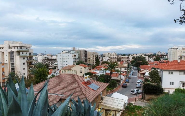
view of Rehovot, courtesy, JoysOfTraveling.com
Rehovot is a city in the Central District of Israel, about 12 miles south of Jaffa. In 2019 it had a population of 143,904.

During the time of Joshua, the site of Rehovot was allotted to the tribe of Dan. According to some archaeologists and historians, and subject to debate, this place was referred to as Keren Doron as mentioned in the Jerusalem Talmud (Peah 7:4) and it had remained inhabited by Jews and possibly Samaritans up until the Roman and Byzantine periods. (Later Arab settlers referred to it as “Khirbet Deiran”.) By the beginning of the Zionist era in the early 1880s, this region was an uncultivated wasteland with no trees, houses or water. In 1890, the modern city of Rehovot was established by BILU pioneers of the First Aliyah from Poland and headed by Rabbi Samuel Mohilever. It was on the coastal plain near Khirbat Deiran on land purchased from a Christian Arab from Jaffa on behalf of the Menuchah v’Nahalah Society of Warsaw. Israel Belkind, the founder of the BILU movement, proposed the name "Rehovot" based on Genesis 26:22: "And he called the name of it Rehovot; and he said: 'For now the Lord hath “made room” (hiRHiV) for us, and we shall be fruitful in the land'." This Bible verse is also inscribed in the city's logo. However, archaeologists have located the Rehovot referred to, as in the Negev Desert south of Beersheba.

Since the other Jewish communities were financially supported by the Baron Edmond de Rothschild, Rehovot was the first one established independent of his support. At first the Turkish government hindered the development of this community by placing obstacles in its way; but in 1894, the friction between the authorities and the pioneers having somewhat abated, Rehovot began to thrive. The Jewish Colonization Association granted the community a loan of 125,000 francs ($25,000) and houses were built along two parallel streets: Yaakov and Binyamin Streets. A fine vineyard was then laid out by Jewish day-laborers, containing 250,000 vines and there were also a great number of almond, mulberry, and other trees as well as cereals but the inhabitants had to grapple with agricultural failures, plant diseases, and marketing problems. The town’s synagogue was established in 1903. The first citrus grove was planted by Zalman Minkov in 1904. Today, the Minkov Orchard Museum was built on the site by his descendants who now live in Switzerland. In 1908, the Workman's Union (Hapoel Hazair) organized a group of 300 Yemenite immigrants then living in the region of Jerusalem and Jaffa, bringing them to work as farmers in the town resulting in a few dozen families settling there. They built houses for themselves in a plot given to them at the south end of the town, which became known as Sha'araim. In 1910, Shmuel Warshawsky, with the secret support of the Jewish National Fund, was sent to Yemen to recruit more agricultural laborers. Hundreds arrived beginning the next year and were eventually housed in a large extension of the Sha'araim quarter.

In 1920, the Rehovot Railway Station was opened, which greatly boosted the local citrus fruit industry. A few packing houses were built near the station so as to enable the fruit to be sent by railway to the rest of the country and to the port of Jaffa for export to Europe. By 1931, Rehovot became connected to Palestine’s electricity grid, then owned by engineer Pinhas Rutenberg. That same year, the first workers’ moshavKfar Marmorek, was built on lands acquired by the Jewish National Fund in 1926 from the neighboring Arab village Zarnuqa, in which ten Yemenite Jewish families, evicted from Kinneret, were resettled to work the land. They were later joined by thirty-five other families from Sha'araim. Today, it is a suburb of Rehovot. The agricultural research station that opened in 1932 became the Department of Agriculture of the Hebrew University of Jerusalem. In 1934, Chaim Weizmann established the Sieff Institute, which later became the Weizmann Institute of Science. In 1937, Weizmann built his home on the land purchased adjacent to the Sieff Institute. The house later served as the presidential residence after Weizmann became president in 1948. He and his wife are buried on its grounds.

Under the UN Partition Plan in 1947 which began the War of Independence, Rehovot was included in the proposed Jewish state. During the war, on February 29, 1948, the Lehi blew up the Cairo to Haifa train shortly after it left Rehovot, killing 29 British soldiers and injuring 35. Lehi said the bombing was in retaliation for the Ben Yehuda Street bombing in Jerusalem a week earlier, led by Arabs but assisted by some British soldiers. On March 28, Arabs attacked a Jewish convoy near Rehovot. After the war, the town expanded and in 1950, Rehovot, which had a population of about 18,000, was declared a city. The Kaplan Medical Center was founded three years later and at present, acts as an ancillary teaching hospital for the Hebrew University Medical School.

The city has had three football clubs representing it in the top division of Israeli football: Maccabi Rehovot (est. 1912) between 1949 and 1956, Maccabi Sha'arayim (est. 1950) between 1963 and 1969 and again in 1985, and Hapoel Marmorek (est. 1949) in the 1972–73 season.

Rehovot is also home to numerous industrial plants, and has an industrial park in the western part of the city. This park includes the Tnuva dairy plant, the Yafora-Tavori beverage factory, and the Feldman ice cream factory. The Tamar Science Park, established in 2000, is a high-tech park of 1,000 dunams at the northern entrance of the city and adjoins the older Kiryat Weizmann industrial park. The Weisgal Center Water Park is located in the south of the city. The Peres Academic Center College was established in 2006.

Today, there are three significant Jewish ethnic minorities in Rehovot: Russian Jews, Yemenite Jews, and Ethiopian Jews, concentrated largely in the Kiryat Moshe and Oshiot areas. In addition, there is a growing religious community from English-speaking countries who primarily live in Northern Rehovot around the Weizmann Institute.

Sunday, March 14, 2021

THE RED SEA


courtesy Pinterest
The Red Sea is a seawater inlet of the Indian Ocean, connected to it by the Bab el Mandeb strait in the south between Yemen and Arab-occupied Djibouti. It is the world's northernmost tropical sea, and has been designated a Global 200 ecoregion. Lying between Africa and Asia, it is underlain by the Red Sea Rift, part of the Great Rift Valley which stretches from Arab-occupied Lebanon to Mozambique. In the north, the Sinai Peninsula juts out, forming the sea into the shape of a fork with the Gulf of Aqaba/Gult of Eilat forming one tong, and the Gulf of Suez, leading to the Suez Canal, forming the other. From east to west, the Red Sea is long and narrow. On the eastern coast lies the ancestral Arab nations of Yemen and Saudi Arabia, the ancient land of Edom, now part of the Arab-occupied country of Jordan, and the southernmost Israeli port of Eilat. Along the western coast lies Egypt proper, Nubia (Sudan), Djibouti, and the African nation of Eritrea.

Centuries before it was made famous in the story of the Exodus, the Red Sea was a conduit of trade between Egypt, especially under Queen Hatshepsut, and Africa, most notably, the ancient Lands of Punt (Somalia), Nubia (Sudan), and India.

According to Jewish tradition, the Israelites, escaping from slavery in Egypt, encamped at the western shoreline of the Red Sea. Then god parted its waters and the Israelites went through. Pharaoh’s armies pursued them through the sea but the waters closed in on them drowning them all. Now the question remains, where, along the seashore, did this event take place? This was a matter of debate among scholars and historians. Some place the crossing of the Red Sea in the vicinity of Suez and point out the high tides of the sea (up to 6½ ft.). In fact, Rabbi Saadia Gaon (882‒942), in his Judeo-Arabic translation of the Pentateuch, identifies the crossing place of the Red Sea as Baḥar al-Qulzum, meaning the Gulf of Suez. Others maintain that the Red Sea was crossed at the Great Bitter Lake, but an east wind could lower the water level by only a few inches at the most. This theory, furthermore, is unable to account for the places Pi-Hahiroth, Migdol, and Baal-Zephon which the Israelites passed. Still others point to the site of Nueibeh on the eastern Sinai coast pointing out the sea bed would be conducive to a crossing if a strong wind blew. The majority opinion today however, identifies the Red Sea of the Exodus, referred to as “Yam Soof”, “Reed Sea”, in the Bible, with one of the lagoons on the shores of the Mediterranean. As such, some locate it at Baḥr Manzala, or the Sirbonic Lake, and identify Pi-Hahiroth with Tell al-Khayr, Migdol with Pelusium, and Baal-Zephon with the sanctuary of Zeus Cassius on the isthmus dividing the lake from the sea, the former being occasionally inundated by waves from the latter when an east wind is blowing. While it is true that no reeds now grow on the salty coast of the gulf, different conditions may have prevailed along the northern end in ancient times, where fresh-water streams discharged into it.

King David had acquired access to the Sea through his wars with the Edomites, and the commercial ships sent by King Solomon from the southern port of Eilat (see Eilat), often traversed the area during his trading expeditions with the ports of Africa and India. After Solomon’s death, Eilat was briefly lost to the Edomites but was soon regained by the Kingdom of Judah under Jehoshaphat and Uzziah. Soon, the Gulf of Elath became a vital outlet to the south for the kings of Israel and Judah and their Phoenician allies. Later the Nabateans used it for their maritime trade and overland transport to Petra and Gaza.

In Egypt, the Gulf of Clysma (Suez) was used as the shortest route to the Mediterranean. The Sea was connected via the Bitter Lakes with the Nile and the Mediterranean by a canal which already existed in the days of Pharaoh Necoh and which was repaired by the Persian Emperor Darius I, the Egyptian Greek Ptolemies, and the Romans. In addition, the town of Al Quseir, on the coast midway between Suez and Nubia, had been an important port, serving as a thriving center of trade. In the Hellenistic period the discovery of the monsoon wind systems revived direct trade with India via the Red Sea. A Greek historian recorded a fleet of 120 ships exporting pottery, slaves, wine and precious materials. The important town of Safaga, which lies to the north of Al Quseir on the coast, was founded between 282 BCE and 268 BCE, by Satyrus and was called Philotera in honor of the deceased sister of the Pharaoh Ptolemy II Philadelphus. Suakin, in Nubian territory, was likely Ptolemy's Port of Good Hope, Limen Evangelis. Under the later Ptolemies and Romans, though, the Red Sea's major port was Berenice to the north. The Red Sea was favored and expanded for Roman trade with India starting with the reign of Augustus, when the Roman Empire gained control over the Mediterranean, Egypt, and the northern Red Sea. Contact between Rome and China depended on the Red Sea, but the route was broken by the Ethiopian Aksumite Empire around the 3rd century CE. From the beginning of the 5th century, the Red Sea was the only trade route to the East open to the Byzantine Empire, which explains the tenacity with which the Byzantines fought for its control against the Jewish kings of Ḥimyar (today, Yemen). From the seventh century onward the Arabs dominated the Red Sea. The growth of the Muslim caliphate then shifted trade first to the Hijaz in Arabia and then the Persian Gulf.

By the 10th century, Suakin was a small settlement of the African Christian Beja tribe, but it began to expand after the abandonment of the port of Badi to its south. The Crusades and Mongol invasions drove more trade into the region. In 1183, Raynald of Châtillon launched a raid down the Red Sea to attack the Muslim pilgrim convoys to Mecca. The possibility that Raynald's fleet might sack the holy cities of Mecca and Medina caused fury throughout the Muslim world. However, it appears that Reynald's actual targets were the lightly armed Muslim pilgrim convoys rather the well guarded cities of Mecca and Medina. The belief in the Muslim world that Reynald was seeking to sack the holy cities was due to the proximity of those cities to the areas that Raynald raided. As early as the 14th century, there are a number of references to Venetian merchants residing at the ports of Suakin and Massawa.

Despite Suakin’s formal submission to the Muslim Mamluk dynasty in Egypt in 1317, it is believed that the city remained a center of Christianity. Arab Muslim immigrants such as the Banu Kanz gradually took over and intermarried with many of the Beja - so much so that in 1332, the Berber Muslim traveler ibn Battuta recorded there was a Muslim "sultan" of Suakin, al-Sharif Zaid ibn-Abi Numayy ibn-'Ajlan, who was the son of a Meccan sharif. Following the region's inheritance laws, he had inherited the local leadership from his Bejan maternal uncles. In the fifteenth century, Suakin was briefly part of the Adal Sultanate of the northern Land of Punt. The discovery of the sea route around Africa to India and Turkish domination put an end to international trade on the Red Sea. In 1513, trying to secure that channel to Portugal, Afonso de Albuquerque laid siege to Aden but was forced to retreat. The Portuguese cruised the Red Sea inside the Bab el-Mandeb, as the first fleet from Europe in modern times to have sailed these waters. International trade via the Red Sea was revived with the inauguration of the Suez Canal in 1869. In 1905, Arab settlers established two new towns on the western coast of the Sea – Hurghada, about midway on the Egyptian coast north of Safaga, and Port Sudan, about midway on the Nubian coast.

After the Second World War, the Red Sea experienced a traffic boom in oil tanker traffic, especially via the Suez Canal. The Canal became an important waterway to the international community. However, the Six-Day War between Israel and its Arab-occupied neighbors, culminated in its closure from 1967 to 1975. Today, in spite of patrols by the major maritime fleets in the waters of the Red Sea, the Suez Canal has never recovered its supremacy over the Cape route of southern Africa, which is believed to be less vulnerable to piracy.

Today, the Red Sea contains many offshore reefs including several true atolls. The special biodiversity of the area is recognized by the Arab government of Egypt who set up the Ras Mohammed National Park in 1983. The rules and regulations governing this area protect local marine life resulting in it becoming a major draw for diving enthusiasts. Other Egyptian diving sites include the SS Thistlegorm (shipwreck), Elphinstone ReefThe BrothersDaedalus ReefSt.John's Reef, and Rocky Island. Influenced by the culture of ancient Egypt, the architecture of the Sheraton Hotel in the resort town of Soma Bay on the southern outskirts of Hurghada, was inspired by the ancient Temple of Karnak in Luxor. Marsa Alam also has some inland attractions, such as the Emerald Mines and the Temple of Seti I at Khanais. The descendants of the ancient Egyptians, the Copts, maintain several churches and monasteries in the Eastern Desert. El Gouna, about 12 miles north of Hurghada, is an Egyptian tourist resort, owned by Samih Sawiris, a Copt, and developed by Orascom Hotels and Development, since 1989. It is part of the Red Sea Riviera, and a host city of the El Gouna Film Festival as well as the Church of St. Mary and the Archangels Coptic Orthodox church.

Major resort areas in the Sinai include Sharm-el-SheikhDahab, and Taba. Sharm el-Sheikh was closed to all swimming in December 2010 due to several serious shark attacks, including a fatality. Sharm el Sheikh is home to a Coptic church and there are other Coptic churches in the nearby towns of Ras Sedr and El Tor. The town of Taba is a major crossing point into Israel and the popular resort city of Eilat. On Eilat’s eastern border is another popular resort city, Aqaba, located in Jordan. These two places form the other Red Sea Riviera.

Popular diving sites and resort areas in Nubia include SanganebAbingtonAngarosh and Shaab Rumi.

Moulhoule is the Red Sea port in indigenous Afar territory in Djibouti which faces the Arabian Peninsula. It is separated from Yemen only by the Bab el Mandeb.

A number of volcanic islands had risen from the center of the Red Sea in recent years. Most are dormant. However, in 2007, Jabal al-Tair island in the Bab el Mandeb strait erupted violently. Two new islands were formed in 2011 and 2013 in the Zubair Archipelago, a small chain of islands owned by Yemen. The first island, Sholan, emerged in an eruption in December 2011, and the second island, Jadid, emerged in September 2013.

On the eastern side, there are several major towns that, truly are, located in ancestral Arab territory. These include al Hodeida in Yemen, and Jeddah, Yanbu, and Maqna in Saudi Arabia. 

Sunday, February 21, 2021

RAMLA

One
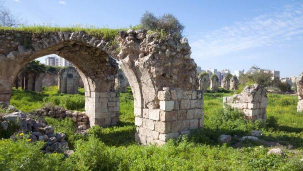
ancient ruins at Ramla, courtesy, pokku/Shutterstock posted in
TotallyJewishTravel website
Ramla is a major city in Israel located approximately 12 miles southwest of Jaffa in the Central District, along the Tel Aviv-Jerusalem Highway.  

During the time of Joshua, the site of Ramla was allotted to the tribe of Dan but the town itself was founded over two millennia later, in c. 715–717 CE by the Arab Umayyad governor and future caliph Sulayman ibn Abd al-Malik. It became the only town in Israel founded by Arab Muslims. Although originally established for Arab Muslims, it had from the beginning a large population of Christians, Jews, and Samaritans. The increase of the Samaritan farming population on the outskirts of the town was due to the efforts of Hārūn al-Rashīd, the Abbasid Caliph in the late eighth century. Since the 10th century, Ramla often served as a place of refuge for the ruling geonim from Jerusalem, accompanied by his rabbinical assembly, at times when intense conflicts would erupt between the rabbinic authorities. At that time, a Karaite and a Rabbanite community, the latter divided into Palestinians and Babylonians, existed in the town; there were also synagogues for the Jerusalemites and the Damascenes. Ramla also became a major transit hub for caravans of Radhanites – Jewish merchants who travelled in convoy from France to China and back again. In the 11th century however, the flourishing communities of Ramla suffered from a series of blows: a disastrous Bedouin raid in 1025 and two devastating earthquakes in 1033 and 1067 (in the latter, 25,000 people reportedly perished). During the Crusader occupation, beginning in 1099, the Jewish and Samaritan communities were dispersed. However, some did return and when Rabbi Benjamin of Tudela visited the area in 1170–71, he recorded “…there are remains of the walls from the days of our ancestors, for thus it was found written upon the stones. About 300 Jews dwell there. It was formerly a very great city; at a distance of two miles there is a large Jewish cemetery." In the remaining years of the Crusader period, the Jews wandered away once again but by the 14th century, it was again the largest town in Palestine and a Jewish community was reestablished there. A tradition reported by Ishtori Haparchi (1280–1355) and other early Jewish writers is that Ramla was the biblical Gath of the Philistines but initial archaeological claims seemed to indicate that Ramla was not built on the site of an ancient city, although in recent years the ruins of an old city were uncovered on the southern outskirts. According to many scholars, there was a Gath which is believed to be Tell es-Safi outside of the city limits, and a Gath-rimmon or Gittaim, believed to be in or near the town itself. With the Ottoman conquest, Ramla once more declined, although most pilgrims passed through it on their way to Jerusalem. Throughout the 19th century, Ramla maintained a small Jewish community – so small, it numbered only 2 families at mid-century, although there was an intense social interchange with Jaffa throughout this period. In 1889, 31 Jewish worker families settled in the town.

At the end of the 1920s, Ramla became connected to wired electricity (supplied by the Zionist-owned Palestine Electric Company). During the Arab riots in 1929, most of the local Jews were ethnically cleansed from the town. Those that were left were, as well, ethnically cleansed during the Arabs riots in 1936. In 1947, when the United Nations voted to partition Palestine into Jewish and Arab states, Ramla was awarded to the proposed Arab state, but with the massive Arab assault on the Jewish state which started the War of Independence, Ramla was taken over by the Jews. At that time, the town had an Arab majority. Most, but by no means all, fled. After the war, Ramla was a mixed Jewish-Arab town. Poor Jewish refugees from “Arab” countries soon settled there. They were later joined by most of the Jewish community of Karachi, Pakistan. The Karachi Jews ultimately built their own synagogue named Magen Shalome, after the original Magain Shalome Synagogue in Karachi. Ramla also became the center of Karaite Judaism in Israel. In 1963, they established their own Karaite Synagogue on Yosef Klausner Street. In the 90s, the town received thousands of immigrants from the former Soviet Union.

From the end of the war and for the next two decades, Ramla was an economically depressed and crime-ridden town. It gradually acquired a very negative reputation in the eyes of the public. Five of Israel's prisons today, are located in Ramla, including the maximum-security Ayalon Prison and the country's only women's prison, Neve Tirza. In recent decades, attempts have been made to develop and beautify the city. New shopping malls and public parks have been built, and a municipal museum opened in 2001. The Ramla Museum is housed in the former municipal headquarters of the British Mandatory authorities. The building, from 1922, incorporates elements of Arab architecture such as arched windows and patterned tiled floors. After 1948, it was the central district office of the Israeli Ministry of Finance.

During the years of the "al-Aqsa" Intifada beginning in 2000 a few synagogues were set on fire and the Jews tried to burn a mosque.

Other sites include: the Commonwealth War Cemetery, largest of its kind in Israel, holding graves of soldiers fallen during both World Wars and the British Mandate period; the Giv'on immigration detention centre; Nesher Israel Cement Enterprises flagship factory, Israel's sole producer of cement; Ramla Railway Station, originally opened in April 1891, making it the oldest active railway station in Israel, rebuilt in 2003; Open House, a preschool and daycare center for Arab and Jewish children which also runs extracurricular coexistence programs for Jewish, Christian, and Muslim children.

Sunday, February 14, 2021

RAANANA

Raanana city.JPG
view of Raanana, courtesy, Wikipedia
Raanana is a city in the heart of the southern Sharon Plain of the Central District of Israel. Bordered by Kfar Saba and Hod HaSharon on the east and Herzliya on the southwest, it had a population of 75,421 in 2019 and was designated a "Green City" by the World Health Organization in 2005. Raanana is one of the wealthier cities in Israel with a GDP higher than the national average. While the majority of its residents are native-born Israelis, a large part of the population consists of immigrants from the Americas and Europe including the United States, Argentina, Britain, France, the former Soviet Union, and South Africa.

During the time of Joshua, the area that is now Raanana was allotted to the tribe of Menashe, in the southwestern-most region close to the tribal territory of Dan. Long given over to swampland, in 1921, a plot of land was purchased in the area by the Ahuza Society branch in New York through the Palestine Land Development Company. On April 2, 1922, two wagons left the corner of Lilienblum and Herzl Streets in Tel Aviv carrying four "Ahuza" members, three laborers and two armed watchmen. After a five-hour journey, they unloaded their baggage at the place destined to become Raanana.

In its early days, the settlement was actually called "Ahuza Aleph – New York". The Arabs of the region called it "Little America" as most of its residents were English speakers who came from New York. Later it was renamed "Ra'anania" and finally, "Ra'anana" as its official name.

The settlement was built along, and around, Ahuza Street, its main thoroughfare. Initially there were many economic difficulties, but they were gradually overcome. Between 1925 and 1927, the Community House, which would house a variety of public institutions, including the secretariat, clinic, synagogue, meeting place for local committee meetings, assembly hall, culture room, school, kindergarten, clinic, and post office, was built. An attempt was made to raise cattle as the mainstay of the economy, later changing over to the citrus crop. In the latter half of the 20s going into the 30s, rich groundwater table was tapped, and middle-class immigrants of the Fourth Aliyah and later newcomers were absorbed. In 1931, Raanana elected its first mayor, Baruch Ostrovsky, a Ukrainian-born educator from the United States. He remained mayor throughout the British Mandate period and the early years of Israeli independence during which time, Raanana was given local council status (1936). 

With the crisis in citrus farming during World War II, the inhabitants changed over to mixed farming and made the first beginnings in industry. In the 1940s, two housing quarters for Yemenite and other immigrants were built with contributions from Zionists in the United States and South Africa. In 1947, Bessie Gotsfeld, an American Religious Zionist activist who had made aliyah in 1929, founded Kfar Batya children's village in the western part of Raanana for those children who had survived the Holocaust. By 1948, during Israel’s War of Independence, Raanana was a town of 3,000 residents but grew quickly after the war when ma'barot (refugee camp) inhabitants were given permanent housing. In 1958, the Loewenstein Hospital was established and became the only rehabilitation hospital operated by Clalit Health Services, Israel's largest health care provider.  

Raanana belonged to the outer ring of the Tel Aviv conurbation and developed various industries as well as agriculture. Over the years, most of Raanana's farmland became built-up areas. In 1981, it was declared a city.

There is an industrial zone in the north of the city, which is home to the Renanim shopping mall and many high-tech companies, including Emblaze, Hewlett-PackardNICE SystemsSAPNCR Corporation (formerly Retalix), ComverseRed HatWaze (prior to Google acquisition), Texas InstrumentsArm Holdings and ZoomInfo. In addition, Microsoft's head office in Israel and Amdocs are located in an office complex at the eastern edge of the city, close to Raanana Junction, where Highway 4 meets Ahuza Street.

Raanana is also home to the Open University of Israel and Raanana College.

The park of Raanana is the largest urban park in the Sharon region. The Founders Museum presents the story of Ra'anana's original settlers until the city achieved local council status in 1936. Raanana Park Amphitheatre has been the venue for musical acts such as Backstreet BoysEvanescenceAlice CooperLauryn HillTori AmosChick CoreaIan AndersonZiggy MarleyThe CranberriesThe StranglersSealBrian WilsonRegina SpektorBlondie and Pet Shop Boys.

The main soccer club of the city is Hapoel Ra'anana. In basketball, the city is represented by Maccabi Raanana who play in the National League. The Raanana Roosters are the local rugby team, and the area is a center of the rugby union in Israel, with Rugby Israel being based there. With a large population of American expatriates, the Raanana Express is an inaugural team in the Israel Baseball League.

Sunday, February 7, 2021

MOUNT ZION

King David's tomb + Last supper
David's Tomb, Mount Zion, courtesy, BibleWalks.com
Mount Zion is a hill in Jerusalem, located just outside the walls of the Old City. The term “Mount Zion” appears nine times in the Hebrew Bible first for the City of David (2 Samuel 5:71 Chronicles 11:51 Kings 8:12 Chronicles 5:2) and later for the Temple Mount, and now used as the name of ancient Jerusalem's Western Hill. In a wider sense, the term is also used for the entire Land of Israel.

During the time of Joshua, Mount Zion and the surrounding area was allotted to the tribe of Benjamin. According to the Book of Samuel, the mount was the site of the Jebusite fortress called the "stronghold of Zion" that was conquered by King David, then renamed and partially rebuilt by him as the "City of David", “Jerusalem”, where he erected his palace. The Tanakh reference to Har Tzion (Mount Zion) that identifies its location is derived from Psalm 48 composed by the sons of Korah the Levite as "the northern side of the city of the great king…from the City of David, which is Zion (1 Kings 8:1-2; 2 Chron. 5:2)". 2 Samuel 5:7 also reads, "David took the stronghold of Zion: the same is the city of David," which identifies Mount Zion as part of the City of David. Upon King David’s death, he was buried on the mount’s hilltop.  

In the second half of the First Temple period, the city expanded westward and its defensive walls were extended to include the entire Mount Zion area. In the first century CE, a small church was built on the southern end of the hill, identified as the Coenaculum, the "Room of the Last Supper". In 70 CE, the Romans destroyed Jerusalem including the buildings on and around Mount Zion. Josephus, the first-century historian who knew the city as it was before, identified Mount Zion as being the Western Hill, separated from the lower, Eastern Hill (Temple Mount), by what he calls the "Tyropoeon Valley". It must however be said that Josephus never used the name "Mount Zion" in any of his writings, but described the "Citadel" of King David as being situated on the higher and longer hill, thus pointing at the Western Hill as what the Bible calls Mount Zion.

In the year 333, toward the end of the Roman period, the well-known but anonymous Traveler from Bordeaux described a synagogue built at the entrance of David's Tomb. It was the only one spared by the Romans out of seven synagogues that had stood in the area since ancient times. It remained active throughout the period and was even repaired during the reign of Roman Emperor Julian the Apostate (361-3). However, the site was later abandoned and the exact location of David’s Tomb was lost.

In 636, the Arab conquerors allowed the Jews to resettle Jerusalem. Initially settling near Temple Mount, they later chose Mount Zion as their place of residence, and a Jewish neighborhood began to develop. In the late 8th/early 9th centuries, a neighborhood of Karaite Jews developed on the eastern slope of the mount, on the western side of the Kidron Valley. In the 10th century, the site of David’s Tomb was rediscovered and it became a place of Jewish pilgrimage ever since. In 1033 a strong earthquake shook Jerusalem resulting in the Jewish and Karaite communities leaving and migrating north, settling in what is now, the Muslim Quarter of the Old City. After the Crusader conquest in 1099, Jews were banned from Jerusalem but could briefly visit the Western Wall and the Temple Mount with special permission. Mount Zion was off limits but with the conquest of Jerusalem in 1187 by Saladin and the rise of Muslim Ayyubid dynasty, the Jews returned and settled in Jerusalem and Mount Zion in particular. But only a few individuals actually did return. In 1236, an Egyptian Jewish merchant had negotiated with the governor of the city to renew the Jewish settlement there. The negotiations were positive for the Jews resulting in the settlement of a man who went by the name of Baruch the Good and Beneficent. As a stable Jewish community developed, it was said that the Ramban would sometimes pray in the local synagogue. The community was later described by both Jewish and Christian travelers in the early 14th century. In 1335, the Franciscan fathers purchased property on the mount including the supposed “Room of the Last Supper”, and began to harass the Jews in the area. Jews also held property there, namely David’s Tomb. Eventually, the Mameluke authorities intervened and confiscated the Franciscan property. This caused a reaction from the Franciscans who accused the Jews of having dispossessed them of their share of the tomb, and in 1428 the pope issued an order forbidding the fleets of Italian towns to transport Jews to Israel. The dispute over the ownership of the Tomb of David continued for an extended period and resulted in great difficulties in Jewish immigration by sea and the renewal of the prohibition against transporting Jews in Christian ships (c. 1468).

From 1516, Israel now came under Ottoman Turkish rule. In 1524, the local Arabs turned the ancient Mount Zion synagogue into a mosque. Nevertheless, a Jewish presence was maintained there and the area became a place of Jewish burials as well as a place of pilgrimage.  

During the 1948 war, Mount Zion was conquered by the Harel Brigade and became the only part of the Old City to stay in Israeli hands until the armistice. At first it was linked to the Jewish neighborhood of Yemin Moshe across the Valley of Hinnom via a narrow tunnel, but eventually an alternative was needed to evacuate the wounded and transport supplies to soldiers on Mt. Zion. A cable car capable of carrying a load of 250 kilograms was designed for this purpose. The cable car was only used at night and lowered into the valley during the day to escape detection; it is still in place at what is now the Mount Zion Hotel.

At the end of the war, the mount remained in Jewish hands, overlooking the Arab occupied part of Jerusalem. David’s Tomb was turned back into a synagogue. Between 1948 and 1967, when the Old City was under occupation and Israelis were forbidden access to the Jewish holy places, Mount Zion became the closest accessible site to the ancient Jewish Temple. Until eastern Jerusalem was liberated by Israel in the Six-Day War, Israelis would climb to the rooftop of David's Tomb to pray. 

Important sites on Mount Zion that are of interest to Jews, aside from the Tomb of David are: the Chamber of the Holocaust (Martef HaShoah), the precursor of Yad Vashem; the Catholic cemetery where Oskar Schindler, a Righteous Gentile who saved the lives of 1,200 Jews in the Holocaust, is buried; the Protestant cemetery where a number of prominent individuals from the 19th and 20th centuries are buried including the architect Conrad Schick who, among his many works, helped build Mea Shearim, and the diplomat and social worker James Edward Hanauer who was of mixed Jewish and Swiss ancestry; Pope’s Way, the winding road leading up to Mount Zion, so named in honor of the historic visit to Jerusalem of Pope Paul VI in 1964.