For the record, I'm neither an academic nor a scholar, and admittedly, I've never been to many of the places posted here. So if someone should find a mistake, or believe I omitted something, please feel free to email me and I'll correct it.

I can be contacted at dms2_@hotmail.com.

Sunday, November 24, 2019

KIBBUTZ DALIA

Image result for kibbutz dalia
Kibbutz Dalia, courtesy, Marc's Words
Dalia is a very small kibbutz in northern Israel. Located approximately 18 ½ miles southeast of Haifa, it falls under the jurisdiction of Megiddo Regional Council. Dalia is one of those few places in Israel that does not seem to be mentioned in the Bible as a place (will someone correct me if I’m wrong). It is, however, mentioned four times as a given name, and as “Delaiah”. These are:

1. A son of Elioenai in the Davidic genealogy (I Chron. iii. 24). The sons of Delaiah are mentioned in the long post-exilic list of those who returned from captivity under Zerubbabel (Ezra ii. 60; Neh. vii. 62). They were, however, unable to trace their descent.
·         2. Son of Mehetabeel and father of Shemaiah, who tried to persuade Nehemiah to seek refuge at night in the Temple, which caused Nehemiah to suspect him of spreading false alarms at the instigation of Sanballat (Neh. vi. 10).
·         3. Son of Shemaiah, a prince during the régime of Jehoiakim; one of those to whom Micaiah related the reading of the prophecy of Jeremiah by the prophet's scribe Baruch (Jer. xxxvi. 12).
·         4. A priest who headed the twenty-third of the twenty-four priestly divisions in the reign of David (I Chron. xxiv. 18).

The modern Kibbutz Dalia was founded by members of two Jewish groups affiliated with the socialist Hashomer Hatzair movement who moved to Mandatory Palestine in 1933. The first group was called "Ba-Ma'ale" and was composed of Romanian Jews. The other group was called "Ba-Mifneh" and was composed of German Jews. The Kibbutz Artzi network of Hashomer Hatzair decided to unite the groups and the two were symbolically united on May 1st – May Day. That same day 50 members, 25 from each group, arrived at a parcel of land owned by the Jewish National Fund, next to the Arab village of Daliat-El-Ruha (from where Dalia took its name) and established a kibbutz and Tower and Stockade settlement for the protection of the Jewish inhabitants on that site and in the surrounding area. The first permanent building was a nursery day care center and the first industry was a small soap factory.
The 1940s saw major developments in the kibbutz. Between 1940 and 1943 a stable, cowshed, pen, cheese factory, textile factory, chicken coop and beehive were built. The kibbutz also showed its cruel side by establishing a rabbit farm, which was the main source of meat during the austerity period of World War II. A road was paved by the members from nearby kibbutz Ein HaShofet, connecting it to the rest of the country's transportation system.
Cultural and communal activities flourished in the kibbutz. A folk-dancing festival organized by Gurit Kadman in 1944 was held at the "Khan" on the kibbutz during the festival of Shavuot. The Book of Ruth was the theme of the festival, and residents of the various settlements in this region took part. Among the participants was Sara Levi-Tanai, who founded the Inbal Dance Theater company in 1949. The festival lasted for two days, with 200 dancers and 3,000 viewers. Three years later, in 1947, a second dance festival was held in the natural amphitheater beside the kibbutz. At this festival, several hundred dancers participated, watched by some ten thousand people from all over the country. Kibbutz theatre director Shulamit Bat-Dori directed the last two dance festivals held at Kibbutz Dalia, in 1958 and 1968. The 1958 production spotlighted 1,500 dancers, while the 1968 festival featured 3,000 dancers and attracted 60,000 audience members.
In 1944, youth from Dalia organized a group, which later joined the Palmach militia. In 1947, the kibbutz housed a nationwide squad leader course for the Palmach. During the War of Independence, Dalia helped the war effort by donating its only truck, and also put at the disposal, the local facilities, to help Israel's military industries. In a separate incident, an Egyptian plane was shot down nearby, its pilot caught and put in the kibbutz cowshed, which drew children's attention.

Other kibbutz sites include: the Community Garden in the heart of the kibbutz. The kibbutz terraces. The Chess Club.

Monday, November 18, 2019

DAMASCUS

Image result for SYRIAC ORTHODOX DAMASCUS
Cathedral of St.George, Damascus, courtesy, Wikipedia
Damascus is one of the oldest cities in the world with a history going back thousands of years. Today, it serves as the capital of the Arab-occupied country of Syria with an estimated population of 1.7 million – 15-20% of whom are Christian, and many of them, Syriac Christians, the indigenous inhabitants. Geographically, the city sits on either side of the Barada River and is embedded on the eastern foothills of the Anti-Lebanon mountain range 50 miles inland from the eastern shore of the Mediterranean on a plateau over 2,200 feet above sea level. Mount Qasioun overlooks the city from the north.
There is archaeological evidence that the Damascus area was settled as early as 9000 BCE around the Barada River. According to ancient Jewish tradition, it was founded by Uz, son of Aram, grandson of Noah. It was a major settlement in the days of Abraham, Isaac, and Jacob, located in the country of Aram from where the Aramaic language was formulated. Eliezer, the trusted steward of Abraham, was referred to in the Biblical texts as “Eliezer of Damascus”. The name of the city was referred to, by the Aramaic-speaking people, as “Darmsuq” meaning “a well-watered land”. (The name was later Grecized/Latinized to “Damascus”.)
Years later, the city would gain pre-eminence when Ezron, the claimant to the royal throne of Aram Zobah, centered on the Beqaa Valley, was denied the kingship, fled Beqaa and captured Damascus by force in 965 BCE, overthrowing its king Rezin. In so doing, he founded the independent kingdom of Aram Damascus. Under his rule, a water distribution system was established which maximized the efficiency of the Barada. This system was later improved by the Romans and the Arab Umayyads, and still forms the basis of the water system of the old part of the city today.
As Aram Damascus expanded south, it prevented the Kingdom of Israel from spreading north and the two kingdoms soon clashed as they both sought to dominate trading hegemony in the east. Under Ezron's grandson, Ben-Hadad I (880–841 BCE), Damascus annexed Bashan (the modern-day Hauran region), and went on the offensive with Israel. This conflict continued until the early 8th century BCE when Ben-Hadad II was captured by Israel after unsuccessfully besieging Samaria. As a result, he granted Israel trading rights in Damascus. Shortly thereafter, however, the Assyrian Empire began to encroach on the territory of Aram Damascus. Aramean forces were ordered to retreat to the walled part of the city while the Assyrians plundered the remainder of the kingdom. Soon, the city was ruled in its entirety by Assyria which ushered in a Dark Age.
In 332 BCE, Damascus was conquered by Alexander the Great. After the death of Alexander in 323 BCE, Damascus became the site of a struggle between the Seleucid and Ptolemaic empires. In 64 BCE, the Romans occupied Damascus and subsequently incorporated it into the league of ten cities known as the Decapolis which themselves were incorporated into the province of Syria and granted autonomy.
Damascus was one of the first sites to receive Christianity during the ministry of St. Peter. As a result there were more Christians in the city than anywhere else and the inhabitants would soon form their own unique form of Syriac Christianity. But other forms of Christianity also sprang up around them. As the spread of the new religion progressed locally, by the end of the Roman/Byzantine era, the local Eastern Orthodox Christians developed the neighborhood of Bab Tuma. According to the Acts of the Apostles, Saint Paul and Saint Thomas both lived there. Roman Catholic historians also consider Bab Tuma to be the birthplace of several Popes such as John V and Gregory III.
In 125, the Roman emperor Hadrian promoted the city to "Metropolis of Coele-Syria". In 222, it was upgraded to a colonia by the Emperor Septimius Severus. During this period, Damascus and the Roman province of Syria in general began to prosper. Its importance as a caravan city was evident with the trade routes from southern ArabiaPalmyraPetra, and the silk routes from China all converging on it.  
In 636, the same year the Arabs conquered Israel, they also conquered Syria, and like Israel, Syria was thereafter made an Arab country at the expense of the indigenous Syriac Christian inhabitants, in which state it remains to this day, unlike Israel. From 661 to 750, Damascus was made the capital of the Arab Umayyad Caliphate. While the Muslims administered the city, its population remained mostly Christian with a growing community of Muslims from MeccaMedina, and the Syrian Desert. Aramaic was superseded by Arabic which was established as the official language, giving the local Muslim minority an advantage over the Aramaic-speaking Christians in administrative affairs. In 706, the Caliph al-Walid initiated construction of the Grand Mosque of Damascus (known as the Umayyad Mosque). The site originally had been the Christian Cathedral of St. John, dedicated to Saint John the Baptist. The Muslims maintained the building's dedication. By 715, the mosque was complete.
After centuries of living somewhat peacefully with their neighbors, by the 19th century, things took a turn for the worst. The massacre of Christians in 1860 occurred when fighting between Druze and Maronites in Mount Lebanon spilled over into Damascus. Several thousand Christians were killed with many more being saved through the intervention of the Algerian Arab exile Abd al-Qadir and his soldiers (three days after the massacre started), who brought them to safety in Abd al-Qadir's residence and the citadel. The Christian quarter of the old city (mostly inhabited by Catholics), including a number of churches, was burnt down. The Christian inhabitants of the notoriously poor and refractory Midan district outside the walls (mostly Syriac Orthodox) were, however, protected by their Muslim neighbors.
In 1924, the patriarchate of the Syriac Church was transferred to Homs after Kemal Atatürk expelled the Patriarch, who took the library of Deir el-Zaferan and settled in Damascus. The current headquarters of the Church has been located in the Cathedral of Saint George in Bab Tuma since 1959.
Today, Bab Tuma remains the main Christian center in the city. Bab Sharqi Street, filled with small shops, leads to Bab Tuma. At the end of this street, one reaches the House of Ananias, an underground chapel that was the cellar of Ananias's house. Other Christian districts in the city are Qassaa and Ghassani. They are home to many churches most notably the ancient Chapel of Saint Paul near the Bab Kisan where, according to tradition, is the spot Saint Paul made an escape. Between 1982 and 2004 in the suburb of Soufanieh, a series of apparitions of the Virgin Mary have reportedly been observed. The Damascus Straight Street (referred to in the account of the conversion of St. Paul in Acts 9:11), also known as the Via Recta, was the decumanus (East-West main street) of Roman Damascus, and extended for almost a mile. The Cardo (north-south), of the Decumanus is about twice as long. The Romans built a monumental gate which still survives at the eastern end of Decumanus Maximus. The gate originally had three arches: the central arch was for chariots while the side arches were for pedestrians. 

A small Druze minority also inhabits the city, notably in the mixed Christian-Druze suburbs of TadamonJaramana, and Sahnaya.

Other indigenous sites include:
Mariamite Cathedral of Damascus;
Cathedral of the Dormition of Our Lady;
Saint John the Damascene Church;
Saint Paul's Laura;
Ruins of the Jupiter Temple
 at the entrance of Al-Hamidiyah Souq;
The Happy Child House project started in 2019 which provides childcare services in Damascus.

Monday, November 4, 2019

KIBBUTZ DEGANIA

Image result for DEGANIA
Degania, Israel, courtesy, Pinterest
On the southern shores of the Sea of Galilee in Israel is the community of Degania. Actually, there are two Deganias – A and B (Aleph and Bet in Hebrew). During the days of the Second Temple when the Land of Israel was ruled by the Roman Empire, these places possibly made up the village of Homonoea as described by Josephus. In the Talmudic period (4th century), it was referred to as Kfar Gun. Modern Degania however, had its beginning at the start of the 20th century. The land on which Degania is located was acquired by the Jewish National Fund as one of its first landholdings. The initiative to settle there came from a group of farmers – ten men and two women belonging to the second wave of Jewish pioneers who settled and developed the Land of Israel, known as the Second Aliyah – who were working as wage earners at the neighboring farm of Kinneret. They were Russian Jews, inspired by the socialist uprisings in Russia as well as the teachings of labor leader Aaron David Gordon (himself a Russian Jew) who advocated working the land communally in a socialist type utopia. Motivated by their ideology, they applied to Arthur Ruppin, chairman of the Palestine Office in Jaffa, which represented the World Zionist Organization based in Europe, to farm a plot of land on their own responsibility. Ruppin decided to accord them a trial period on part of the land east of the Jordan named Umm Jūnī. Surprisingly, the experiment succeeded economically and as a collective. Thus was born Degania, the first kibbutz. It was followed in 1911 by the "Haderah Commune" whose members worked out the principles of collective settlement and made Degania the "Mother of the Kevutzot." 

In June 1912, the group moved from the mud huts and wooden shack of Umm Juni to the new stone-built compound at its permanent location where the Jordan River meets the Sea of Galilee.
The poetess Rachel Bluwstein and paramilitary commander Joseph Trumpeldor were among those who worked in Degania. Zionist pioneer and future Israeli politician Yosef Baratz, among the founders of Degania, married and started the kibbutz’s first family. His first child, Gideon Baratz (1913-1988), was born there, becoming the first child born in a kibbutz. The second native-born child was the future general and politician Moshe Dayan. Dayan was named after Moshe Barsky, a member of Degania who, in 1913, was the first kibbutz member killed in an Arab attack.
After World War I, Degania's intensified farming created a need for more hands and the third wave of Jewish pioneers arriving in the country, the Third Aliyah, was a major source. But preferring to maintain the frame of the small "family" kevutzah, in 1920, the settlers ceded part of the land for a new kibbutz but as an extension of the existing one. It was founded mainly by veterans of the Second Aliyah led by kibbutz pioneer and leader Levi Brevda, later known as Levi ben Amitai, and Levi Eshkol, future prime minister of Israel. It was called “Degania Bet”, the original kibbutz being renamed “Degania Aleph”. It was the first planned kibbutz and was designed and built by the German Jewish architect Fritz Kornberg. Degania Gimel was established soon after, later becoming Kibbutz Bet Zera.
During the Arab riots of 1920, the Deganias were attacked and Degania Bet was abandoned for several months. Reconstruction was swift however and the settlements further intensified their farming techniques. In time, they recognized the need, both economic and social, to absorb more members, but even so, in 1932, they were able to give part of their land for a third settlement, Afikim. During the Arab riots of 1936–39, Degania Bet served as a base for establishing “tower and stockade” settlements as a means of protecting Jewish lives throughout the country. During the War of Independence in 1948, the kibbutz served as a training center for soldiers of the Yiftach Brigade from the Upper Galileean village of Kfar Blum. In the meantime, in a bid to conquer the Jordan Valley, the nearby villages of Shaar haGolan and Masada were attacked by the Arab army of Arab-occupied Syria and the village of Zemah, fell. On May 20, 1948, during the Battles of the Kinarot Valley, in one of the first battles of the war, the residents of Degania Alef and Bet, assisted by a small number of military personnel, repelled a Syrian Arab attack and succeeded in halting the advance of the Syrian Arabs into the Jordan Valley. After the battle, one of the Syrian tanks remained stuck in the settlement's perimeter; it remained there as a memorial and Defenders’ Park, Gan haMeginim, was established in memory of Degania’s fallen members.   
In addition to its 350 cow dairy herd, crop fields, almond orchards, banana, date and avocado plantations, Degania Bet industrialized in the 1960s with Degania Sprayers, now a green industry; in 1984 it opened the Degania Silicone factory. An additional source of income is its kibbutz cottage tourist accommodation, and it specializes in organized bicycle tours. Deganyah Alef has operated the Toolgal industrial diamond plant since the early 1970s.
In 1981, Degania Alef was awarded the Israel Prize, for its special contribution to society and the State in social pioneering.
In 2007, in a sign of the times, Degania Alef moved to undergo privatization. The local economy was now more capitalistic but still offers a form of a social "safety net" supplement for members whose livelihood is inadequate to meet their expenses.
The Bet Gordon Museum and Study Center for natural sciences and agriculture is located at Degania Alef. Arthur Ruppin, botanist Otto Warburg, journalist Leopold Greenberg, and other personalities are buried at Degania Alef, alongside Aaron David Gordon, Joseph Busel, and other founders of the labor settlement movement.  

Sunday, October 27, 2019

CYRENAICA

Related image
Jebel Akhdar, Benghazi region, Cyrenaica; courtesy, Trip Advisor
Cyrenaica is an ancient region covering the eastern half of, what is today, Arab-occupied Libya, and named after the ancient Berber (Amazigh) city of Cyrene (modern day Shahat) located on the coast. The Berbers were, of course, the original inhabitants of Cyrenaica founding a number of cities and settlements, both on the coast, and especially in the inland oases such as Kharga, Siwa (today in westernmost Egypt), Jerabub, and Awjila where remnants of their languages are still found. The area was somewhat known to the ancient Egyptians who knew it as a place of pastoral tribes and olive trees. In later antiquity, Cyrenaica came under the control of the Greeks, thus becoming home to many Greek immigrants. Later, it passed to the Romans. Under Roman rule, Cyrenaica became known as Pentapolis or the "Five Cities", for the five major cities of the area – Cyrene, Apollonia (today Mersa Susa), Arsinoe (today Tocra), Berenice (today Benghazi), Balagrae (al Bayda), and Barce (Marj). It formed part of the Roman province of Crete and Cyrenaica, later divided into Libya Pentapolis and Libya Sicca. In modern times, Cyrenaica came under the rule of Italy and later Britain. In 1951, the Europeans left and the area became incorporated into the Arab Kingdom of Libya. The indigenous Berbers were left as second class citizens at which point, they remain to this day.

After the Arabs completed the conquest of Egypt in 642, they started to raid the indigenous Amazigh territory of Cyrenaica as a starting point for the rest of North Africa which they called Bilād al-Maghrib (“Lands of the West”) or simply the 
Maghrib. In 705 this region became a province of the Muslim empire then ruled from Damascus by the Arab Umayyad caliphs (661–750) but it managed to retain its indigenous Berber character. But slowly but surely, they became Islamized and in part also Arabized. They were neither forcibly converted to Islam nor systematically missionized by their conquerors. Largely because its teachings became an ideology through which they justified both their rebellions against the caliphs and their support of rulers who rejected caliphal authority, Islam gained wide appeal and spread rapidly.
One of the major cities in Cyrenaica, Benghazi, has historically been indigenous and was one of the centers of Berber civilization. However, in the 11th century, the Arab Sa'ada tribe from the Bani Salim invaded and occupied Cyrenaica, including Benghazi, resulting in its control by various branches of the tribe. Benghazi and its surrounding areas were controlled by the Barghathi tribe.
In the 12th century, the area around the town of Ajdabiya was described by the Arab geographer Muhammad al-Idrisi as a place where “tribes of the Berber wander about in great numbers”.
A short-lived Berber state existed in Cyrenaica between 1911 and 1912. During the 1980s, substantial Berber minorities continued to play important economic and political roles, their second class status notwithstanding. After the revolution that overthrew Qaddafi, the political structure was reorganized – with great difficulty but with the occupying Arabs still in charge. In the Cyrenaican parliament, the Amazigh were supposed to get two seats as were the Tibu and Tuareg minorities, which registered candidates. Six seats were reserved for women. The Amazigh demanded from the Arabs equal rights. The General National Congress (GNC) assembly, Libya's new parliament, debated Amazigh demands but reached no agreement.
Today, the people of the area are mainly of mixed Berber and Arab descent. So much so, that many, if not a majority, of the indigenous Cyrenaicans, would often scorn their Berber identities. However, no one can change their ancestry and the people of Cyrenaica are still Berber even if in name only.
Indigenous sites in the area, aside from those mentioned above, include:
The Slontha Temple, a small, ancient, temple dating to the period before the Greek occupation; it was partially damaged during flooding due to heavy rain, but was restored in 1993. Located in the village of Aslanta Lasamisis, approximately 15 miles south of al-Bayda, the temple is hidden high in the Green Mountain's groves. It was first mentioned by G. Haimann in 1886. J. W. Gregory, Professor of Geology at the University of Glasgow, came across the site when he was studying the area in 1911. The temple is rich in carvings of human faces, unusual human figures and animals, disembodied heads, and slender bodies engraved directly onto the rocks, in a style totally unique to the temple. Some of these figures, unlike other ancient representations of the surrounding cultures, are in a seated position, in what appears to be a deeply religious gathering, probably in association with the worship of the dead. Burials and statues in seating position, are characteristic of several Berber cemeteries of the time.
The Jebel Akhdar mountain range extends parallel to the coast from the Gulf of Sidra to the Gulf of Bomba and reaches an elevation of 2860 feet. The southward slopes of the Jebel Akhdar are occupied by the Mediterranean dry woodlands and steppes, a transitional ecoregion lying between the Mediterranean climate regions of North Africa and the hyper-arid Sahara Desert. The lower Jebel el-Akabah lies to the south and east of the Jebel Akhdar. The two highlands are separated by a depression. This eastern region, known in ancient times as Marmarica, is much drier than the Jebel Akhdar and here the Sahara extends to the coast. Historically, salt-collecting and sponge fishing in the Jebel were more important than agriculture. 
The Libyan Desert, located south of the coastal highlands of Cyrenaica is a large east-west running depression, extending eastward from the Gulf of Sidra into Egypt. This region includes the Great Sand Sea and the Calanshio Sand Sea.
The Marj Plain is a level plateau that is separated from the coastal plain by a steep escarpment.   
The Garrigue shrublands occupy the non-agricultural portions of the coastal plain.
The deltaic patches at Susa and Derna.
Ras al Hillal Bay. 

Sunday, October 20, 2019

FEZ


Image result for berber fez, morocco
Fez, courtesy, Berber Dream Tours
Fez is the second largest city in Morocco after Casablanca with a population of 1.4 million (2014). It is located in the northern part of the country (northeast of the Atlas Mountains) and serves as the capital of the Fez-Meknes administrative region. It is also centrally located among most Moroccan population centers. Even though Fez is often described as an “Arab” city, it is, in fact, approximately 33% indigenous Berber, of various tribes. In addition, there are the so-called “Arabized Berbers” who make up approximately 54% of the population. They are either of mixed Arab and Berber ancestry, or Berbers who have taken on Arab culture and identity. Either way, the Arabized Berbers despise their own indigenous Berber identity and identify more with the occupying Arabs. Just as there are self-hating Jews in the world, so there are self-hating Berbers.
The foundation of the city of Fez is said to have been established by the Arab Idrisid dynasty in 789 but named after the Berber banu Fazaz tribe who inhabited the site. Berber emigration to the city occurred from Muslim Spain, a.k.a. Andalusia, in 817–818 after they were expelled after a rebellion against the ruling Arab Umayyad dynasty of Córdoba. They established the Adwat Al Andalus quarter of the city. However, they were followed by 2000 Arab families of colonists from Kairouan (modern Tunisia) after another rebellion in 824 and who established the Adwat Al Qarawiyyin quarter.
In the 10th century, Fez, which at that time, was ruled by the Berber Zenatas, was contested by the Arab Ummayads of Spanish Cordoba and the Idrisids on the one hand, and the Arab Fatimid Caliphate of Tunisia on the other. The Fatimids proved victorious and took the city in 927, expelled the Idrisids, and installed the Berber Miknasa, a branch of the Zenata, over the city. The Miknasa were, in turn, driven out in 980 by the Berber Maghrawa, another branch of the Zenata and ally of Córdoba. It was in this period that the Andalusian ruler Almanzor commissioned the Maghrawa, under their emir Dunas al Maghrawi, to rebuild and refurnish the Al-Kairouan mosque, giving it much of its current appearance.
In 1070, the Berber Almoravid dynasty under ibn Tashfin conquered the city and great Islamic works were initiated throughout the city and their domain. Under Almoravid patronage the largest expansion and renovation of the al-Kairouan Mosque took place (1134-1143) and Fez also acquired a reputation for Maliki legal scholarship; the works of Abu Imran al Fassi were well known. The city also became an important centre of trade. Almoravid impact on the city's structure was such that the second Almoravid ruler, Yusuf ibn Tashfin, is often considered to be the second founder of Fez.
Like many Moroccan cities, Fez was greatly enlarged during the Berber Almohad Caliphate and saw its previously dominating rural aspect lessen. At the start of the 13th century they broke down the Idrisid city walls and constructed new ones, which covered a much wider space. These Almohad walls exist to this day as the outline of Fes el Bali quarter. Under Almohad rule the city grew to become one of the largest in the world with an estimated population of 200,000.
In 1250, Fez became capital of the Berber Marinid Sultanate. In 1276, the Marinid Sultan Abu Yusuf Yacub, who was known as a tolerant ruler who personally intervened to prevent the attempted annihilation of the local Jewish community after a massacre that took place there, established the neighborhood of Fes Jdid which he made the dynasty’s administrative and military center. Fez reached its golden age during this time attracting Berber villagers from the surrounding area. The ruling dynasty initiated numerous building projects in the city, such as the madrasas: the Saffarin (the first), Al Attarine, Mesbahiyya, Sahrij, and the Bou Inania; and mosques: the Great Mosque of Fes Jdid built in 1279, the Abu al Hassan, the Chrabliyine beginning in 1342, the al-Hamra from 1350, the Lala Ghariba in Fes Jdid, and the Bab Guissa from the reign of Abu al-Hassan (1331-1351) (modified in later centuries). Other projects included, the Dar al Magana water clock. The city also became a major travel destination and throughout this period, was often visited by great Islamic Berber scholars such as Ibn Batuta in the 14th century. The Marinids also spread the teachings of the former Arab ruler Idris I and encouraged sharifism, financing sharifian families as a way to legitimize their (in essence secular) rule. Soon, hundreds of families throughout Morocco claimed descent from Idris I, especially in Fez and the nearby Rif mountains.
The Moroccan Revolt in 1465 eventually resulted in the overthrow of the last Marinid sultan nine years later. The dynasty was then replaced by their relatives, the Wattasids, who faithfully (but for a large part unsuccessfully) continued Marinid policies. By 1549, the Arab Saadi dynasty overthrew the Wattasids. In 1576, Fez was briefly conquered by the Ottoman Turks with the help of their Arab allies. Fez remained however under Saadi rule til the present day. During this time period, the indigenous Berbers were often relegated to second class citizenship, their practice of Islam notwithstanding. In fact, as relatively recent as 1912, when Morocco had just come under French rule, the student body at the University of Al Qaraouiyyin, founded by Arabs in the 9th century, were strictly segregated between Arab and Berber students. During the French and Spanish occupation of Morocco in the early 20th centuries, the Berbers of Fez, as with the rest of Morocco, were at the forefront of the fight for independence. Their contributions to Moroccan independence and society still did not improve their situation and only recently, was the Berber language even recognized.

Indigenous sites in Fez (aside from those mentioned above) include:
The Bab el Amer Gate leading to the Fes Jdid quarter;
The Bab Bou Jeloud Gate built in the 12th century, gives access to the main street leading to the Al Qarawiyyin;
Nearby is the former Almoravid citadel;
The Chouara Tannery;
The tombs of the Marinids built in the 14th century;
Coin Berber rug shop in the Medina;
And the Al Batha Museum founded by the Berber writer Ahmed Sefrioui.

Sunday, September 22, 2019

LEBANON

Image result for lebanon
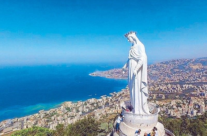
Shrine of Our Lady of Lebanon, Harissa, courtesy, PhilStar.com
Lebanon is located in the center of the eastern Mediterranean coast and is even smaller than Israel. Aside from the Mediterranean, it is bounded on the south by Israel and on the east and north by Syria. Throughout history, Lebanon has constantly had to fight for its ancient Phoenician/Maronite Christian identity, especially against Arab Muslim colonialism, but have only been partially successful - since independence in 1943, by law, the president has to be a Maronite. But on the other hand, the prime minister and speaker of the parliament have to be Arab Muslims and as such, the whole of Lebanon, including the Maronites, was forced to be a full member of the Arab League since its founding in 1945. Since then, the Arabs have successfully brainwashed the Maronites into thinking that they are Arab Christians. Those who refused this identity, were often killed. This was especially so in the 1970s during the civil war when the PLO would massacre approximately 100,000 unarmed Maronite men, women, and children, with the tacit approval of the United Nations. Since the war, the indigenous Lebanese have made impressive economic gains, on a par with that of Europe and Israel, in spite of the fact that they are still persecuted and harassed by the Arabs and are constantly under the watchful eye of Hezbollah.

Before the introduction of Christianity to Lebanon, the Phoenicians, as with most ancient peoples of the time, were pagans. During this period, Phoenicia was never a single unified country, but was made up of four main autonomous city-states, each ruled by their own kings, the two leading city-states being Tyre and Sidon. Byblos and Arwad were next in importance (see Byblos). During the reigns of David and Solomon in Israel, both Tyre and Sidon had mixed Israelite and Phoenician populations even though they were often ruled by Phoenician kings. Sometimes, the kings themselves even had mixed ancestry, for example King Hiram of Tyre who assisted King Solomon in building the Temple in Jerusalem. The following is a list of the ancient Phoenician kings centered in Tyre:

Agenor (ruled from c. 1500 BCE), Phoenix, Eri-Aku, Abi-Milku, Aribas, Baal Termeg, Baal, Pummay, (the list of the next century is unclear and it is resumed again in the early 10th century BCE when Sidon, which was formerly ruled by Ahiram, joined Tyre to form a union, but the kings continued to rule from Tyre), Abibaal, Hiram I, Baal Eser I, Abdastartus, Astartus, Deleastartus, Astarymus, Phelles, Itobaal I, Baal Eser II, Mattan I, Pygmalion;

Under Assyrian rule - Itobaal II, Hiram II, Mattan II, Itobaal III who ruled an independent Tyre;
Babylonian rule - Baal II, Yakinbaal, (monarchy overthrown in favor of judges), Chelbes, Abbar, Mattan III and Ger Ashtari jointly, Baal Eser III, Hiram III who restored the monarchy;

Persian rule - Mattan IV, Boulomenus, Abdemon, the Cypriot Evagoras of Salamis who briefly united Tyre with Cyprus, Eugoras, Azemilcus who reigned during the siege of Alexander the Great, Abdolunim.

Thereafter, the territory of Tyre alternated between Greek and Roman rule.
According to some histories, Saint Peter was the first to evangelize the Phoenicians whom he affiliated to the ancient patriarchate of Antioch. Paul also preached in Lebanon, having lingered with the early Christians in Tyre and Sidon. Even though Christianity was introduced early to Lebanon, its spread was very slow, particularly in the mountainous areas where paganism was still unyielding.
The earliest indisputable tradition of Christianity in Lebanon can be traced back to Saint Maron in the 4th century AD, being of Greek/Eastern/Antiochian Orthodox origin and the founder of national and ecclesiastical Maronitism. Saint Maron adopted an ascetic and reclusive life on the banks of the Orontes river in the vicinity of Homs, Syria and founded a community of monks which began to preach the gospel in the surrounding areas.  
After the Arab conquest and occupation in the 7th century, Saint John Maron, a monk of Sarmin in Syria,  led his followers to the Lebanese mountains to the village of Kfar Hai and there, consolidated Lebanon’s Maronite heritage, often protected by the Marada warriors who were also Maronites. The following is a list of the patriarchs since his time (Druze leaders will be covered in a different posting):

John Maron, Kyros, Gabriel, John Maron II (transferred the patriarchal seat to Yanouh then to Byblos), Youhanna, Gregorius, Stefanos, Mark, Eusebius, Youhanna II, Yeshu, David, Gregorius II, Theophilactus, Yeshu II, Domitius, Ishaq, Youhanna III, Shamun, Urmia, Youhanna IV, Shamun II, Shamun III;

Crusader period (1099-1305) – (During the Crusades, the Maronites went into communion with the Roman Catholic Church.) Yousef al Jirjisi, Butros (the patriarchate briefly moved to the town of Mayfuq but then returned to Byblos), Gregorius, Yacoub, Youhanna V, Boutros II, Boutros III, Boutros IV, Urmia Amchiti, Daniel, Youhanna VI, Shamun IV, Yacoub II, Daniel II, Luqa and Urmia III (the two patriarchs, ruling at the same time, caused a schism in the church but it reunified after the death of Urmia in 1297), Shamun V succeeded and led the Maronites into the:  

Mameluke Egyptian period (1305-1516) - Shamun V, Youhanna VII, Gabriel II, David II, Youhanna el Jaji (transferred the patriarchal seat to Kannoubine), Yacoub el Hadathi, Yousef el Hadathi;

Ottoman Turkish period (1516-1918) - Seman el Hadathi, Mousa Saade el Akari, Mikhail al Rizzi, Sarkis el Rizzi, Yousef el Rizzi, Youhanna Makhlouf, Gewargios Omaira al Duwaihi, Yousef Halib el Akouri, Youhanna el Bawab, Gerges Beseb’eli, Estafanos el Duwaihi, Jibrail II, Yacoub Awad, Yousef V el Khazen, Seman Awad, Tobias el Khazen, Yousef Estefan, Mikhail Fadel, Philip Gemayel, Yousef Tyan, Youhanna Helou, Yousef Hobaish (moved the patriarchal seat to Bkerke), Yousef IX el Khazen, Boulos Massad, Youhanna el Hajj, Elias Peter Hoayek led the Maronites from Ottoman to French rule after WWI;

French rule (1918-1943) – Elias Peter Hoayek, Anthony Peter Arida (led from French rule to independence);

Independence – Anthony Peter Arida, Paul Peter Meouchi, Nasrallah Boutros Sfeir, Bechara Boutros al Rahi (the present incumbent).