 |
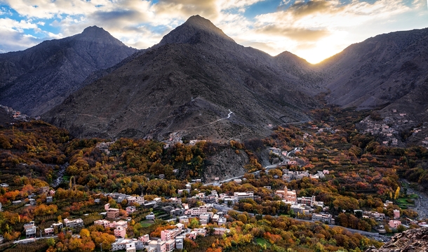
| Berber village in the Atlas Mountains, courtesy Photorator |
The great Atlas Mountain range in northwestern Africa has long been the
homeland (today under Arab occupation) of the indigenous Berber tribes of the
Blida, Chenaoui, Chenoua, Chleuh, Kabyle, Sanhaja, Zayane, and the Zenata. It stretches
about 1600 miles from the west of Morocco, through northern Algeria, to
northern Tunisia and is divided as follows:
The Anti-Atlas, extends
from the Atlantic Ocean in the southwest of Morocco toward the
northeast to the heights of Ouarzazate and further east to the city of Tafilalt (altogether a distance of approximately
310 miles). In the south it borders the Sahara. The easternmost point of the anti-Atlas is
the Jbel Saghro range flanked on its northern border by the High Atlas and includes
the Djebel Siroua, a massif of
volcanic origin. The Jebel Bani is a
much lower range running along the southern side of the Anti Atlas.
The High Atlas, in
central Morocco rises in the west at the Atlantic coast and stretches in an eastern direction to the
Moroccan-Algerian border. It has several peaks over 2 ½ miles above sea level including
the highest summit in North Africa, Toubkal at 13,671 feet, and further east, Ighil m'Goun (13,356 ft) the second major summit of
the range. At the Atlantic and to the southwest, the range drops abruptly and
makes a transition to the coast and the Anti-Atlas range. To the north, in the
direction of Marrakesh, the range descends less abruptly. On the
heights of Ouarzazate the massif is cut through by the Draa Valley which opens southward. From there, the local
Berbers would cultivate the high plains of the Ourika Valley. Near Barrage
Cavagnac there is a hydroelectric dam that has created the artificial lake Lalla Takerkoust. The lake also serves as a source of fish for
the local fishermen.
The Middle Atlas, is completely in Morocco and
is the northernmost of the main three Atlas ranges. The range lies north of the
High Atlas, separated by the Moulouya and Oum Er-Rbia rivers, and south of the Rif mountains, separated by the Sebou River. To the west are the main coastal plains of
Morocco with many of the major cities and, to the east, the high barren plateau
that lies between the Saharan and Tell Atlases. The high point of the range is
the Jbel Bou Naceur.
The Tell Atlas range is
over 930 miles in length, and stretches from Morocco, through Algeria to
Tunisia. It parallels the Mediterranean coast. Together with the Saharan Atlas
to the south it forms the northernmost of two more or less parallel ranges
which gradually approach one another towards the east, merging in eastern Algeria. The area immediately
to the south of this range is the high plateau of the Hautes Plaines, with lakes in the wet season and salt flats
in the dry.
The Saharan Atlas of Algeria is the eastern
portion of the Atlas mountain range. Though not as high as the High Atlas, they
are far more imposing than the Tell Atlas range that runs to the north of them
and closer to the coast. The highest peak in the range is the 7,336 ft
high Djebel Aissa. They mark the
northern edge of the Sahara Desert. The mountains see some rainfall and are
better suited to agriculture than the plateau region to the north.
The Aures Mountains are an eastern continuation of the Atlas Mountain System that
lies to the east of the Saharan Atlas in
northeastern Algeria. They have a lower
elevation than the High Atlas mountains
of Morocco. The highest peak in the
Aurès mountain range is Djebel Chélia in Khenchela Province at 7638 feet above sea level. The Belezma Range is a northwestern continuation of
the Aures Mountains located where the Tell Atlas and
the Saharan Atlas come together. Its main summits are Djebel Refaa (7146 feet) and Djebel
Tichaou (7008 feet). Historically, the Aurès Mountains served as a refuge
for the Berbers, forming a base of resistance
against the foreign occupation of the Roman Empire,
the Vandals,
the Byzantine Empire, the Arabs, and later, the
French.
In ancient times, the kings of Numidia would be buried in the
Madghacens in the city of Batna,
today, located in northeastern Algeria. The Madghacens were the royal
mausoleums, believed to be named after the ancient King Madghacen, common
ancestor of the Botri Berbers as well as the Zenata Berbers
who became the main inhabitants of the Aures region.
Even though North Africa was invaded and occupied by the Muslim
Arabs in the early 8th century during the reign of the Umayyad
caliphs, the Zenata, were among the earliest tribes to adopt Islam, in the 7th.
The Berbers of the Sousse region also adopted Islam, but gradually
and not at the expense of their traditional language, culture and religious
customs which they held on to to varying degrees. Eventually, the
land that became known as Morocco, came under Umayyad rule but their rule was
tenuous due to Berber resistance. In 739 AD an Umayyad Arab army was utterly
destroyed twice by the Moroccan Berbers at the battle of the Nobles, and the
battle of Bagdoura in the Middle
Atlas. In 789 AD, with the approval of the locals, a former Umayyad Arab courtier
established the Idrisid dynasty that
ruled in Fez. It lasted until 970 AD, as various petty states vied for control
over the ensuing centuries. From
the 9th century, Sanhaja tribes were established in the Middle Atlas range, in
the Rif Mountains and on the Atlantic coast of Morocco and
large parts of the Sanhaja, such as the Kutâma, were settled in the central and
eastern parts Algeria (Kabylia, Setif,
Algiers, Msila) and also in northern
Niger. They played an important part in the rise of the Arab Fatimid
dynasty.
In the mid-11th century, a group of Sanhaja chieftains returning
from the Hajj (pilgrimage to Mecca) invited the
theologian Ibn Yasin to preach among their tribes. Ibn Yasin united the tribes
in an alliance with the Berber Almoravid caliphate under Yusuf ibn Tashfin, subsequently
establishing what we know today, as Morocco. From Morocco, they conquered western Algeria and Al-Andalus
(part of present-day Spain).
The Berber
Almohad caliphate was founded by Ibn Tumart, a member of the Masmuda tribal
confederation of southern Morocco. Around 1120, the Almohads first
established a Berber state in Tinmel in
the Atlas Mountains. In 1359 Hintata tribesmen from the High Atlas came down and
occupied Marakesh, ancestral Almohad capital, which they would govern
independently until 1526.
Beginning in the 16th century, the Ottoman Empire
ruled much of North Africa. During this time, a group a
Spanish Muslim refugees settled among the Ouled Soltan of the Blida area. The Zenaga tribes, believed to be descended
from the Zenata or Sanhaja, would often suffer exploitation at the hands of the
Arabs as either semi-sedentary agriculturalists and fishermen or as Marabouts
(religious Muslim leaders and scholars). The Kabyle, on the other hand, were
relatively independent of outside control. They lived primarily in three
different kingdoms: the Kingdom of Kuku
which stretched from the Atlas Mountains to the southern plains of Algiers, the Kingdom of Ait Abbas, and the principality of Aït Jubar. These
areas were gradually taken over by the French during their colonization
beginning in 1857, despite vigorous resistance. Such Kabyle leaders as Lalla Fatma n
Soumer would lead in the resistance even as late as Mokrani's rebellion in 1871. But
due to French colonization, many Kabyle emigrated to other areas in and outside
Algeria. Over time, immigrant workers also went to France. But resistance
against the French continued, especially by the Zayanes of Khenifra in the
Middle Atlas under their warrior leader Mouha ou Hammou Zayani. Thus they succeeded
in preventing many invaders from seizing Khénifra. Despite the French defeat in
the Battle of El Herri, November
13, 1914, the colonizers were determined not to abandon the fight against the
Zayanes.
Since Algeria gained independence in 1962, tensions have arisen
between Kabylie and the central Arab government on several occasions. With the
spread of the Berber Spring in the
1980s, the Berbers sought to reaffirm their roots. In 1980, protesters engaged in several months
of demonstrations in Kabylie demanding the recognition of Berber as an official
language. In June and July 1998, their demonstrations turned violent after the
assassination of singer Matoub Lounes and the passage of a law requiring use
of Arabic in daily life. Afterwards, the Kabyle endured years of abuse by the police
which culminated in April 2001 (called the Black Spring) when a young Kabyle, Masinissa Guermah, was murdered by the
police and major riots among the Kabyle ensued. At the same time, organized
activism produced the Arouch, and neo-traditional local councils. Eventually,
Algerian President Abdelaziz Bouteflika conceded and granted them some human
rights.
Today, the bulk of the Berber population in North Africa have
been confined to the Atlas Mountains. Among their main cities and towns are Ouarzazate,
Tafilalt,
Blida, Batna, Tizi-Ouzou, Tipaza, Khenifra, Barrage Cavagnac, Tahannaout, Amizmiz, Imlil, Tin Mal,
Setif, M’sila and Ijoukak.
No comments:
Post a Comment