For the record, I'm neither an academic nor a scholar, and admittedly, I've never been to many of the places posted here. So if someone should find a mistake, or believe I omitted something, please feel free to email me and I'll correct it.

I can be contacted at dms2_@hotmail.com.

Sunday, December 13, 2020

MODIIN

ancient tomb in Modiin identified as that of
Matityahu, courtesy Wikipedia
Modi'in 02003.JPG
modern Modiin, courtesy, Wikipedia


The city of Modiin is the center of a metropolitan area that also includes the neighborhoods of Maccabim and Re’ut. It is located about midway between Tel Aviv and Jerusalem and is connected to those two cities via Highway 443. In 2019 the population was 93,277. The modern city, built in the 1990s, was named after the ancient Jewish town of Modi'in, the place of origin of the Maccabees.  

During the time of Joshua, the site of Modiin was allotted to the tribe of Judah on its northwestern border, probably where the tribal borders of Dan and Benjamin meet. By the 2nd century BCE, the town became the residence of the priestly Hasmonean (later referred to as the “Maccabee”) family and was headed by Matityahu. The First Book of Maccabees described his genealogy as "Mattathias, the son of John, the son of Simeon, a priest of the sons of Joiarib, from Jerusalem; and he dwelt at Modin" (I Macc. ii. 1). He had five sons: Judah (Judas Maccabaeus), Eleazar, Simon, John, and Jonathan. In 168 BCE, the ruler of the Syrian-Greek Seleucid Empire which also ruled over Judea, was Antiochus Epiphanes. He had sent his soldiers under Apelles, who is mentioned by Josephus but not in the Book of Maccabees, to Modiin, in order to set up an altar to the heathen god, and ordered Matityahu, as the most influential citizen, whose example would be followed, to sacrifice in accordance with the king's command. He responded: "Though all the nations that are under the king's dominion obey him, . . . yet will I, and my sons, and my brethren, walk in the covenant of our fathers" (I Macc. ii. 19-20). And when a certain Jew was about to obey the command, Matityahu, who was filled with holy wrath, killed the offender and destroyed the altar, while his sons cut down the king's officer. Thus began the Jewish revolt against Seleucid rule and the Hellenisation of the Jewish population. The revolt succeeded in driving out the Seleucids, and the rededication of the Second Temple in Jerusalem at the end of the revolt is commemorated by the Jewish holiday of Hanukkah. In c. 165 BCE, Matityahu died and was buried in Modiin. His children were also buried there and their tombs can still be seen today. After expelling the Seleucids, the Maccabees formed the Hasmonean dynasty, which ruled Judea in the 2nd and 1st centuries BCE.

Simon eventually built a splendid mausoleum at Modiin, which was adorned with seven pyramids and high columns with sculptures of ships that were said to be visible from the sea (i Macc. 13:25–30; Jos., Ant. 13:210–11). In the time of Jonathan, Modiin and the surrounding area was passed into Jewish possession. An important battle was undertaken against the Seleucid Kendebaois from a camp situated close to Modiin. Judas Maccabaeus is mentioned as having marched out of the town in order to fight Seleucid forces sent against him by Antiochus v (ii Macc. 13:14ff.), suggesting that Modiin was unfortified. John and Judah camped close to Modiin before the battle of Kidron (i Macc. 16:4).

Archaeological excavations have revealed remains dating from this period including a late 2nd/early 1st century BCE synagogue, in use until 132 CE (Bar Kokhba revolt), and a 1st-century CE mikveh standing next to it. Modiin was the home town of R. Eleazar of Modi'in, a close relative of Bar Kokhba and perhaps identical with Eleazar the high priest, who appears on coins of the Bar Kokhba revolt. R. *Eleazar was put to death in 135 CE on grounds of treason. Another teacher associated with Modi'in was Rabbi Yossi, but details regarding him and his teachings are sparse.

Abandoned shortly afterward, the ensuing centuries were taken up with travelers, pilgrims, and archaeologists, attempting to identify the location of the ancient town as well as of the Tombs of the Maccabees.

In 1944, during World War II while Israel was under a British Mandate, the custom of the annual Hanukkah torch relay, starting from the Tombs of the Maccabees in Modiin, was established by the Maccabi Sports Federation. Originally, a torch, carried by Israeli runners starting from the site of the Tombs, would make its way to Federation headquarters in Tel Aviv. However, since the 1950s and continuing to this day, the torch would first go to Jerusalem to light the national menorah, then to other parts of the country, and even to communities in the Diaspora.

In July 1948, during Israel’s War of Independence, the area west of the Naḥal Modi'im gorge was occupied by Israeli forces while the Arab settlement of al-Midya remained beyond the 1949 armistice line under Arab Jordanian occupation.  

In the 1950s and 1960s, the Herzl Forest of Ben Shemen was gradually enlarged eastward to become the Modi'im Forest, and an observation tower and amphitheater were built there. In 1964, the Modi'im region development project was started, providing for further afforestation and land reclamation; the area's northern section was set aside as an ultimate reserve for the expansion of the Tel Aviv metropolitan area, with plans laid out for the construction of a future city to be named Makkabit. In 1965, a Naḥal outpost settlement, Mevo Modi'im, was established less than a mile from the armistice line by a group affiliated with Po'alei Agudat Israel. After the *Six-Day War, these settlers moved southeastward to set up a new village in the Ayalon Valley, at the foot of the Beth-Ḥoron ascent, while the site of Mevo Modi'im, which has poor and rocky soil, was earmarked for a village to be based on industry and a Po'alei Agudat Israel seminary. Forest planting continued after 1967 on both sides of the former armistice line, carried out in the west by Jewish laborers and in the east by Arabs.

In 1985, the construction of the town of Maccabim, which was led by the International Maccabi organization began, and the project of founding nearby Re'ut, led by an association of Israeli army officers, started in 1987. The towns were united into Maccabim-Re'ut in 1990. Meanwhile, the modern-day city of Modiin was planned by the famed Israeli architect Moshe Safdie. The cornerstone was laid in 1993. It was built as a modern planned city with high standards of urban planning. Environmental issues and future growth were taken into consideration from the early design stages. Large greenspaces were incorporated into the city's layout and today comprise 50% of the area within the city limits. The city was opened for residency in 1996. It was later merged with Maccabim-Re’ut to create the unified municipality of Modi'in-Maccabim-Re'ut. In 2008, it was decided to cap the growth of Modi'in to allow for the development of Lod and Ramla.

In 2007, Modi'in was selected as one of the inaugural cities for the Israel Baseball League. The baseball team was named the Modi'in Miracle, but did not play games in Modi'in as there is no baseball stadium there.

In 2008, the Pioneers of the Israeli Football League (American Football) relocated to Modi'in. The Pioneers played all their home games in Modi'in. In their first year, they won the IFL Championship. After an unsuccessful 2009–10 season, their second in Modi'in, the Pioneers relocated once again to Tel Aviv, where most of the team's players lived.

In 2014, Modi'in was the site of the funeral for the kidnapped and murdered teens Naftali Fraenkel, Gil-Ad Shaer and Elad Yifrah. Prime Minister Netanyahu spoke at the funeral.

The city center is a large traffic circle. On the north side of the circle is the central train station, to the northeast is the Azrieli shopping mall, and to the west and south is the Anaba park which contains a small artificial lake used for recreational boating. The traffic circle straddles a major northeast–southwest artery, HaHashmona'im Blvd., that connects to the southwest with route 431 and to the northeast with route 443 (at Shilat Junction) providing connectivity to Jerusalem (southeast) and Lod (northwest).

Approximately 3 miles west-northwest of the city center is an industrial zone, and to the west (on route 431) is the Yishpro commercial center. The industrial zone is also linked to route 443 via its own interchange, between Shilat Junction and the Maccabim Junction at the eastern side of the Ben Shemen JNF forest. This keeps most of the commercial traffic out of the city proper, so that the two arteries between the city and its industrial zone (Emek HaEla and HaShdera Hamerkazit) carry primarily commuters rather than trucks.

Aside from Maccabim-Re’ut, the following neighborhoods surround Modiin: HaShvatim, Moriah, HaPrachim, HaNachlim, Masuah, “Malibu”, HaKramim, Avnei Chen, HaNevi’im, HaMeginim, and HaTzipporim.

Sunday, December 6, 2020

MIZPAH

ruins of ancient Mizpah, courtesy, Pinterest
The Biblical Mizpah is the name of several towns located around the Land of Israel. The location that this posting will concentrate on will be that in the tribal territory of Benjamin, north of Jerusalem as described in Joshua 18:26. On several occasions, this Mizpah served as the seat of assemblies at which the Israelites discussed their affairs. When a Levite traveler's concubine was raped and murdered by the men of nearby Gibeah, a town in Benjamin, the other tribes of Israel met at Mizpah where they decided to attack the men of Benjamin for this grievous sin. At the same time, the decision was made not to permit marriage between Israelite women and Benjaminite men. Later, Mizpah was a major meeting place in the time of Samuel who assembled the people there in order to fight against the Philistines who had stolen the Ark of the Covenant. After the return of the Ark, Samuel gathered all Israel at Mizpah to offer a sacrifice to the Lord and ask Him to forgive their sin. It was also at Mizpah that the people of Israel identified their first king – Saul – who was chosen by lot from all the tribes and families of Israel. During the time of the divided kingdom, King Asa of Judah fortified Mizpah against the attacks of the King of Israel (I Kings xv. 22; II Chron. xvi. 6). Gedaliah, the son of Ahikam, established the capital of Judah there after the Babylonian destruction of Jerusalem (II Kings xxv. 23; Jer. xl. 6 et seq., xli. 1); he was later assassinated by Ishmael, a surviving member of the House of David (ii Kings 25:22ff.; Jer. 40–41). The prophet Jeremiah settled there after his release from the Babylonian Captivity. Under Nehemiah, Mizpah served as a district capital (Neh. 3:7, 15, 19). Since the time of the Maccabees, it was a place of solemn assembly (I Macc. iii. 46) for the worship of god. In the 1st century, it was a seat of learning and home to the Tanna Shimon of Mizpah.

According to the 12th century Spanish rabbi and traveler Benjamin of Tudela, the town was identified with the town of “Nov” and it still contained a Jewish community. Yehoseph Schwarz, who explored the land in the mid 19th century, found the site occupied by the Arab settlement of Tel al Safiyah. Modern archaeologists, however, have placed the location of ancient Mizpah at the ruins of, what the Arabs refer to as, “Tel en Nasbeh”, about 8 miles north of Jerusalem. Other archaeologists however, have identified one other site - Neby Samwil, a place of pilgrimage for Jews for thousands of years and located almost 600 feet above the plain of Gibeon. 

Sunday, November 29, 2020

MISHMAR HAEMEK

View of Mishmar HaEmek's new neighborhood
courtesy, Wikipedia
Mishmar HaEmek is a kibbutz in northern Israel, located in the southwestern part of the Jezreel Valley, between Highway 66 to its northeast and the foot of the Menashe Heights to its southwest. It falls under the jurisdiction of the Megiddo Regional Council and is one of the few kibbutzim that have not undergone privatization, still following the traditional collectivist and socialist kibbutz model.  Next to the kibbutz is Mishmar HaEmek Forest, planted by the Jewish National Fund and members of the kibbutz. It is a section of Megiddo Park (formerly named "Ramot Menashe park"), listed as a biosphere reserve by UNESCO. Flowing through Mishmar HaEmek is the Nahal Mishmar HaEmek, a tributary of the Kishon River. Some of the waters also come from the Spring of Shulamit. In 2019, it had a population of 1,271. At least six former members of the Knesset hail from Mishmar HaEmek.

In Biblical times, the site of Mishmar HaEmek was allotted to the tribe of Menasheh (on the west side of the Jordan) in the northwestern section of the tribal territory between Megiddo and Yokneam. The present kibbutz sits near the ancient site of Tel Shush which Israeli geographers and archaeologists have identified as the ancient Jewish village of Geva‘ Parashim from the time of the Hasmonean dynasty. Between the Arab conquest in the 7th century and the 1920s, Bedouin and Turkmen tribes settled in the area, founding the settlement of Abu Shusha.  In the 1870s, much of the Jezreel Valley came under the ownership of the Sursock family, a Greek Christian family in Lebanon. From 1924 to 1926, the land in and around the area of the present kibbutz, including Abu Shusha, was purchased by the Jewish National Fund.

The pioneers of Mishmar HaEmek came to Mandatory Palestine during the Third Aliyah. They were Polish Jews from Galicia and were members of three groups who graduated from the HaShomer HaTzair movement, one from the town of Afula and two from the Jerusalem area. They later joined with another Zionist socialist group from Hadera and on November 3, 1926, the members (numbering 90 after the unification) were given the land next to Abu Shusha. But initially, only 15 men and women went to the site, and they settled in a nearby khan, from where they began preparing for agricultural work. In the next year, two mules were bought and 120 dunams of wheat and barley were sowed. Soon, the pioneers left the khan and began building the new settlement in its present location, making history as the first Jewish settlement in this part of the valley since Biblical times. As a HaShomer HaTzair stronghold, the settlement housed many pioneers of other kibbutzim and instructed them before they established their own kibbutzim.

In November 1928 the kibbutz was renamed "Kibbutz Mishmar HaEmek" as proposed by Menachem Ussishkin, after its members could not agree on a name. On August 26, 1929, during the bloody Arab riots, the kibbutz was attacked. The members, with the aid of Arab policemen, managed to fend off the rioters. British policemen ordered the kibbutz to evacuate and promised to take care of their property, and so the members left the following day. On August 28, Arab rioters burned the barn, uprooted trees, stole corn from the fields and vandalized two gravestones in the cemetery. It was the only time in its history where Mishmar HaEmek was abandoned, and it joined 16 other Jewish communities that were also abandoned during the riots. But unlike the others, it was resettled six days later. 

In 1931, Shomeria School was established as the first regional educational institution of the Kibbutz Artzi movement, an ideological ally of Hashomer HaTzair. It soon became the biggest structure in the region and operated as a boarding school. It put into practice HaShomer HaTzair's socialist ideology, creating an independent "children's society." The pupils saw their parents only on holidays or special visiting days throughout the year. This institution provided education to several other kibbutz communities that were established in the Jezreel Valley as well as youth from the Youth Aliyah. In the mid-30s, the members also constructed a water tower, built a cowshed, planted a vineyard and various fruit trees, and dug wells. Berta Guggenheimer was an activist who planned playgrounds all over the country and with her niece Irma Lindheim, a member of Mishmar HaEmek, set up the kibbutz’s own children's playground. There was also an arrangement to allow Arab children from the nearby villages to visit and play with the kibbutz children.

At the start of 1936–39 Arab revolt in Palestine, Mishmar HaEmek came under attack from nearby Arab settlers under the command of Ahmad Attiyah Awad, succeeded by Yusuf Abu Durra after his death. There were repeated arson attacks on grain fields and forests and were described by a member as a "crime greater than murder," as the burning of the wheat fields denied the members their main food source. Around 30,000 trees in the kibbutz's vicinity were destroyed and an enormous amount of property was lost. There were no direct attacks on the kibbutz itself, but almost every night there were stray shots fired in its direction. Many of the kibbutz men had to spend time guarding instead of working the fields. British High Commissioner Arthur Grenfell Wauchope visited the kibbutz and appointed 15 members as armed guards; however, in August 1936, the situation worsened when the attacks became more frequent. The British government sent 60 soldiers to the kibbutz and by October the attacks on the kibbutz ended. But not ambushes. On February 2, 1938 Abraham Goldschleger, a kibbutz member and guide for Ein HaShofet, was ambushed and murdered by the Arab settlers of Al-Kafrayn. Two residents of Ein HaShofet who accompanied him were also killed in the attack. One of the shooters was caught and executed. 

During World War II, the nearby Palmach Cave was chosen by the Palmach upon its establishment in 1941, as a training site for its special undercover units. The cave was also used for meetings between Palmach commanders. In the fall of 1942, Mishmar HaEmek was used as a training camp by the British army. 160 Jewish volunteers, members of Palmach,  were trained by Royal Engineers in sabotage and wireless operations. Several tons of explosives were hidden in caches in case the area came under German occupation. This program was eventually terminated and orders were issued for the collection of all equipment and explosives to be returned to the British.

In 1947, the Jewish National Fund and Worton Hall Studios made a movie entitled The Great Promise (Dim'at Ha'Nehamah Ha'Gedolah), and a number of scenes were filmed in Mishmar HaEmek. By 1947, Pinat HaGola ("Diaspora's Place") was built by the sculptor Zeev Ben Zvi as a memorial site for the children who died in the Holocaust. He built it with the students of the kibbutz. It was the earliest memorial site for the Holocaust in Israel.

On April 4, 1948, during the War of Independence, the kibbutz came under full-scale attack by the Arab Liberation Army (ALA). The leader of the ALA, Fawzi al-Qawuqji, planned to seize Mishmar HaEmek in order to control the route between Jenin and Haifa. The attack began with a barrage from seven artillery pieces supplied by the Arab army of Syria. During the shelling, houses were destroyed, civilians, defenders, and animals were killed and the prominent school building was heavily damaged. A bomb shelter was later built there. The Pinat HaGola was also damaged by a shell, but Ben-Zvi refused to repair it. On April 6, the women and children of the kibbutz were evacuated to other settlements in the Jezreel Valley and a ceasefire began during which the Jewish forces fortified the kibbutz and dug trenches around its perimeter.  

Although the Arab forces had not entered the kibbutz, Qawuqji reported that the kibbutz was captured and the "conquest of Mishmar HaEmek" was falsely celebrated in Arab newspapers, which also reported heavy casualties among the Jewish forces. The ALA sent terms to the Haganah, saying they would lift the siege of the kibbutz, regroup and move toward Haifa if the Jewish forces would not retaliate against the nearby Arab villages in return. The Jewish forces declined the offer and the Arab offensive resumed on April 8. That night, the Jewish forces launched a counter-attack under the command of Yitzhak Sadeh and captured the nearby Arab village of Al-Ghubayya al-Fawqa in a fierce battle. In the next days, troops of the Carmeli Brigade and the Palmach unit captured several other villages near Mishmar HaEmek and nearby Ein HaShofet, and destroyed them all. During the second phase of the war, on December 24, Iraqi planes bombed the kibbutz, hitting the children's house, killing four children and injuring another four.

After the war, in 1950, the kibbutz finished building a new large dining hall and kitchen, whose construction was delayed during the war. That same year, the people of Mishmar HaEmek established a plastics factory called Tama, which in time became a central part of the kibbutz's economy. The factory was created to provide work for the elderly, since at the time Mishmar HaEmek had the highest number of elderly residents among the entire Kibbutz Artzi network. In the 1970s, a 25% stake was sold to Kibbutz Gal’ed.

In May 1950 an adjacent village and ma'abara (immigrant transit camp) called Keren Yesha was established for Yemenite Jews by the Jewish Agency. It was located atop Tel Shush, where the first members of the kibbutz settled in 1926. Eventually, political rivalries affected the relations between the two communities. The Hed Ha-Mizrach newspaper described life in Keren Yesha two months after its establishment, stating that the Yemeni immigrants lived in tents and although the residents claimed to be content, they also said that there was not enough support by the authorities. The newspaper Al HaMishmar, affiliated with the Kibbutz Artzi movement, reported that the kibbutz helped the new community and provided a number of services to the new immigrants. The newspaper reported that the Moshavim Movement, which held rival social and political views, was officially responsible for Keren Yesha, and asked that the kibbutz would cease its aid, telling the residents that they needed to choose between aid from Mishamr HaEmek or the Moshavim Movement.

In July 1951, Keren Yesha protested against negligence by the authorities and blocked the nearby road. The newspaper Davar, affiliated with the Mapai party, reported that the protest was organized by the members of Mishmar HaEmek affiliated with the rival Mapam party and also claimed they have denied water and medical treatment to the immigrants after they decided to support Mapai. This report caused outrage among kibbutz members, who denied the accusations and claimed that the relations between both communities are good and that the kibbutz provides the village with the support that the authorities fail to the deliver. Later, Davar issued an apology, saying it was a false report. In 1953, Keren Yesha was abandoned and the residents moved to nearby Midrakh Oz.

Mishmar HaEmek suffered from the 1983 bank stock crisis. In an attempt to save the kibbutz from bankruptcy, Tama began manufacturing plastic netting used for bundling crops and in the late 1980s the crisis ended. Several successful business moves by Tama in the early 1990s led the kibbutz to an era of economic prosperity and high quality of life. During that period, education in the kibbutz was reformed, the children's societies were abolished, and the pupils were moved to schools outside of the kibbutz. This allowed the kibbutz to extend existing houses and set up new neighborhoods. Prosperity led the kibbutz to increase the salaries of its members, to create personal funds for families, and to institutionalize culture and recreational activities thanks to the weekly labor days, reduced to five.

On April 1 1990, 15,000 people (according to Maariv) participated in a parade from the Menashe forest to Mishmar HaEmek in protest of the objection of Rabbi Elazar Shach to prevent a political coalition between the Haredi parties and the leftist parties which he described as "eaters of hares and swine" (non-Kosher food). Many leaders of the Israeli left and right participated in the parade. In August, some members of the kibbutz and those of Kibbutz Artzi-affiliated kibbutzim, signed a petition calling upon the kibbutz movement to launch a non-violent protest against Israel Defense Forces actions against murderous Palestinians in Judea and Samaria during the First Intifada. The residents of Mishmar HaEmek represented the more Arab-friendly and peace-oriented left-wing of the Israeli Labor Movement. Some of the movement's leaders, such as Mordechai Bentov and Ya'akov Hazan, hailed from the kibbutz.

In 2010 the kibbutz decided, after a series of public meetings, to appoint a team of members to discuss the privatization of electricity, food, mail, barbershop and cosmetics. Other services were to be kept under the responsibility of the kibbutz, including healthcare, education and welfare. The dispute mainly concerned the privatization of the dining room. At the end of the discussions, most privatization initiatives were rejected and only a few minor changes that had no practical effect on the collective lifestyle were accepted.

Various services have developed in the kibbutz; some of them are operated privately by the kibbutz members, such as the "IDEA Information System", which provides software for 70% of the museums in Israel, including Yad Vashem. In 2019 the kibbutz finalized a deal with the kibbutzim of Evron and Sa'ar to buy a quarter of their share of a company called Bermad, estimated to be worth around 450 million NIS. The company manufactures water control products that are provided to over 70 other companies, with annual revenue of half a billion NIS, employing around 700 workers.

Other sites in Mishmar HaEmek include: the Plant Nursery, the Basketball Hall, the Winery, the Mishmar HaEmek Cemetery, and the Mishmar HaEmek Battle Memorial Monument.

Sunday, November 22, 2020

MIKVEH YISRAEL

administration building, Mikveh Yisrael agricultural school,
courtesy, Times of Israel
Mikveh Yisrael is a youth village and boarding school in the Tel Aviv District of central Israel, established in 1870. It was Israel’s first Jewish agricultural school and indeed the first modern Jewish settlement in Palestine outside of Jerusalem, heralding a new era in the history of the region.

In Biblical times, the site of present-day Mikveh Yisrael was allotted to the tribe of Dan. It was in close proximity to Jaffa, the port city of ancient Israel. In the final decades of the Ottoman Empire, this area would see intense Jewish activity. About 1860, several orthodox rabbis, among whom were Zvi Hirsch Kalischer and Elijah Gutmacher, developed a plan for the colonization of Palestine with Russian and Rumanian Jews. This plan was soon after supported by the Maskilim (Progressists). The latter induced the Alliance Israélite Universelle, of Paris, to interest themselves in the matter, notwithstanding the circumstance that many members of the Alliance doubted the adaptability of the Jews to agricultural work. When Charles Netter, emissary of the Alliance, visited Israel in 1868, he visualized an agricultural school surrounded by a settlement as the beginning of a future network of Jewish villages. And in April 1870, Mikveh Yisrael was founded on a tract of land southeast of Jaffa leased from the Ottoman Sultan, who allocated 750 acres to the project. The name was taken from two passages in the Book of Jeremiah, 14:8 and 17:13, and was proposed by Wolf Grinstein, one of the school's first students, who later taught there. Netter was the first director of the school and it aimed to be an educational institution where young Jews could learn agriculture, learn new methods, and thus giving them the means to establish villages and settlements all over the country and to make the desert blossom. Mikveh Yisrael was credited with introducing the eucalyptus tree from Australia for the purpose of draining the swamps. It soon gained the support of the Anglo-Jewish Association. In 1882 the first *Bilu pioneers found work and were trained there immediately upon arrival in the country. Baron Edmond James de Rothschild contributed to the upkeep of the school.

Netter was succeeded by Joseph *Niego who directed the school from 1891 to 1914. In 1898, Theodor Herzl met the German Emperor Wilhelm II at the settlement’s main entrance. 

From 1914 to 1955, the school was under the direction of Eliyahu Krause. During his tenure, Mikveh Yisrael became a pioneering ground for the introduction and improvement of new farm branches. Hebrew became the language of instruction soon after Krause had taken over. For many decades the school served as the research center for the country. Their teachers wrote the first study books about agriculture and served as field advisors. Most of the agricultural know-how of the first 50 years was collected and published by Mikve Yisrael. After finishing their studies, the thousands of graduates left Mikve Yisrael to start agricultural settlements of all kinds, villages and kibbutzim, moshavim, farms and agricultural schools; or serving in management positions; or continued their agricultural studies in institutions of higher learning and filling positions in research and development, the export branches, marketing and agricultural management.

The botanical garden was established in 1930 in order to adapt and acclimate trees and species to the Israeli climate. Plants were imported from all over the world. It now covers now 70 dunams.

Since the 1930s Mikveh Yisrael has become an important education center for *Youth Aliyah. In 1938–1939, at the request of the Youth Aliyah, a section for religious youth was built to house the religious and traditional youngsters who fled western Europe just before the start of the Holocaust. It occupied 1.2 sq. mi. and included a cultural center, a library named after Krause, experiment stations, and a botanical garden featuring over 1,000 species. Agriculture included field crops, fruit orchards, citrus groves, greenhouse crops, sheep, poultry, and bees.

In the Israel *War of Independence (1948), the school was attacked several times. In 2007 Mikve Yisrael and the Alliance Israélite Universelle inaugurated an experimental bilateral Israel-France high school, the Collège-Lycée franco-israélien Raymond Leven, with half of its pupils studying for the French Baccalauréat and half for the Israeli Bagrut. 

The agricultural grounds of Mikve Yisrael cover over 2,200 dunams (out of a general area of 3,300 dunams). Most of the fields are irrigated using wells and include field crops, industrial crops, vegetables, fruit trees, orange groves and greenhouses. The school also raises animals including milk cows, chickens and honey bees, as well as having auxiliary branches including computerized agriculture.

One dunam is covered by greenhouses. The aim of the greenhouse production branch is to allow students to research greenhouse issues and technologies. A rainwater harvesting system allows efficient re-use of water collected from the roof for growing of vegetables in greenhouses.

Also on the premises, a stable was established having the following breeds of riding horses: Hanoverian, Holland and quarter-horse breeds suited to all types of horseback riding: western, sports, and therapeutic riding.

Mikveh Yisrael has been instrumental in developing novel techniques in citrus and other farm branches, introducing avocado cultivation and the acclimatization of many livestock strains, and while it operated the Mikveh Yisrael wine cellars, select wines and liqueurs were produced.


Tuesday, November 10, 2020

MERON

yeshiva and entrance to Tomb of Shimon bar Yohai, Meron, courtesy, TheYeshivaWorld.com

Meron is a town in northern Israel with a population of 985 as of 2019. Located on the slopes of Mount Meron in the Upper Galilee near Safed, it falls under the jurisdiction of the Merom HaGalil Regional Council. The town is most famous for the Tomb of Rabbi Shimon bar Yochai, a rabbi renowned for his mysticism who, it is alleged, wrote the kabbalistic book, the Zohar, and is adjoined to an ancient yeshiva. The tomb is the site of the annual mass public commemoration of Lag Ba'Omer.

In the Bible, Meron is mentioned as the site of Joshua's victory over the Canaanite kings and its subsequent allotment to the tribe of Naphtali. Josephus fortified Meron in the 1st century CE and called the town Mero or Meroth. It is mentioned in the Talmud as being a village in which high-quality olive oil was produced and many sheep were reared. It has been suggested that merino, the celebrated wool, may have had its etymological roots in Meron. In the last decade of the 3rd century CE, a synagogue was erected. Known as the Meron synagogue, it survived an earthquake in 306 CE, though excavations at the site indicate that it was severely damaged or destroyed by another earthquake in 409 CE. It has remained in ruins ever since and has become a major landmark. Some time in the 4th century CE, Meron was abandoned for reasons as yet unknown but was later reoccupied some time between 750 and 1399. In the 12th century, Benjamin de Tudela visited Meron and described a cave with tombs, believed to hold the remains of Hillel, Shammai, and "twenty of their disciples and other Rabbis". The French Rabbi Shmuel ben Shimshon, while on a visit to Meron in 1210, located the tombs of Shimon Bar Yochai and his son Eleazar b. Simeon. He also stated that there were 336 other tombs, and outside of the village, the tombs of Simeon Ḥaṭufah and of the prophet Obadiah. From the 13th century onward, Meron became the most frequented site of pilgrimage for Jews in Palestine. In the early 14th century, Arab geographer al-Dimashqi reported that Jews and possibly non-Jewish locals travelled to celebrate a festival, which involved witnessing the sudden and miraculous rise of water from basins and sarcophagi in the cave. A similar scene was also described by the 15th century Italian rabbi, later Chief Rabbi of Israel, Ovadiah di Bertinoro, the Italian traveler Rabbi Moshe Basola in the 16th century and by the American archaeologist Edward Robinson in the 19th. It has been a custom at the Meron celebrations, dating from the time of Rabbi Isaac Luria, that three-year-old boys are given their first haircuts (upsherin), while their parents distribute wine and sweets. It was reported that during the earthquake of 1837, the walls of the tombs of Rabbi Eleazer and Rabbi Shimon were dislodged, but did not collapse. Laurence Oliphant visited Meron sometime in the latter half of the 19th century. His guide there was a Sephardic rabbi who owned the land that made up the Jewish quarter of the village. Oliphant writes that the rabbi had brought 6 Jewish families from Morocco to till the land, and that they and another 12 Muslim families made up the whole of the village's population at the time.

Towards the end of World War I, the ruins of the Meron synagogue was acquired by the "Fund for the Redemption of Historical Sites" (Qeren le-Geulat Meqomot Histori'im), a Jewish society headed by David Yellin.

Today, the modern moshav Meron is located at the foot of Mt. Meron, and is affiliated with the Ha-Po'el ha-Mizrachi Moshavim Association. Founded in 1949, near the yeshivah and remnants of the ancient Meron synagogue, by immigrants from Hungary and Czechoslovakia, it specialized in hill farming, with deciduous fruit orchards, dairy cattle, and poultry.

On July 14, 2006, a Katyusha rocket fired from Lebanon exploded in Meron, claiming 2 lives—Yehudit Itzkovich, 57, and her 7-year-old grandson Omer Pesachov—and injuring four others. A new barrage of rockets hit Moshav Meron on July 15; there were no injuries.

Among the local attractions are the Meron Vineyards. Meron is conducive to growing grapes for wine as a result of its 600-meter altitude and chalky soil. The vineyard was first planted in 2000 and is part of the Galil Mountain Winery, headquartered in nearby Kibbutz Yiron. 

Sunday, November 1, 2020

TRIBE OF MENASHE

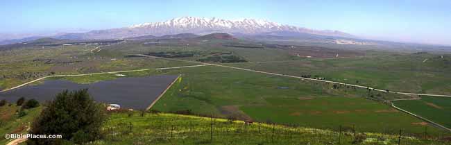
the eastern part of Menashe today, courtesy, BiblePlaces.com
For previous postings about parts of Menashe, see Samaria and Bashan/Golan Heights.

Menasheh was born in Egypt, the first born of Joseph by Osnat, daughter of Potiphar, priest of On. According to Genesis 41:51, Joseph named him “Menasheh” because “…god has made me forget (נשני Nashani  ) all my toil…” referring to the time when he was sold by his brothers to a caravan going to Egypt, and his subsequent imprisonment in Egypt. The Bible refers to the descendants of Menasheh as a “half tribe”, probably because he was not the son of Jacob. By the time the Children of Israel were on the edge of the Promised Land, Menasheh was divided into east and west. The eastern portion of the tribe settled in their lands first. In Numbers 32:33 and 39, it is stated that eastern Menasheh took possession of the lands of Gilead and Bashan, which stretched as far as the town of Edrei in the east and, what is now known as the Golan Heights in the west. The cities of eastern Menasheh are listed in scattered places in the Bible, but mainly in Numbers 32:41 and Joshua 13:30-31: Ashtarot, a royal city of Bashan, Edrei, another royal city where Og, King of Bashan, was defeated and his lands given over to Menasheh, Golan, set aside by Joshua as a city of refuge and was held by the Gershon branch of the Levites, the Havot Yair bloc, Nobah, and Salchah. Of Salchah nothing is known but the fact that it was a boundary city.

The western portion of the tribe took possession of its land during the time of Joshua. Roughly, this territory consisted of the lands from the Carmel mountain range and across the Jezreel Valley to the Jordan, including the towns of Megiddo and Bet She’an in the north, and going southward, until the northern border of Jaffa in the west, the southern border of Shechem in the center, and the southern border of Gilgal in the east, thus, consisting of the bulk of the Jordan Valley. The cities of Menasheh on the west side of the Jordan, many of which were shared with the tribe of Ephraim, are listed in Joshua 17: Bet She’an, Dor, Ein Dor, Ible’am, Megiddo, Michmetah, Taanach, the area that became Haifa, Ein Tappuah, Gilgal, Shechem, and Shomron.