For the record, I'm neither an academic nor a scholar, and admittedly, I've never been to many of the places posted here. So if someone should find a mistake, or believe I omitted something, please feel free to email me and I'll correct it.

I can be contacted at dms2_@hotmail.com.

Monday, July 12, 2021

TEL HAI

view of original courtyard, Tel Hai, courtesy, Wikipedia

Tel Hai is a name of the former Jewish settlement in northern Galilee, the site of an early battle between Jews and Arabs heralding the growing conflict. It is currently part of kibbutz Kfar Giladi.

In Biblical times, the site that would become Tel Hai was allotted to the tribe of Naphtali. Apparently, there was never a settled community there although at some point during the rule of the Ottomans, an Arab settlement was established called Talhah. At the beginning of the 20th century, some of the village lands were purchased by Haim Kalvarisky, a clerk of the Jewish Colonization Association, and in 1905, a Jewish community was established as an agricultural courtyard for six workers from Metullah. It was to lie on the northern border of the hoped-for Jewish state but such hopes were disappointed by the European colonial powers during the First World War. In a letter dated October 24, 1915, Sir Henry McMahon, then British High Commissioner in Egypt, and in recognition of the Arab Revolt against the occupying Turks, promised the Sharif of Mecca, Husayn ibn Ali, to "recognize and support the independence of the Arabs within the territories proposed by him (Sharif of Mecca)”, the exact extent of which became a matter of dispute. In 1918, following the defeat of the Ottoman Empire, the Jewish community was given its name, “Tel Hai”, the Hebraicized form of Talhah, and became a border outpost settled by the "Shepherd's Group" of Hashomer, predecessor of the Haganah, in order to guard outlying Jewish land. One year later this group dispersed and another took its place under the command of Josef Trumpeldor. The area was subsequently subject to intermittent border adjustments among the British and French colonial powers. In 1919, the British relinquished the northern section of Upper Galilee containing Tel Hai, along with Metulla (est. 1896) and Kfar Giladi (est. 1916) to French jurisdiction. The Zionist movement was greatly displeased with this, since it would have left the sources of the Jordan River outside the borders of British Mandatory Palestine. Therefore, the few isolated settlements in this territory assumed a strategic value from the Zionist point of view. Still, there was a fierce debate among factions and leaders of the Yishuv. Some, including the Hashomer force in Tel Hai under Trumpeldor, advocated letting Tel Hai and the other outposts hang on at all costs, while others regarded their situation as untenable and advocated withdrawing from them. Arabs in this area at the time were not primarily involved in activities against the early Jewish defense forces but rather in strongly opposing the imposition of the French Mandate of Syria, which they regarded as a betrayal of the McMahon–Hussein Correspondence. Organized Arab militias were, hence, established thus beginning the Franco-Syrian War. While the local Arabs and Bedouin allied with the Arab Kingdom of Syria, the Jewish residents chose to remain neutral. Early in the war, a Kfar Giladi resident was killed by armed pro-Syrian Bedouin, greatly increasing tension in the region. Jewish villages were regularly pillaged by the Bedouin on the pretext of searching for French spies and soldiers. In one incident, Trumpeldor and other Jews were stripped of their clothes as a public insult by an Arab Bedouin militia. On March 1, 1920, several hundred Shiite Arabs from the settlement of Jabal Amil in what is today, southern Lebanon, marched to the gates of Tel Hai together with Bedouin from Halasa and their Mukhtar, Kamal Affendi. They demanded to search Tel Hai for French soldiers. One of the farmers fired a shot into the air, a signal for reinforcements from nearby Kfar Giladi, which brought ten men who had been posted by Hashomer to organize defense. Trumpeldor and these men attempted to influence the Shiites and roving village militias to go away through negotiation. Kamal Affendi was allowed to enter the village however to search for French soldiers. He encountered one of the female Jewish residents named Deborah who pointed a pistol at Kamal, apparently surprised to see an armed Bedouin in the village. A shot was discharged during the struggle (unclear whether from the pistol or by another weapon) and a major firefight erupted. Trumpeldor was shot and seriously wounded, while the sides barricaded themselves in the village. Kamal Affendi asked to leave, saying it was all a misunderstanding, and the Jewish force approved a cease-fire. During the Arab retreat, one of the Jewish defenders, unaware of the agreements by his comrades and hearing-impaired by the previous firefight, shot at the Arab party, and the exchange of fire recommenced. Eight Jews and five Arabs were killed. Trumpeldor was shot in the hand and stomach and died while being evacuated to Kfar Giladi that evening. The survivors of Tel Hai found their position untenable and had no choice but to withdraw, whereupon the Arabs set fire to the village. In the end, Tel Hai was included in the British Mandate of Palestine. By 1921, it was resettled though it did not become a viable independent community and in 1926 it was absorbed into Kfar Giladi.

The Battle of Tel Hai which gave the settlement its fame, was significant, from a Jewish perspective, far beyond the small number of civil combatants on either side – mainly due to its influence on Israeli culture, both inspiring an enduring heroic story and profoundly influencing the military of the Yishuv and political strategies over several decades. In retrospect, it can be regarded as the first military engagement between Jews and Arabs, though at the time neither side regarded it as such. Each year, Tel Ḥai Day is celebrated by youth gatherings and visits to Tel Ḥai and similar sites. Today, the Roaring Lion Monument in the Kfar Giladi cemetery commemorates the deaths of the eight Jews in the battle.  The nearby city of Kiryat Shemona, literally Town of the Eight was named after them. There are also the Academic and Technology College of Tel Hai, an industrial park, and the Tel Hai Springs. The original quadrangular compound was preserved, and a youth hostel and Haganah museum were established there.

Sunday, July 4, 2021

MOUNT TABOR

view of Mount Tabor, courtesy, Wikipedia
Mount Tabor is located in Lower GalileeIsrael, at the eastern end of the Jezreel Valley, about 11 miles west of the Sea of Galilee. Today situated off Highway 65, in ancient times, it lie on the road of the Via Maris, an ancient trade route, which stretched from the Jezreel Valley to Damascus. Shaped almost like half a sphere, it is an independent-standing mountain, suddenly rising from rather flat surroundings and reaching a height of 1,886 feet above sea level, overlooking the town of Kfar Tavor. At its base it is almost fully surrounded by the Arab and Bedouin villages of DaburiyyaShibli, and Umm al-Ghanam. Its summit is accessible by road via Shibli. A hiking track, as part of the Israel National Trail, starts from Shibli and is about three miles long. Its location on the road junction and its bulgy formation above its environment gave Mount Tabor a strategic value resulting in wars that were fought for its possession in different periods in history. The mountain was a major factor in the defeat of Napoleon’s armies in 1799 that halted his Middle Eastern ambitions and eventually drove him back to Europe.

The mountain is mentioned for the first time in the Bible in the Book of Joshua, 19:22, as the border of three tribes: ZebulunIssachar and Naphtali. According to the Book of Judges, Mount Tabor was the location of the Battle of Mount Tabor between the Israelite army under the leadership of Barak and the army of the Canaanite king of HazorJabin, commanded by Sisera. Deborah the Jewish prophetess had summoned Barak of the tribe of Naphtali and gave him God's command, "Go and draw toward mount Tabor, and take with thee ten thousand men of the children of Naphtali and of the children of Zebulun" (Judges 4:6). This resulted in the Canaanites’ total defeat. A cave near the top of the mountain may have been the original sanctuary of the Greek god Zeus Atabyrios (from which, the name “Tabor” supposedly derived). Centuries later, this sanctuary was revived by the Israelites, calling forth the wrath of the prophet Hosea (5:1). In the days of the Second Temple (c. 516 BCE – 70 CE), Mount Tabor was one of the mountain peaks on which it was the Jewish custom to light beacons in order to inform the northern villages of the start of the holy days and of the beginning of the new months. In 55 BCE, during a Hasmonean rebellion against the Roman proconsul of SyriaAulus GabiniusAlexander of Judaea and his army of 30,000 Judeans was defeated in battle at Mount Tabor. As many as 10,000 Jewish fighters were killed in the battle and Alexander was forced to flee, apparently to Syria. In Christian tradition, Mount Tabor is the site of the transfiguration of Jesus. In 66 CE, during the First Jewish-Roman War, the Galilean Jews retrenched on the mountain under the command of Yosef Ben Matityahu, better known as Josephus Flavius, the later historian, whence they defended themselves against the Roman assault. Itabyrium, as Josephus called it, was one of the 19 sites fortified by the rebels in Galilee under his very orders. According to what is written in his book The Wars of the JewsVespasian sent an army of 600 riders, under the command of Placidus, who fought the rebels. Placidus understood that he could not reach the top of the steep mountain with his forces, and therefore called the fortified rebels to walk down the mountain in order to negotiate. Figuring it was a trick, a group of Jewish rebels did so supposedly for that reason, but instead, they attacked him. The Roman forces initially retreated, but while they were in the valley, they returned towards the mountain, attacked the Jewish rebels, killed many of them, and blocked the road for the remaining rebels who tried to flee back to the top of the mountain. The remaining rebels on the mountain surrendered after their water ran out. They then handed it over to Placidus. After the destruction of the Second Temple, Jewish settlement on Mount Tabor was renewed. Several centuries later, the Jewish inhabitants left, for various reasons, for other parts of the Levant and the site was subsequently fought over between Christians and Muslims as well as between various Arab tribes. At the end of the 19th and the beginning the 20th centuries, the Bedouin tribe Arab Al-Sabehi settled on the mountain and became one of the strongest tribes in the region. Eventually, other branches of the tribe were formed, most notably the Shibli, and they settled around the base of the mountain. Jews first returned to the region in 1901 with the establishment of Kefar Tavor. In 1933, the Kadoorie Agricultural High School was founded north of the village by the monies of the legacy of Sir Ellis Kadoorie, a Baghdadi Jewish merchant from China. The Jewish inhabitants had fostered good relations with many (but not all) of the Arab tribes in the region, like the Arab-Al Heib, who began their military cooperation with the Jewish underground forces since the late 1930s. In 1944, the kibbutz Beit Keshet was founded on the northern base of the mountain.

During the War of Independence (1947-1949), members from the Al-Sabehi fought in the Arab Liberation Army under the Syrian Arab Fawzi al-Qawuqji and among other atrocities, they murdered seven members of Beit Keshet in cold blood. At the start of May 1948 the Israeli Golani Brigade occupied the mountain itself. Most of the Sabehi were forced out to Arab-occupied Syria and Jordan, except for the Shibli branch. After the war, the surrounding property of the Kadoorie School became the Kadoorie Regional Center and the local Jewish and Arab towns came under its administration. Since 1953, the regional council of Lower Galilee holds a 12-kilometer race around Mount Tabor, held in April each year, in memory of Yitzhak Sadeh, the first commander of the Palmach and one of the founders of the Israel Defense Forces at the time of the establishment of the State of Israel.

Meanwhile, the Shibli village of Arab al-Shibli was established and today, it is part of the village of Shibli-Umm al-Ghanam.  It was admitted as a tourist village by the Israeli government and the locals are famous for being hospitable and very friendly to visitors. Since the late 1960s many of the tribesmen joined the Israeli security forces (such as the IDF, Border Guards Unit and police, etc.).

As part of the Jewish National Fund's efforts to recreate the Biblical landscapes of the country, during the 1960s and 1970s the area was reforested with trees which were similar to its original vegetation such as Mount Tabor Oak, “Palestine” oak, the Persian lily, Mt. Tabor larkspur, and Galilean alkanet. The woodland vegetation provides a good habitat for such fauna as wolves and jackals, foxes, porcupineshyraxesmongooses and the broad-toothed field mouse. In addition, reptiles and birds of various species have also settled in the woodland areas.

Friday, June 25, 2021

SURA

Sura-Iraq
depiction of an ancient or medieval school at Sura, courtesy, notebookm.com

Today, the site of the ancient city of Sura is located in the southern half of Arab-occupied Iraq. At one time, a mixed Assyrian and Jewish town and part of the Assyrian/Babylonian Empires, Sura came under Roman control in the time of Pliny the Elder (23-79 CE) during which time, the Assyrians, especially in and around the town, had adopted Christianity giving rise to the Assyrian Church of the East. By the year 253, it was conquered by the Persian Sasanian emperor Shapur I and at some point, Sura became solely inhabited by Jews becoming a major center of Torah scholarship and home to an important yeshiva - the Sura Academy founded by Abba Arikha - which, together with the yeshivot in Pumbedita and Nehardea, gave rise to the Babylonian Talmud in the 5th/6th century. Sura was also well-known for its agricultural produce, which included grapeswheat, and barley.

The town was a Byzantine garrison of some importance in the Persian campaigns of military commander Belisarius. A full account is given of the circumstances under which it was taken and burned by the Persian Emperor Chosroes I (532 CE); incidental mention of the bishop proves that it was then an episcopal see. Its walls were so weak that it did not hold out more than half an hour but it was afterwards more substantially fortified, by order of the Byzantine Emperor Justinian. Sura declined as a Jewish center in the 6th and 7th centuries due to constant subsequent wars and upheavals and remained in ruins ever since. In the 7th century, the approximate area was conquered and colonized by the Arabs, who introduced Islam, in which state it remains to this day. Sura itself was never again re-inhabited, not by Jews or Christians or anyone else.  

According to Sherira Gaon, Sura was identical to the town of Mata Mehasya, which is also mentioned in the Talmud, but Mata Mehasya is cited in the Talmud many times, either as a nearby town or a suburb of Sura, and the Talmudic academy in Mata Mehasya served as a branch of the Sura Academy. A contemporary Syriac source described Sura as a town that was completely inhabited by Jews, situated between Māḥōzē and al-Hirah in the Sawad. A responsum of Natronai ben Hilai says that Sura was about 3.7 miles from al-Hirah. Today, the Assyrian Christians, the indigenous inhabitants of the land who are mainly followers of the Chaldean Catholic Church, inhabit areas around Sura, the nearest communities being around 40 to 85 miles away. For example, the Chaldean Church of the Virgin Mary is located approximately 44 miles to the north in the town of Hillah. In the town of Ayn al Tamr near Karbala, approximately 80 miles northwest of Sura, is the Al-Aqiser Church, an ancient church built in the 5th century CE and considered to be among the oldest eastern Christian Churches in the Middle East outside of Israel. Until recently it was in active use.


Sunday, June 20, 2021

SODOM AND GOMORRAH

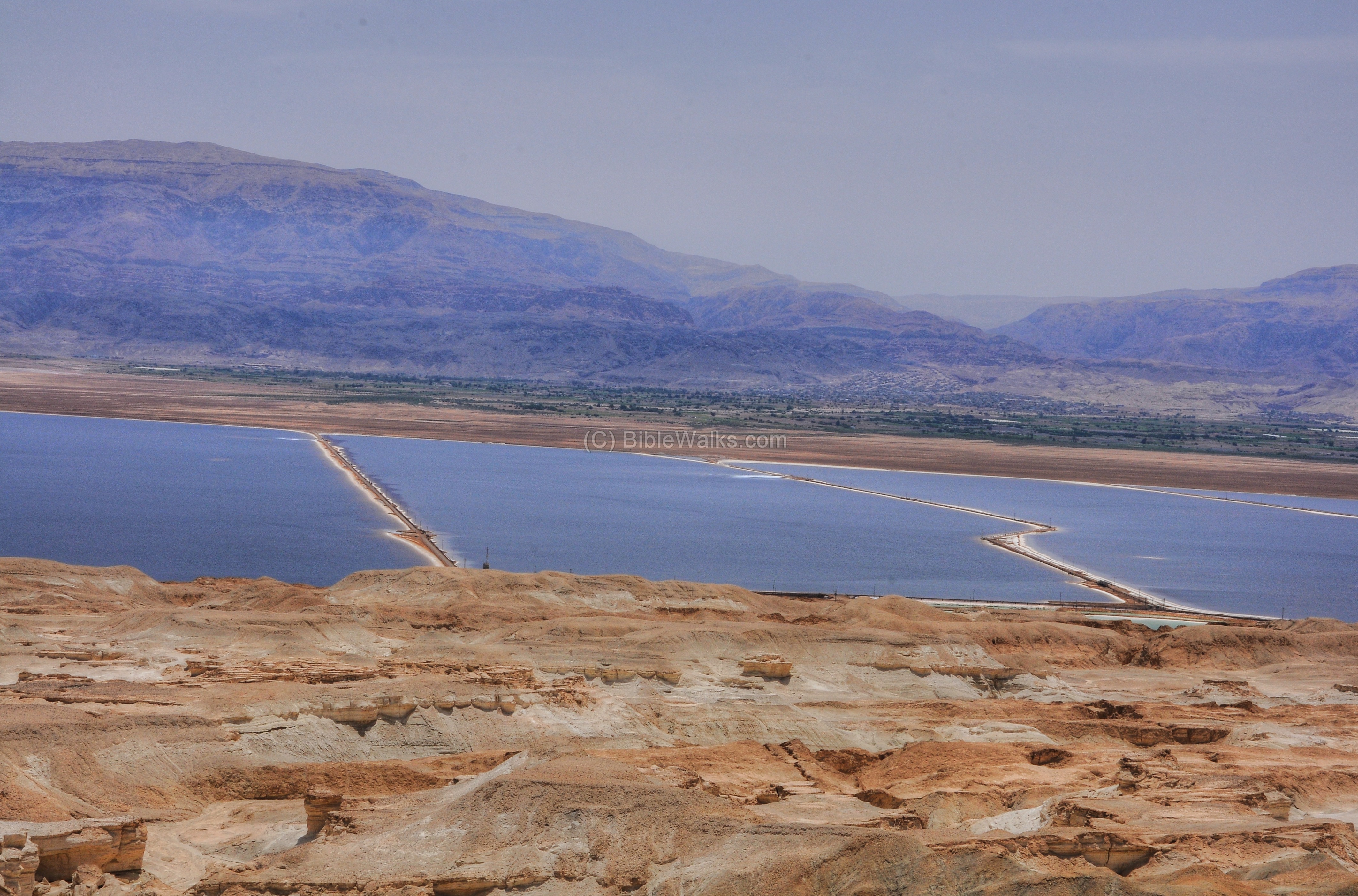
supposed site of Sodom and Gomorrah, southern shore of
the Dead Sea, courtesy, BibleWalks.com

In modern-day usage, the words “Sodom and Gomorrah” have become bywords of evil and debauchery. But most people forget that Sodom and Gomorrah were actual places, twin city-kingdoms, the location of which is, what the majority of scholars and archaeologists agree, at the southern end of the Dead Sea in Israel, or the approximate area.

When Israel was called “Canaan” during the time of Abraham, the inhabitants of the land were Canaanites of various tribes, including Sodom and Gomorrah. According to the Torah, these two cities, along with the cities of AdmahZeboim, and Bela (later called Zoar) were known as the "cities of the plain" and this plain was often compared to the garden of Eden as being well-watered and green, suitable for grazing livestock. The Book of Genesis in the Torah is the primary source that mentions Sodom and Gomorrah. The Battle of the Vale of Siddim is described in Genesis 14:1–17Lot, nephew of Abraham, was encamped within the borders of Sodom at a time when "the men of Sodom [are] wicked and sinners before the Lord exceedingly". Sodom and Gomorrah were ruled by Bera and Birsha, respectively, although their kingship was not sovereign because the Jordan plain had been under the rule of Chedorlaomer king of Elam for twelve years. In the thirteenth year of their subjugation, the five kings of the plain — those of the two cities, as well as Shinab of AdmahShemeber of Zeboiim, and the unnamed king of Bela — allied to rebel against Elam. The following year, Chedorlaomer gathered forces from his allies - ShinarEllasar and Goyim to suppress the rebellion in the Siddim. The cities of the plain took heavy losses and were defeated. Sodom and Gomorrah were despoiled and captives were taken, among them Lot. The tide turned when Lot's uncle, Abraham, gathered an elite force that slaughtered the hosts of Chedorlaomer in Hobah, north of Damascus, freeing the cities of the plain from the grip of Elam.

The story of the judgment of the two cities is told in Genesis 18–19. Two men (angels?), emissaries of god, came to Abraham in the plains of Mamre. After they received the hospitality of Abraham and Sarah, the Lord revealed to Abraham that he would confirm what he had heard against Sodom and Gomorrah, "and because their sin is very grievous." The two men then proceeded to Sodom, and Abraham inquired if the Lord would spare the city should fifty righteous people be found within it, to which the Lord agreed. He then pleaded for mercy at successively lower numbers — forty-five, then forty, thirty, twenty, and finally ten — and the Lord agreed each time. Upon arrival at Sodom, the men were met by Lot, who convinced them to lodge with him. “But before they lay down, the men of the city, even the men of Sodom, compassed the house round, both young and old, all the people from every quarter. And they called unto Lot, and said unto him: 'Where are the men that came in to thee this night? Bring them out unto us, that we may know them.'” Lot refused but instead, offered them his two virgin daughters "which have not known man…do ye to them as [is] good in your eyes". They refused and proceeded to break down his door. Lot's guests rescued him and struck the men with blindness. They informed Lot of their mission to destroy the city, then they commanded him to gather his family and leave. As they made their escape, one angel commanded Lot to "look not behind thee". As Sodom and Gomorrah were being destroyed with brimstone and fire from the Lord, Lot's wife looked back at the city, and she became a pillar of salt. It has been theorized that if the story does have a historical basis, the cities may have been destroyed by a natural disaster. One such idea is that the Dead Sea was devastated by an earthquake between 2100 and 1900 BCE and the resulting upheaval might have unleashed showers of steaming tar. This idea might be a possibility especially if the cities lay along a major fault such as the Jordan Rift Valley, however there are no known contemporary accounts of seismic activity that corroborate this theory.

Since the cities’ destruction, they remained partly in ruins and partly covered over with sand and debris until their exact locations became lost to history. It wasn’t until the advent of local explorations and archaeology, beginning in the 19th century, that the scientific study, and attempted locations, of Sodom and Gomorrah commenced, notably by an American expedition in 1849 under Naval Commander William Francis Lynch who studied the Jordan River and Dead Sea areas. He based himself on the Biblical text which, according to Genesis 13:10, clearly stated that “…the whole plain of the Jordan toward Zoar was well watered, like the garden of the Lord, like the land of Egypt. (This was before the Lord destroyed Sodom and Gomorrah.) And in fact, later explorers have discovered a ruined site at the southern end of the Dead Sea coast which some have identified as Sodom and they hypothesized that Gomorrah, as well as the three other cities, were nearby, on the seabed under water. In addition, a salty outcropping near the site was called, by the local Bedouin, Lot’s Wife. Other sites proposed, in various locations on both the northern and southern coasts were, Har Sedom, Bab edh Dhra, Numeira, al Safi, Feifa, Khirbet al Khanazir, and Tel el Hamam. However, no widely accepted or strongly verified sites for the cities have been found.  In 1929 the Palestine Potash Co. (today, the Dead Sea Works) was established at Kalia in the northern Dead Sea area. The opening of the Sedom branch works in the south was built a few years later. The carnallite extracted at Sedom was ferried over the Dead Sea to Kalia, where, during World War II, potash production reached an approximate 100,000 tons annually, thus supplying about half of Great Britain's requirements at the time. The relatively small quantities of bromide also constituted an important contribution to the Allied war effort. The 1947 UN Partition plan provided for the inclusion of Sedom and the Dead Sea shore as far north as En-Gedi in the proposed Jewish state. During the War of Independence, the Sedom Works, accessible only by boat, were completely cut off for many months. Reinforced by the workers and residents from Kalia and Bet ha-Aravah, who were expelled by Arab forces in May 1948 and could only be transferred to Sedom, the core of the laborers held out under severe hunger and thirst until contact with the rest of Israel was renewed in "Operation Lot" (December, 1948). After the war, the Kalia works found itself under Arab occupation and were completely razed by the Arab Legion; thus the renewal of production at Sedom had to be deferred until 1954, after the Beersheba-Sedom road was built. In 1955, the Bromide Company was founded, and it set up its factory near the Sedom Works. Soon after, both enterprises were integrated into the Dead Sea Works. In 1964, a workers’ camp for the Dead Sea Works was founded at Neve Zohar a few miles to the north. Later, two other villages, not necessarily connected to the Dead Sea Works, were founded a few miles to the south: Neot Hakikar in 1970 and Ein Tamar in 1982.


Friday, June 11, 2021

POOL OF SILOAM (SHILOACH)

Historic pool of Siloam where Hezekiah's tunnel ends, Jerusalem, Israel Stock Photo - 50758074
a view of the ancient Pool of Siloam (Shiloach), courtesy, 123rf.com
The Pool of Siloam (Shiloach in Hebrew) is an ancient rock-cut pool on the southern slope of the City of David in Jerusalem, situated outside the walls of the Old City, to the southeast.

During the time of Joshua, the site where the Pool would be located, was in the southern point of the tribal territory of Benjamin. Centuries later, it was built during the reign of King Hezekiah (715–687/6 BCE), in order to prevent access to Jerusalem’s water source at the nearby Gihon Spring by the besieging Assyrian armies under Sennacherib. The pool was fed by the newly constructed Siloam tunnel which connected it with Gihon. An older Canaanite tunnel had been very vulnerable to attackers, so under threat from the Assyrians, Hezekiah sealed up the old outlet at Gihon and built the new Siloam tunnel in its place (2 Chronicles 32:2–4). During the Second Temple period, it was centrally located in the Jerusalem suburb of the Acra also known as the Lower City. Often, it would have an excess of water due to an overflow of water in the tunnel caused by an overflow in the Gihon. The pool was reconstructed no earlier than the reign of Alexander Jannaeus (103-76 BCE). According to the Jerusalem Talmud, since Siloam was a freshwater reservoir, it was the starting point and major gathering area for those who made the annual pilgrimage to Jerusalem, and where they ascended by foot to the inner court of the Temple Mount to bring their sacrificial offerings. It remained in use during the time of Jesus. According to the Gospel of John, Jesus sent "a man blind from birth" to the pool in order to complete his healing. “…And [Jesus] said unto him [the blind man], Go wash in the Pool of Siloam. He went his way therefore, and washed, and came seeing." The Mishnah tells us of the practice of filling stone cups (clearly the so-called "measuring cups") with the Pool’s waters (Par. 3:2). One should also mention an interesting text from Oxyrhynchus in Egypt – a fragment of an uncanonical gospel – which refers to a mikveh-like pool close to the Temple area with separate stairs for going in and out. It served as a landmark in Josephus' descriptions of Jerusalem during the siege by the Roman General Titus, and marked the boundary between the sections defended by John of Gischala and Simeon Bar-Giora (Wars, 5:140, 252). After the Romans crushed the Jewish rebellion in Jerusalem in the year 70, the pool was destroyed and covered but served as a refuge for the rebels afterwards (6:401).

In the 1870s, the pool was visited by the French Jewish traveler and explorer Joseph Halevy. In 1884 Jews from Yemen established themselves in Shiloach village which overlooked the pool but in 1936, they were ethnically cleansed by the Arabs and British authorities. In 1967, after the Six-Day War, the village and the pool itself became incorporated into the Jerusalem municipal area. In 2004, the pool was the site of a major archaeological expedition in preparation for a building project. The expedition was conducted by Ir David Foundation workers, following a request and directions given by archaeologist Eli Shukron accompanied by Ori Orbach from the Israel Nature and Parks Authority.

Tuesday, June 1, 2021

SHILOH

ancient Tel Shiloh, courtesy, Wikipedia
Shiloh is an ancient city in Samaria, located about 27 miles north of Jerusalem, including about 2 miles north of the Arab settlement of Turmus Aya, with the archaeological mound of Tel Shiloh adjacent on its west. In 2019 it had a population of 4,356, which includes the neighborhood of Shvut Rachel.

Shiloh is mentioned in the Book of Genesis as part of the benediction given by Jacob to his son Judah: "The scepter shall not depart from Judah, nor a lawgiver from between his feet, until Shiloh comes, and unto him shall the gathering of the people be." (Genesis 49:10). This passage could refer to a person, perhaps the Messiah, or a place, as mentioned later in the Books of Judges and Jeremiah 41:5. When the Israelites arrived in the land, they set up, in Shiloh, the wilderness tent shrine – the Tent of Meeting as described in Joshua 18:1: “The whole congregation of Israel assembled together at Shiloh and set up the tent (or tabernacle) of the congregation there.” This was also where the Ark of the Covenant was placed. The Tent remained in Shiloh for the next 369 years; the Ark, until its capture by the Philistines. From Shiloh, Joshua and Eleazar divided the land among those Israelite tribes who had not yet received their allocation (Joshua 18:1–10) and also dealt with the allocation of cities to the Levites (Joshua 21:1–8). Subsequently, Shiloh, which would come to be located in the tribal territory of Ephraim, became one of the leading religious shrines in ancient Israel. The people made pilgrimages there for major feasts and sacrifices, and Judges 21 records the place as the site of an annual dance of maidens among the vineyards. According to 1 Samuel 1–3, a young Samuel was dedicated by his mother Hannah, to be raised at the shrine by Eli, his own prophetic ministry having begun there. The sons of Eli, Hophni and Phinehas are noted as malicious in their dealings with those who came to the shrine to offer sacrifices (1 Samuel 2:12–17). And it was under Eli that the Ark was lost to Israel in a battle with the Philistines at Aphek“Then a man of Benjamin ran from the battle line the same day, and came to Shiloh with his clothes torn…” This was the first ever recording of a marathon, centuries before the Greeks. (After the Six Day War in 1967, the founder of the Macabiah Games, Yosef Yekutieli, sought to revive that path that was taken. Eventually, it became, what is known today, as the Bible Marathon, held every September/October.) The high status of Shiloh in ancient Israel was held until shortly before David made Jerusalem, Israel’s capital. Still, the town played a major part in the subsequent history of ancient Israel. According to the Biblical account, Ahijah the Shilonite, who instigated the revolt of Jeroboam, the son of Nebat, against David's grandson Rehoboam (I Kings 11, 14) was a native of Shiloh. But according to archaeological radiocarbon dating, Shiloh was abandoned around 1050 BCE, a century before the revolt, and then sparsely repopulated during the Iron II period, well after the revolt. What is certain though, is that during the prophetic ministry of Jeremiah (7th-6th centuries BCE, Jeremiah 7:12–15; 26:5–9, 41:5), Shiloh had been reduced to ruins. Jeremiah's admonition in the course of his temple sermon, "Go now to my place that was in Shiloh" (Jeremiah 7:12), would have occurred during this era. Jeremiah used the example of Shiloh to warn the inhabitants of Judah and Jerusalem what Yahweh Elohim will do to the "place where I caused my name to dwell," warning them that their holy city, Jerusalem, like Shiloh, could fall under divine judgment.

Shiloh is in the vicinity of the road that connects Meron with Rama, and the proximity to this route seems to have brought Jewish pilgrims to it since the time that the annual ziyara was established during the Ayyubid period (late 12th century). Many would describe the former location of the Tabernacle as well as the burial place of Eli the priest and his sons. Eli’s tomb also appears in a lamentation called “Kivrey Avot” (“Tombs of the Fathers”), whose author is unknown and which was dated to the 12th or 14th century. This work also mentions the well-known phenomenon of multiple tombs around a central tomb. “To the two sons of Eli the Elder in Shiloh and he has a place and there is where the mother of Ichabod is buried”. Prominent Jewish visitors to the site included: R. Samuel ben Shimshon (Rashbash), who accompanied R. Jonathan of Lunel, one of the greatest sages of Provence, Yaakov Hashaliach (Jacob the Messenger) author of Simaney Hakvarot, who was affiliated with R. Yechiel of Paris, Ishturi haParhi the 14th century traveler and writer from France, and Isaac Chelo, an explorer from Spain who wrote: “…There are the tombs of Eli the High Priest and his two sons Hofni and Pinhas, a very fair monument where Jews and Muslims light candles constantly. One kabbalist old man sits by this gravestone. He is from Ashkenaz and he supports himself by copying holy books…” Several years later, in 1335, the Augustine monk Jacopo of Verona paid a visit, accompanied by his Jewish guides. There seemed to be a consensus especially among Jewish, as well as Samaritan pilgrims, that Biblical Shiloh was identified as the contemporary Arab settlement of Seilun as indicated in the Samaritan book of Joshua, written in Arabic in 1362. Shiloh is mentioned as one of the holy places in the Land of Israel in a record from the Cairo Genizah from the 14th or 15th century. The last Jewish mention of Shiloh was in the “Sefer Yuhasin” (“Book of Genealogy”) from 1442. Since then, the site remained an Arab settlement but the Jews often took part in common rituals together with local residents. Once the village declined and disappeared in the Ottoman period, the various pilgrims who had visited disappeared as well, and only in the 1830s did American archaeologist Edward Robinson suggest the identification anew resulting in a renewed interest among pilgrims and other visitors. In the mid-19th century, Rabbi Yehoseph Schwarz visited Shiloh and there, alluded to the Tomb of Eli.

In 1948 during Israel’s War of Independence, Shiloh, as with the rest of Judea and Samaria, fell to Arab forces from Jordan, and it remained under Arab occupation until 1967 when Israel liberated these areas in the Six Day War. Beginning in 1974, Shiloh was considered a potential site for resettlement as the ancient site was legally situated on state-owned land. In January 1978, a modern community was established adjacent to the ancient biblical site, Tel Shilo. In 1979, Shiloh was officially included in the list of towns under the Jurisdiction of the Settlement Section of the Jewish Agency. (Today, the village is administrated by the Mateh Binyamin Regional Council.) Yeshivat Hesder Shilo was founded in 1979 by Rabbi Michael Brom who continues to serve as Rosh Yeshiva. Rabbi Aharon (Arele) Harel served as co-Rosh Yeshiva for five years before resigning from his position prior to the start of Hebrew year 5771 (October 2010). Midreshet Binat in Shvut Rachel, a midrasha headed by Rabbi Ronen Tamir, was established in 2000 as a branch of the Yeshiva. Shiloh is also home to its main synagogue which is designed as a replica of the Biblical Tabernacle. It contains replicas of many of the utensils used in the original Tabernacle. In 1981–1982, Zeev Yeivin and Rabbi Yoel Bin-Nun excavated at the presumed site of the tabernacle. An extensive excavation was done by Israel Finkelstein during the years 1981–84. In the summer of 2010, excavations at Tel Shilo were carried out under the auspices of the Staff Officer for Archeology in the Civilian Administration Antiquities Unit in cooperation with the Mateh Binyamin Regional Council. One notable find was a Roman coin from the period of the Bar Kokhba revolt. Digs are currently led by Scott Stripling.

Other local places of interest in Shiloh include: Lady Feyga Jewelry Store, Ohel Shiloh School, Sofer Zol Grocery Store, Marelo Italian Restaurant, the Shiloh Industrial Zone, the Shiloh Winery, the Dvorah Pinokim Cake Shop, Armon Hasfarim, Siun Tzovirei Beauty Supply Store, Bet Tachshitim Jewelers, Shiloh-Jerusalem Puzzle Quest tourist attraction, Wadi Musa on the easter, southern, and western outskirts, and Wadi Ali on the northern outskirts.